
Midpeninsula Regional Open Space District facts for kids
The Midpeninsula Regional Open Space District, often called Midpen, is a special organization in the San Francisco Bay Area that protects natural land. It was started in 1972 when voters decided to create it. Midpen's job is to buy and take care of large areas of open land, creating a green belt of nature around the cities.
This protected land includes parts of Santa Clara, San Mateo, and Santa Cruz counties. Midpen works to connect its lands with other parks to create a huge, continuous area of nature. It also works with other groups on big trail projects like the San Francisco Bay Trail and the Bay Area Ridge Trail.
Midpen protects more than 70,000 acres (28,000 ha) of land. This includes rolling foothills, forests of giant redwood trees, and grasslands near the coast. This land is spread across 26 different areas called "open space preserves." You can visit 24 of these preserves for free, any day of the year, from sunrise until a half-hour after sunset.
The district's main goal is: To acquire and preserve a regional greenbelt of open space land in perpetuity; protect and restore the natural environment; and provide opportunities for ecologically sensitive public enjoyment and education.
This means they want to protect these natural spaces forever, help the plants and animals that live there, and give people a chance to enjoy and learn about nature in a way that doesn't harm it.
Fun Things to Do
Most of the preserves are open for fun outdoor activities. The most popular things to do are hiking, cycling (mountain biking), and horseback riding.
Some preserves offer unique activities. At Windy Hill Open Space Preserve, people with a special permit can go paragliding and hang gliding. While camping isn't allowed in most places, the Monte Bello Open Space Preserve has a special camp for backpackers who get a permit.
As of 2025, Midpen has 259 mi (417 km) of trails.
- Bicycles are allowed on 163 mi (262 km) of trails.
- Horses are welcome on 223 mi (359 km) of trails.
- Leashed dogs can go on 63 mi (101 km) of trails.
The preserves are kept very natural. Most just have a parking lot, trail signs, and sometimes a simple bathroom.
Park rangers watch over the preserves to help visitors and protect the land. They are trained officers who wear tan and green uniforms.
List of Preserves
Midpen manages 26 beautiful open space preserves. Most are open to the public for free. Here are some of them:
| Name | Acquired | Area | Trails | Notes | Access | Refs. |
|---|---|---|---|---|---|---|
| Bear Creek Redwoods | 1999 | 1,440 acres (580 ha) | 6 mi (9.7 km) | A beautiful forest with redwood trees. | 3 mi (4.8 km) S of Los Gatos; SR 17 to Bear Creek Road | |
| Cloverdale Ranch | 2023 | ? | 1 mi (1.6 km) | A newer preserve with coastal views. | SR 1, near Pigeon Point Lighthouse | |
| Coal Creek | ? | 500 acres (200 ha) | 3.7 mi (6.0 km) | Named for the creek that runs through it. | Skyline Blvd, approximately 1.2 mi (1.9 km) north of Page Mill Rd and 6 mi (9.7 km) south of SR 84 | |
| El Corte de Madera Creek | 1988 | 2,908 acres (1,177 ha) | 34.8 mi (56.0 km) | Has many trails for hiking and biking. | parking lots off Skyline Blvd, approximately 2.7 and 4 mi (4.3 and 6.4 km) north of SR 84 | |
| El Sereno | 1975 | 1,614 acres (653 ha) | 6.9 mi (11.1 km) | Named for the 2,500 ft (760 m) Mount El Sereno. | 3 mi (4.8 km) west of SR 17 at Bear Creek Road / Montevina Road exit | |
| Foothills | 1972 | 212 acres (86 ha) | 0.3 mi (0.48 km) | One of the first preserves created. | Page Mill Road, 3.5 mi (5.6 km) southwest of I-280 | |
| Fremont Older | 1975 | 739 acres (299 ha) | 14.7 mi (23.7 km) | named for Fremont Older, a writer and editor. | exit SR 85 at De Anza, then take Prospect Road to parking space | |
| La Honda Creek | Nov 2017 | ? | 10.6 mi (17.1 km) | Has an upper area that requires a free permit to visit. | (Lower) via Sears Ranch Road, off SR 84 | |
| Long Ridge | 1985 | ? | 14.1 mi (22.7 km) | Connects to the famous Skyline-to-the-Sea Trail. | parking lots west of Skyline Blvd, approximately 3.6 mi (5.8 km) north of SR 9 and 3.3 mi (5.3 km) south of Page Mill Road | |
| Los Trancos | 1976 | 274 acres (111 ha) | 6 mi (9.7 km) | Known for its earthquake trail along the San Andreas Fault. | Page Mill Road, 7 mi (11 km) west of I-280 and 1.5 mi (2.4 km) east of Skyline Blvd | |
| Miramontes Ridge | ? | ? | ? | This preserve is currently closed to the public. | N/A | |
| Monte Bello | ? | 3,436 acres (1,390 ha) | 15.5 mi (24.9 km) | "Monte Bello" means "beautiful mountain" in Italian. | Page Mill Road, 7 mi (11 km) W of I-280 and 1.5 mi (2.4 km) E of Skyline, adjacent to Los Trancos. | |
| Picchetti Ranch | 1976 | 308 acres (125 ha) | 3.7 mi (6.0 km) | A historic winery, Picchetti Winery, is located here. | From I-280, take Foothill Expy exit and travel 3.5 mi (5.6 km) southwest to Montebello Rd, continue 0.5 mi (0.80 km) on Montebello to preserve. | |
| Pulgas Ridge | ? | ? | 6.2 mi (10.0 km) | A great place for hiking with dogs off-leash in a designated area. | ||
| Purisima Creek | ? | ? | 22.8 mi (36.7 km) | Features a canyon filled with tall redwood trees. | ||
| Rancho San Antonio | ? | ? | 26 mi (42 km) | Very popular for hiking and visiting a historic farm. | ||
| Ravenswood | 1981 | 376 acres (152 ha) | 2.1 mi (3.4 km) | Located by the bay, great for bird watching. | ||
| Russian Ridge | ? | 3,491 acres (1,413 ha) | 13.1 mi (21.1 km) | Famous for its beautiful wildflowers in the spring. | ||
| St. Joseph's Hill | ? | 273 acres (110 ha) | 4.2 mi (6.8 km) | Offers great views of the town of Los Gatos. | ||
| Saratoga Gap | ? | 1,600 acres (650 ha) | 1.4 mi (2.3 km) | An important trail crossroads. | ||
| Sierra Azul | ? | 19,000 acres (7,700 ha) | 25.8 mi (41.5 km) | The largest of Midpen's preserves. "Sierra Azul" means "Blue Mountains." | ||
| Skyline Ridge | ? | 2,144 acres (868 ha) | 12.4 mi (20.0 km) | Features two ponds, including Horseshoe Lake. | ||
| Stevens Creek Shoreline Nature Area | ? | ? | 0.7 mi (1.1 km) | A small preserve by the bay, good for walking. | ||
| Teague Hill | ? | ? | 0.2 mi (0.32 km) | A small preserve with a short trail. | ||
| Thornewood | ? | 167 acres (68 ha) | 1.5 mi (2.4 km) | A quiet preserve with a peaceful pond. | ||
| Tunitas Creek | ? | ? | ? | This preserve is currently closed to the public. | ||
| Windy Hill | ? | 1,414 acres (572 ha) | 13.6 mi (21.9 km) | Known for its grassy, breezy summit. |
Images for kids
-
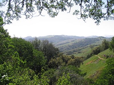
Monte Bello Open Space Preserve
-
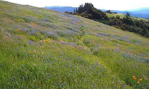
Russian Ridge Open Space Preserve
-
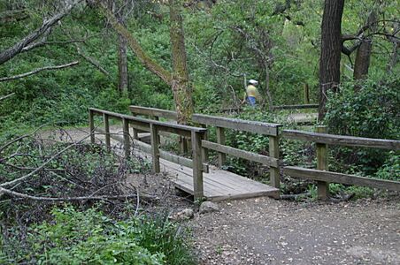
Pulgas Ridge Open Space Preserve


