Mount Wrather (Alaska) facts for kids
Quick facts for kids Mount Wrather |
|
|---|---|

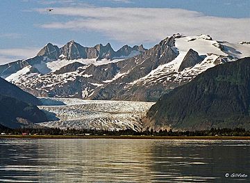
Mount Wrather (right) seen with Mendenhall Glacier and Mendenhall Towers
|
|
| Highest point | |
| Elevation | 5,968 ft (1,819 m) |
| Prominence | 1,268 ft (386 m) |
| Parent peak | Mendenhall Towers |
| Geography | |
| Location | Tongass National Forest Juneau Borough Alaska, United States |
| Parent range | Coast Mountains Boundary Ranges Juneau Icefield |
| Topo map | USGS Juneau B-2 |
| Climbing | |
| Easiest route | Mountaineering |
Mount Wrather is a tall mountain in Alaska, United States. It stands about 5,968 feet (1,819 meters) high. This mountain is part of the Boundary Ranges, which are a group of mountains.
You can find Mount Wrather inside the Tongass National Forest. It's located right next to the famous Mendenhall Glacier. The mountain is about 12 miles (19 km) north of Juneau, Alaska, the capital city. It's also about 9 miles (14 km) north of the Juneau International Airport.
Even though it's not the tallest mountain, Mount Wrather looks very impressive. It rises sharply from sea level near Auke Bay. This means it goes from flat ground to a high peak in a short distance. The mountain was named in 1968 by the United States Geological Survey (USGS). It honors William Embry Wrather, who was the director of the USGS from 1943 to 1956.
Weather and Climbing Conditions
Mount Wrather is in a subarctic climate zone. This means it has very cold and snowy winters. Summers are usually mild, not too hot. Temperatures can drop below -20 °C (-4 °F). With the wind, it can feel even colder, sometimes below -30 °C (-22 °F).
This cold climate helps keep the Mendenhall Glacier on the west side of the mountain. It also supports the large Juneau Icefield to the northeast. If you want to climb Mount Wrather, the best time to go is usually in June and July. These months offer the most favorable weather for mountaineering.
 | Isaac Myers |
 | D. Hamilton Jackson |
 | A. Philip Randolph |


