Mount Zion (Colorado) facts for kids
Quick facts for kids Mount Zion |
|
|---|---|

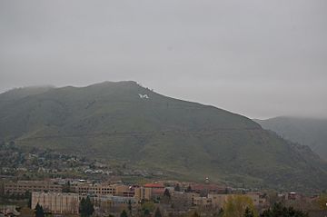
View of Mount Zion from South Table Mountain in the rain.
|
|
| Highest point | |
| Elevation | 7,062 ft (2,152 m) |
| Isolation | 0.29 mi (0.47 km) |
| Geography | |
| Location | Jefferson County, Colorado, U.S. |
| Parent range | Front Range |
| Topo map | USGS 7.5' topographic map Morrison, Colorado |
| Climbing | |
| Easiest route | walk from Lookout Mountain Road (Lariat Loop Road) |
Mount Zion is a smaller mountain, or foothill, located on the eastern side of the Front Range of the Rocky Mountains in North America. This mountain peak is about 7,062 feet (2,152 meters) tall. You can find it inside Windy Saddle Park, which is about 1.7 miles (2.7 kilometers) west of downtown Golden, in Jefferson County, Colorado, United States.
The "M" on Mount Zion
One of the most famous things about Mount Zion is a giant white letter "M" on its side. Students from the Colorado School of Mines take care of this "M".
A Special Tradition
Since 1908, there has been a special tradition for students at the Colorado School of Mines. Every new student (freshman) climbs Mount Zion. They each bring a rock and add it to the "M". This helps to keep the "M" looking good and is a way for students to feel connected to their school. When students graduate, they can take a rock from the "M" with them as a souvenir.
Lighting Up the "M"
The "M" on Mount Zion has been lit up at night since 1932. This makes it a bright and visible landmark, especially for the town of Golden below. It's a symbol of the school and its long history.
 | Bessie Coleman |
 | Spann Watson |
 | Jill E. Brown |
 | Sherman W. White |


