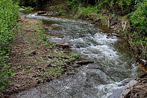
Mugser Run facts for kids
Mugser Run is a stream in Columbia County, Pennsylvania, in the United States. It is about 8 miles (13 km) long. This stream flows into another one called South Branch Roaring Creek. Mugser Run is mostly found in Locust and Cleveland Townships. The land around the stream is mostly covered by forests and farms. You can find brown trout and rainbow trout swimming in its waters.
Contents
Where Mugser Run Flows
Mugser Run begins in Locust Township, close to Pennsylvania Route 42. This is between the towns of Numidia and Little Mountain. The stream first flows west and then enters Cleveland Township.
After entering Cleveland Township, Mugser Run turns south. It briefly goes along the northern edge of Little Mountain before turning north again. It passes by a small community called Fisherdale. Then it turns west, and later north. For a while, the stream flows through a deep, narrow valley. This valley gets wider as the stream passes by an old covered bridge. Just before it ends, Mugser Run flows past Knoebels Amusement Resort. The stream then joins South Branch Roaring Creek near the border of Northumberland County. Mugser Run also has at least one smaller stream that flows into it.
The Land Around Mugser Run
The area of land that drains into Mugser Run is called its watershed. This watershed covers about 11.9 square miles (30.8 square kilometers).
Most of the land in the Mugser Run watershed is covered by forests, making up about 50% of the area. Another large part, about 45%, is used for farming. A small amount, about 4%, is developed land, meaning it has buildings or roads.
The southern edge of the watershed is on Little Mountain. The northern edge is in the rolling hills of Cleveland Township. The western edge is in Locust Township, and the eastern edge is at the Columbia and Northumberland County line.
Many roads are quite close to Mugser Run. For example, a road is within 300 feet (91 meters) of the creek for most of its length.
Water Quality of Mugser Run
Scientists study the water in Mugser Run to understand its health. The average amount of precipitation (rain and snow) in the watershed from 1991 to 2011 was about 39.3 inches (100 cm) per year.
Tiny bits of sediment (like dirt and sand) are carried by the water in Mugser Run. A lot of this sediment comes from farm fields. Some also comes from the stream banks and other developed areas. Forests help to reduce the amount of sediment that flows into the stream.
In the summer of 2006, the water temperature of Mugser Run was measured. It ranged from about 67.5°F (19.7°C) to 72.1°F (22.3°C). The water's pH was slightly acidic, ranging from 6.33 to 6.84. This means it's close to neutral.
Scientists also check for nutrients like nitrogen and phosphorus in the water. These levels can be affected by farming activities nearby. In 2007, Mugser Run was given scores for its health, showing it was in good condition.
Rocks and Soil Around Mugser Run
Mugser Run is located in a region known as the Ridge-and-Valley Appalachians. This area has long, parallel ridges and valleys.
The main rock formations in the Mugser Run watershed are the Trimmers Rock Formation and the Catskill Formation–Buddys Run. These two types of rock make up about 35% of the watershed each. Other rock types, like the Catskill Formation–Irish Valley and the Hamilton Group, are also present.
The soil in the Mugser Run watershed is made up of different types. The most common soil types are the Berks-Weikert-Bedington series and the Leck Kill-Meckesville-Calvin series.
Mugser Run is about 610 feet (186 meters) above sea level.
History of Mugser Run
An old structure called the Johnson Covered Bridge No. 28 crosses Mugser Run. This bridge was built by Daniel Stine for $799. A person named Adam M. Johnson used to own a shoe store near this covered bridge.
Animals in Mugser Run
Mugser Run is known as a trout stream. This means it's a good place for trout to live. The very beginning of the stream is considered "Class A Wild Trout Waters." This is a special designation for streams that have healthy populations of wild trout.
In 1985, brown trout and rainbow trout were added to the stream. Brown trout are quite common in the creek. They come in different sizes, from very small to about 15.7 inches (39.9 cm) long.
Many tiny creatures, called microinvertebrates, also live in Mugser Run. These are small animals without backbones, like insects and worms, that live in the water. Scientists have found many different kinds of microinvertebrates at various spots along the stream. Some types are very common, while others are rare.
The amount of tree cover over Mugser Run, called the canopy, ranges from 50% to 85%. This shade from the trees helps keep the water cool, which is important for trout and other aquatic life.
 | William Lucy |
 | Charles Hayes |
 | Cleveland Robinson |


