Mulgildie facts for kids
Quick facts for kids MulgildieQueensland |
|||||||||||||||
|---|---|---|---|---|---|---|---|---|---|---|---|---|---|---|---|

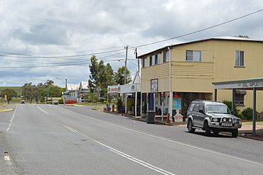
The Burnett Highway passing through Mulgildie, 2017
|
|||||||||||||||
| Population | 147 (2021 census) | ||||||||||||||
| • Density | 2.386/km2 (6.18/sq mi) | ||||||||||||||
| Postcode(s) | 4630 | ||||||||||||||
| Area | 61.6 km2 (23.8 sq mi) | ||||||||||||||
| Time zone | AEST (UTC+10:00) | ||||||||||||||
| Location | |||||||||||||||
| LGA(s) | North Burnett Region | ||||||||||||||
| State electorate(s) | Callide | ||||||||||||||
| Federal Division(s) | Flynn | ||||||||||||||
|
|||||||||||||||
Mulgildie is a small country town in the North Burnett Region of Queensland, Australia. It used to be called Mulgeldie. In 2021, about 147 people lived there. It's known for its quiet, rural lifestyle.
Contents
Discovering Mulgildie's Location
Mulgildie is located about 463 kilometers (288 miles) by road from Brisbane, the capital city of Queensland. The main road that goes through the town is the Burnett Highway. It travels through Mulgildie along Wattle Street and Monal Street.
The land around Mulgildie is mostly used for grazing animals like cattle. Some crops are also grown here.
Mulgildie's Old Railway Station
Mulgildie used to have a railway station. It was part of the old Mungar Junction to Monto railway line. This railway line is no longer used today.
Mulgildie's Past: A Look Back in Time
The town was first named Mulgeldie in 1925. People believe the name comes from an Aboriginal word, bulgeldee. This word refers to a deep waterhole found on Three Moon Creek. The spelling of the town's name was officially changed to Mulgildie in 1945.
Early Services and Communication
A small postal office opened in Mulgildie in 1902, but it closed a few years later. The Mulgildie Post Office then opened properly in 1925. It changed its name to Mulgeldie for a while, then went back to Mulgildie in 1945. It finally closed in 1991.
How Mulgildie's School Began
The railway line reached Mulgeldie in 1927. To build the railway further, workers moved their camp to Mulgeldie. Their children's school, which was just a tent, moved with them. This tent school became Mulgildie Provisional School in September 1927.
In 1928, people decided to build a proper school. A new building was put up, big enough for 40 students. It opened on October 7, 1929. On January 1, 1930, it officially became Mulgeldie State School.
Other Schools in the Area
Two other small schools, Euruga State School (later Aberfeldie State School) and Splinter Creek Bridge State School, also opened nearby. However, they both closed down many years ago.
Community Gathering Places
The Mulgildie Hall, also known as the School of Arts, opened in 1938. This hall has been an important place for community events for a long time.
Mulgildie also had a Presbyterian Church, built in 1950. It is now a private house. St Mark's Anglican Church was built in 1959. It was known for its war memorial. This church also closed down in 2009.
Mulgildie's Population Over Time
The number of people living in Mulgildie has changed over the years.
- In 2006, there were 114 people.
- In 2016, the population grew to 174 people.
- In 2021, the population was 147 people.
Important Historical Sites
Mulgildie has several places that are listed as important historical sites. These include:
- Mulgildie Homestead Cemetery
- Mulgildie Cemetery
- Mulgildie Hall and Park
Learning and Education in Mulgildie
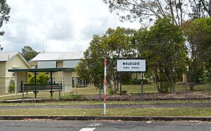
Mulgildie State School is the local primary school for kids from Prep to Year 6. It's a government school for both boys and girls. In 2017, about 25 students attended the school.
There isn't a high school in Mulgildie itself. Students who finish primary school usually go to Monto State High School in Monto, which is the closest secondary school.
What Mulgildie Offers: Local Amenities
The Queensland Country Women's Association (QCWA) has a branch in Mulgildie. They meet at the QCWA Rooms on Pine Street. This group helps women and communities in rural areas.
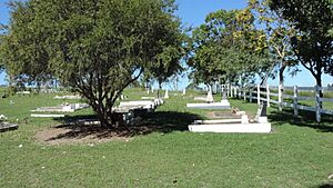
The Mulgildie Cemetery is a place where people are buried. It is located on the Burnett Highway.
The Mulgildie Hall is a busy place in town. People use it for watching movies, holding dances, having meetings, and other community events.
Mulgildie's Famous Attraction: The Bunyip
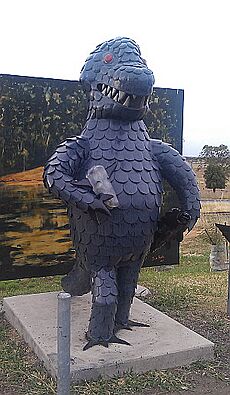
One of the most interesting things to see in Mulgildie is the statue of the Mulgildie Bunyip! It's located on the roadside on Wattle Street.
A bunyip is a mythical creature from Aboriginal folklore. Tourists are encouraged to visit the Bunyip's watering hole, which is about a 10-minute drive from Mulgildie. This place is famous for strange bubbling water and stories of livestock disappearing.
 | Toni Morrison |
 | Barack Obama |
 | Martin Luther King Jr. |
 | Ralph Bunche |


