Mullaghanattin facts for kids
Quick facts for kids Mullaghanattin |
|
|---|---|
| Mullach an Aitinn | |

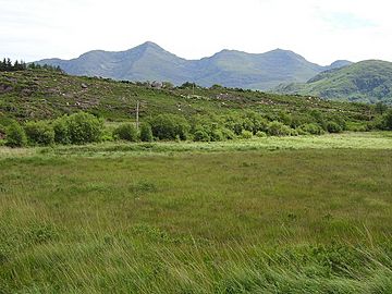
A bog backed by Mullaghanattin
|
|
| Highest point | |
| Elevation | 773 m (2,536 ft) |
| Prominence | 528 m (1,732 ft) |
| Listing | Marilyn, Hewitt |
| Naming | |
| English translation | Summit of the gorse |
| Language of name | Irish |
| Geography | |
| Parent range | Dunkerron Mountains (Mountains of the Iveragh Peninsula) |
| OSI/OSNI grid | V738772 |
| Climbing | |
| Easiest route | scrambling |
Mullaghanattin is a cool mountain in County Kerry, Ireland. Its name comes from the Irish language, Mullach an Aitinn, which means "summit of the gorse." Gorse is a spiky, yellow-flowered bush often found on mountains. Mullaghanattin is part of the Dunkerron Mountains, which are themselves part of the bigger Mountains of the Iveragh Peninsula.
About Mullaghanattin
Where is it?
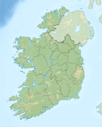
Mullaghanattin is located in the southwest of Ireland. It's in County Kerry, a beautiful area known for its green landscapes. This mountain is part of the Dunkerron Mountains. It sits to the southwest of another mountain called Stumpa Dúloigh.
How tall is it?
Mullaghanattin stands 773 meters (about 2,536 feet) tall. This makes it one of the higher mountains in Ireland. In fact, it's the 58th highest summit in the whole country!
Reaching the Top
Getting There
If you want to climb Mullaghanattin, there's a common way to do it. You can start from a parking area called Tooreennahone. The path begins with gentle slopes, which are easy to walk on.
However, the last kilometer of the climb gets very steep. This part requires a bit more effort and careful footwork. It's a fun challenge for those who enjoy hiking!
 | Laphonza Butler |
 | Daisy Bates |
 | Elizabeth Piper Ensley |


