Mullion Cove facts for kids
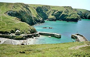
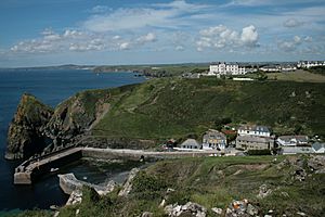
Mullion Cove, also known as Porth Mellin, is a small village on the west coast of the Lizard Peninsula in Cornwall, England. It sits on the eastern side of Mount's Bay. The Cove is part of the parish of Mullion. You can reach it by road from Mullion village, about 1 mile (1.6 km) away. It's also on the popular South West coast path. This beautiful area is part of an Area of Outstanding Natural Beauty.
Mullion Cove is about 5 miles (8 km) south of Porthleven and 14 miles (22.5 km) southeast of Penzance by sea. By land, it's 6 miles (9.7 km) south of Helston and 13 miles (21 km) southwest of Falmouth. In 1937, a 2-mile (3.2 km) stretch of the coast from Mullion Cove to Predannack was protected. This was done with help from the Council for the Preservation of Rural England and the National Trust.
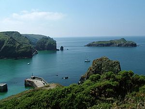
The coast here can be very wild. Strong storms often cross the Atlantic Ocean. Mullion Island, or Enys Pruen, helps protect the Cove from these winds. It lies about 720 yards (658 m) offshore to the southwest. People have lived in the Cove for hundreds of years. In the early 1800s, it had three working Grist Mills. By 1841, the Cove had several fish cellars, net lofts, and two thatched cottages.
Until the early 1900s, Mullion Cove had a busy pilchard seine fishing industry. It was part of the Mounts Bay Fishery. Fishermen also caught crab, lobster, and crawfish. They used traditional Cornish methods with pots made from withy (willow).
Between 1890 and 1897, a harbour was built here. It has two stone piers made mostly from granite and serpentine. Lord Robartes of Lanhydrock helped pay for it. The harbour protected the coast and supported local fishermen, farmers, and traders. A local stonemason maintained the harbour walls each year.
In 1928, Montague Meyer bought the harbour, island, and fish cellars. By 1944, the harbour needed a lot of repairs. In 1945, the Meyer family gave 12 acres (4.9 ha), including the harbour and island, to the National Trust. The Trust took on the repairs and still owns and maintains the harbour today.
In October 1984, three spots in the harbour area became Grade II Listed. This means they are important for their special architecture or history. These include the two harbour walls, the net loft (called a "harbour cottage"), and the nearby Winch House. About 300 yards (274 m) east of the Cove, you can see Criggan Mill. It became Grade II Listed in 1980. It was one of three mills working in the Cove in the 1840s.
The coastal environment has been affected by storms and rising sea levels. Damage has become more serious and costly, especially since 2011. In 2003, the National Trust warned that "Mullion Cove may not stand the ravages of the sea much longer." A 2006 survey also raised doubts about the harbour's future.
Contents
Mullion Cove's Past: A Look Back
One old story from Mullion Cove is about the Spanish Armada in 1588. The Spanish fleet was first seen from the Lizard Peninsula. After the battle, relations with Spain remained difficult. In July 1595, a large Spanish fleet sailed towards Cornwall. Four Spanish galleys attacked Mousehole, Paul, Newlyn, and Penzance. They burned buildings and killed many people. This was the first time in hundreds of years that England had been invaded.
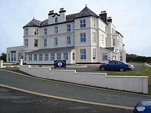
Cornwall was not well-defended back then. This attack led to a "Ring of Fire" warning system. Beacons were set up on high points around the Lizard and Mount's Bay. These were lit to warn of invasion. Mullion Cove, with its great view of Mounts Bay, was chosen as a beacon site. It was near where the Mullion Cove Hotel stands today.
There's a funny story about a night watchman at Mullion Cove. He saw a boat coming in late. Thinking it was the enemy, he shouted, "Who goes here?" The fishermen replied, "Fish and Panniers!" But the watchman misheard it as "French and Spaniards!" He panicked and lit the beacon. Soon, the whole "Ring of Fire" was lit, scaring everyone. It took a while for the truth to come out!
Fishing has been important at Mullion for centuries. A small pilchard fishery started in the early 1700s. By 1793, it grew with new fish cellars. In 1809, an auction notice showed the Mullion Pilchard and Herring Fishery was for sale. It included a new cellar for over 1,200 hogsheads of fish.
By the 1840s, two grist mills in the Cove stopped working. Only one mill at Criggan remained. By 1848, two cottages were built for Coastguard officers. These are now Cove Cottage. An old description of the Cove mentions a mill, fish cellars, and small cottages. It noted that the sun never shone on the cottages in winter.
In 1867, the stream was moved to build a Lifeboat House. In 1868, plans for a harbour were first made. Strong currents and bad weather often trapped ships near the Lizard. Many sailing ships would anchor in the "Mullion Roads" to shelter. This area was between Mullion Island and Pedngwynian.
Shipwrecks and Rescues
The coast of the Lizard Peninsula has a long history of shipwrecks. From the 15th to 19th centuries, locals sometimes took goods from wrecked ships. This was called "wrecking." Wine and spirits were popular items. In 1527, a Portuguese ship called the San Antonio, carrying gold and jewels, was wrecked. Locals took much of its cargo. In 1684, a Dutch cargo ship, the Schiedam, was driven ashore. Locals were again reported to have taken its cargo.
In 1721, a Dutch ship carrying brandy ran ashore. Men were sent to guard it, but locals still removed the cargo. A fire started, injuring some of the people involved. In the early 1800s, many ships passed this coast. French and Spanish privateers (armed ships) often tried to capture them. In 1725, six ships were lost in Mounts Bay during a storm.
In 1817, the Resolution, carrying wine and fruit, was wrecked. Locals attacked the ship, taking property and cargo. Soldiers were sent but couldn't control the crowd. A clergyman wrote about the "rapacity for plundering those wrecks."
The movement against "wrecking" began in the 1740s. John Wesley, a Methodist preacher, spoke out against it. Shipwrecks were often named after their cargo. There was a "Tea wreck" in 1815 and a "Coffee Wreck" in 1832. In 1850, the "Fruit wreck" carried lemons and raisins. In 1667, the "Pin wreck" was found near Mullion Island.
In 1838, an Italian ship, the Silius, carrying salt, ran aground in Mullion Cove. All 15 crew members were believed to have drowned. Eleven were buried in Mullion Churchyard. It was called the "dead wreck." In 1839, about 40 ships anchored near Mullion Island for safety during a gale. Several lost their anchors and were driven ashore. There was no lifeboat, and many crew members were lost.
Between 1859 and 1874, there were 32 shipwrecks between Lizard Point and Porthleven. Most were caused by ships being trapped by winds or colliding with other ships. This showed the great need for better safety.
In 1867, after many shipwrecks and drownings, a meeting was held in Mullion. People called for a lifeboat and a safe harbour. In 1868, plans for Mullion's harbour were sent for approval. There were two ideas: a horseshoe-shaped harbour or a long breakwater. These plans were not built at that time.
In 1889, the harbour plans were brought up again. Lord Robartes provided financial support. The new plans were for two stone piers. The west pier was built first, starting in 1891. It was finished in December 1892. The south pier was built later, starting in 1895.
Most of the stone came from nearby. Granite came from Penryn quarries. Over 2,000 tons of cement were used. Skilled stonemasons and workers came from all over Southwest England. The harbour was finally finished in late 1897. Lord Robartes invested about £15,000 in the project.
Nature and Rocks at Mullion
The main rocks around Mullion Harbour are hornblende schist. This rock was changed by heat and pressure from other rocks. South of the harbour, you can see serpentine rock. This rock is visible in the high Mullion Cliffs. In 1752, these cliffs were a quarry for a mineral called talc, or soapstone.
This mineral was taken from several sites along the Lizard Peninsula for about 80 years. It was used by early English porcelain factories. This allowed them to make strong, heat-resistant pottery. Before this, porcelain often cracked when hot water was poured into it. This new material helped England compete with porcelain from China.
Soaprock was first found in the 1720s. Its high magnesium content and fine texture made it perfect for ceramics. Once removed from the cliffs, it was sorted and sent by sea to factories in Bristol, Worcester, and London.
The serpentine cliffs on the south side of Mullion Cove have a rich history. Serpentine is a common rock on the Lizard. It often has faults and intrusions of other materials. These areas sometimes contain valuable minerals.
One important mineral was native copper. It was found in the 1720s at Predannack. A local man, Richard Hall, found it when his horse kicked up a piece of copper ore. Although small amounts were found in the Cove, it was mined underground nearby. The first mine was called Wheal Ghostcroft.
The first copper mining here lasted only a few years. It reopened as Wheal Providence in the 1740s. It produced a lot of copper ore. It reopened again between 1807 and 1811 as Wheal Unity. It produced very large sheets of native copper. Some were so big they were sold as curiosities. One piece was exhibited at the Great Exhibition in London in 1851. It is still in the Natural History Museum.
The faults in the rock also created some of the largest caves on the Lizard. Victorian tourists loved to explore them at low tide. The main cave is called Torchlight Cave. It's unusual because it lies on a fault line. Inside, it's clear that it was partly made by people. Victorians used gorse torches to see their way.
This cave was used for underground soaprock mining. It was also used to store contraband like brandy by smugglers. For many years, people thought these caves were tunnels to take water from the copper mines. But they are separate. The copper mine tunnels led north to a river that flows into the Cove.
Torchlight Cave is harder to reach now. You can only get there for short times during the lowest tides. This shows that sea levels are rising, which is important for the future of Mullion Harbour.
Fishing and Smuggling Stories
A fishing industry has been in Mullion Cove for hundreds of years. In the 1600s, fishing boats and their crews were sometimes captured by pirates. In 1636, seven fishing boats from the area, including one from Mullion, were taken by Turkish pirates. About 50 men were captured.
Smuggling was common among Lizard fishermen. It was a way to make extra money by avoiding taxes. A barrel of brandy from France was a welcome sight. In April 1786, a smuggler named Thomas Welland was killed in a gun battle near Mullion Island.
A famous story from 1801 tells of the Revenue gunship Hecate capturing a lugger with smuggled spirits in Mullion Cove. Locals, led by William Richards, raided a militia armoury. They took muskets and fired at the Revenue men from the cliffs. The Revenue men had to leave the lugger. The Admiralty offered a £100 reward for Richards.
William Richards, also known as "Billy the Payow," was described as 52 years old, 5' 7" tall, with dark hair and a thick red beard. A King's Pardon was offered to anyone who helped catch the others, except Richards. Nothing was reported about Richards, but a man with the same name later helped rescue sailors from the shipwreck of HMS Anson in 1807.
Smuggling continued for many years. In 1897, two old smugglers, Henry "Bo Bo" George (78) and Dionysius Williams (93), shared their stories. A four-gallon (18 litres) tub of brandy bought in France for £1 could sell for £4 in Mullion. Henry George, known as "The King of the Smugglers," made 21 trips to France for brandy. Smugglers planned their trips carefully, always having backup landing spots. They avoided bloodshed, but both sides were armed. There were hiding places in almost every house.
Pilchard fishing was vital for many Cornish families. It provided income and food. Fishermen also made their own fishing pots from willow. This skill is now rare.
In 1793, Mullion Cove fishermen asked for permission to develop a pilchard fishery. By 1805, much of the pilchard catch was taken to Penzance and Newlyn to be cured. In 1806, 7,000 hogsheads of pilchards were caught from Mullion.
"Huers" were important in the fishing industry. They were lookouts who stood on the headland, like at Henscath. They would shout "Hevva!" when they spotted a pilchard shoal. They directed the boats to the best spots to cast their nets. The Huer worked from sunrise to sunset, six days a week.
In 1811, pilchards from Mullion were sold cheaply in Penzance. In the early 1800s, fish were plentiful. The main market for Cornish pilchards was in the Mediterranean, especially Italy. By 1850, fewer fish were caught. The pilchard season declined. In 1859, the shoals didn't appear at all. By 1877, fishing was in decline.
Most major fishing companies were based at Newlyn, with boats at Mullion. They were part of the Mounts Bay fishing industry. Seine boats were heavy oak crafts, 30 to 40 feet (9 to 12 m) long. They were rowed by six crewmen. The Huer directed them to circle the fish with nets. Each boat had a specific "area of ground" to cast their nets.
A second boat, the "Volyer," carried a "Tuck Net" to remove fish from the main net. A smaller boat, the "Lurker," held the Master Seiner. The large seine nets could be 1,200 feet (360 m) long and 60–70 feet (18–21 m) deep. After catching, the fish were salted in fish cellars and sent abroad.
When bad weather came, the heavy seine boats were pulled out of the water using a strong winch. A capstan, like the one seen in Mullion Cove today, was used. Fishermen's pay varied. Fishing companies, boat owners, and fishermen each got a share of the profits.
For centuries, keeping lobsters and crabs fresh was a challenge. In the 19th century, boats from the Isles of Scilly would collect lobsters and crabs from Mullion Cove. They took them to Southampton in special containers filled with seawater. Prices varied, but lobsters sold for about 14 shillings per dozen.
Storms often damaged fishing boats. In July 1839, a storm almost destroyed Mullion's pilchard fleet. Six seine boats sank, and most nets were lost. This was a huge loss.
In 1858, Dionysius Williams of Mullion sent crabs and lobsters to London by steamer and train. This was one of the first times this was done. Later that year, his boat sank near Fowey while carrying a catch. Dionysius Williams was a fisherman, carpenter, and smuggler. He lived to be 94 and was a respected member of Mullion Parish.
By 1919, low prices in London were hurting the lobster and crab fishermen. The fishing industry faced tough times.
In 1878, two American brothers, William and Asa Walter Andrews, sailed across the Atlantic in a small boat called the Nautilus. They landed in Mullion Cove after 45 days. This was the fastest crossing ever by a small boat. Crowds came to see them, and newspapers interviewed them. They stayed at the "Old Inn" and met locals. They wrote that their arrival was "the only event that has happened here outside shipwrecks for many years."
In 1850, there were three types of fishing in Mounts Bay: drift net, seine fishing, and "Hookers" (using long lines with many hooks). Drift fishing was most common. At night, Mounts Bay was described as a "City of Twinkling Lights" from all the fishing boats.
Storms often caused tragedies. In October 1880, a severe storm hit Mounts Bay. Thirty fishing boats were lost, and many lives were lost. This was one of the worst disasters recorded. This disaster, and others, helped push for the harbour to be built at Mullion Cove.
Like many fishing villages, Mullion held an annual regatta. Hundreds of locals and visitors watched sailing, rowing, and swimming races. These events were popular in the 1890s. But in 1894, a local man drowned when his boat sank during the regatta.
Even after the harbour was built, fishing faced challenges. In April 1899, a hurricane-force storm hit Mounts Bay. Fourteen fishing boats were driven from their moorings. Some drifted out to sea, and others were wrecked. One 71-year-old fisherman, William Treneer, was asleep on his boat Alpha when it was swept away. Miraculously, he was later found alive after drifting out to sea and being picked up by a Hungarian steamer.
Mullion Cove in the 20th Century
Tourism became important to Mullion Cove in the late 1800s. New rail and road links brought thousands of tourists. Three large hotels were built in Mullion: Polurrian House Hotel (1889), Mullion Cove Hotel (1898), and Poldhu Cove Hotel (1899). Artists often painted the scenery. Regattas continued, and visitors enjoyed boat trips and swimming to Mullion Island.
In 1905, summer storms destroyed boats and fishing gear. Famous actors and authors staying at the hotels helped raise money for the fishermen. Sometimes, village cricket matches were stopped by the "Hevva" call, as all fishermen ran to launch their boats.
For hundreds of years, the Italian market bought most of Cornwall's pilchards. But in 1909, an earthquake in Messina, Italy, affected the market. In Britain, salted pilchards were not popular. The market was changing. World War I also brought more efficient engines for fishing boats.
By the early 1920s, seine boats began to disappear. In 1923, Italy made it harder to sell pilchards there. By the late 1920s, there was too much fish, and catches had to be dumped. By 1935, Italy banned imports of pilchards from the UK. By 1939, Britain was importing canned pilchards from California and Japan. No one wanted Cornish pilchards anymore.
In the 1920s and 1930s, only a few Mullion boats were involved in fishing. Fishing became harder. World War II in 1939 ended pilchard fishing. The markets and fishermen never fully recovered.
The decline of pilchard fishing led to a new era for motorised fishing boats. They could travel farther and bring fresher catches to market faster. This also meant that boats from France and other European countries could fish in the English Channel. French fishermen sometimes used the Grade II Listed Net Loft in Mullion Harbour as shelter during storms.
In the late 1920s, the Meyer Family owned the Harbour. But storms caused damage again. In November and December 1929, three huge Atlantic storms hit Cornwall. They caused widespread damage to sea walls and harbours. Winds reached 90 mph (145 km/h) in Falmouth. Photographs from the early 1930s show the south pier gradually falling apart.
During World War II, an anti-tank wall was built in Mullion Cove. It was 5 feet (1.5 m) high and 4 feet (1.2 m) wide. About half of it still exists. Barbed wire was also added to the harbour walls. Maintenance of the harbour was difficult during the war. Skilled stonemasons were scarce. By 1944, the south pier was collapsing. Fishermen refused to pay harbour dues.
In 1945, the National Trust took over the harbour. They initially thought repairs were too expensive. But they felt it was their duty to fix it for its beauty. In 1947, the west pier was also in danger. The Trust launched an appeal to raise £2,000 for repairs.
Repairs continued over the years. In 1954, part of the southern pier fell away. It was later cut and capped with concrete. In 1978, cracks appeared, and the seaward end was rebuilt with serpentine and granite. In the 1990s, the concrete walkway was rebuilt, and rock armour was added. These repairs cost hundreds of thousands of pounds.
By 2003, the National Trust was worried about the harbour's future. A 2006 report said the outlook for the next 100 years was not good. It warned that climate change, rising sea levels, and increasing costs might lead to the piers collapsing. The Trust considered "managed retreat," meaning they might remove the breakwaters or let them collapse.
In 2008, a National Trust document highlighted that coastal erosion could affect 173 miles (279 km) of their coastline. They aimed to "work with natural processes."
In 2011, storms damaged both piers again. More concrete was added. In 2013–14, a series of severe winter storms caused huge damage. Waves were higher than anyone had seen before. Beaches lost up to 6 feet (2 m) of sand. The Daily Mirror even featured a front-page story of a man and child being engulfed by waves at the harbour.
Repairs were done in two phases. In May 2014, lost granite stones were replaced. This included heavy granite blocks weighing 2-3 tons. The second phase, on the south pier, used modern marine concrete.
In 2016, the National Trust reported spending over £2 million since 1945 on repairs. They spend an average of £1,500 per week due to frequent storms. The harbour receives 80,000 visitors per year.
Lifeboat Station: Saving Lives at Sea
As early as 1811, people suggested having a Lifeboat at Porthleven and Mullion Cove. By the late 1850s, after many shipwrecks and lives lost, villagers and Lloyd's of London agreed a lifeboat was needed. The RNLI also agreed in 1859. Lord Robartes helped with funding. The closest lifeboats were at Porthleven and Lizard Point.
In early 1867, a series of severe storms caused 16 shipwrecks in the Penzance area. Three schooners were wrecked near Mullion and Poldhu, with four lives lost. Villagers in Mullion held a meeting, calling for a lifeboat. The RNLI responded, and funds were raised. Shortly after, in March 1867, a Dutch ship, the Jonkheer Meester van de Wall van Putterschoek, was wrecked near Mullion. Twenty-four lives were lost, with only one survivor.
On September 13, 1867, a self-righting lifeboat named Daniel J Draper arrived from London. It was stationed in a new lifeboat house. On its first launch, October 21, 1867, the crew saved three lives from the wreck of the Achilles. The Coastguard also helped rescue 14 more sailors using a rocket apparatus.
Tragically, on April 19, 1872, Mullion's First Coxswain, William Mundy, drowned. His 18-foot sailing boat sank off Porthleven. His two sons and a carpenter were with him. There is a memorial cross for Henry Mundy in Mullion parish church.
Between 1867 and 1887, the Daniel J Draper responded to 14 calls. It was replaced by the Edith in 1889, and then by the Nancy Newbon in 1897. Sometimes, storms were too strong for the lifeboat to go out. In 1908, the lifeboat was removed from Mullion. The station officially closed on July 3, 1908.
The rocket apparatus along the Lizard Coast was very important. It saved more lives than the lifeboat. The Coastguard and local men always helped when called. They showed great bravery and teamwork in terrible conditions.
Even without a lifeboat, Mullion Cove remained important. In December 1932, 84 cargo ships had to shelter in the Mullion Roads during strong gales. They needed to restock food supplies from the village shops. Luckily, no ships were lost. This showed that even with modern engineering, the sea and weather in Mounts Bay could still be a challenge.
 | Lonnie Johnson |
 | Granville Woods |
 | Lewis Howard Latimer |
 | James West |


