Museum of Lands, Mapping and Surveying facts for kids
The Museum of Lands, Mapping and Surveying is a cool museum in Brisbane, Queensland, Australia. You can find it at 317 Edward Street. This museum is all about how Queensland was mapped and measured. It shows how people explored the land and created maps. The museum is part of the Queensland Museum family. It also turns old maps and aerial photos into digital files. This makes them easy for everyone to see and use for free.
Contents
What the Museum Collects
Exploring and mapping land was super important for Queensland to grow. Surveyors and cartographers (map makers) helped set the state's borders. They measured the land and created many maps. They also made survey plans and records.
The museum collects and shows these important items. They help us understand how Queensland developed. The museum has a great collection, even though it hasn't been around for a super long time. It holds many key maps, plans, and old tools. These items show the history of mapping, surveying, and land use in Queensland.
The museum finds, saves, lists, and displays information. It also shows old tools related to land settlement, surveying, and map-making in Queensland.
How the Museum Chooses Items
The museum tries to find old records, tools, maps, and plans. These items help fill in missing parts of Queensland's mapping history. The goal is to make this knowledge easy for everyone to find. New items are always being found that are important for research.
Historical Treasures
The museum has many items you can see in person or online. These include:
- Old maps and plans
- Historical photos
- Pictures taken from the air
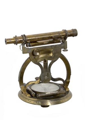
- Old tools and objects
- Stories about surveyors and map makers
- Important papers (like early Queensland Treasury rental sheets)
- Books and other writings
Museum History
In 1982, the Queensland Government decided to create a museum. The Surveyor General of Queensland, JM Serisier, wanted to save the history of mapping and surveying. The first museum was in the Lands Administration Building. This building is now the Conrad Treasury Hotel. Bill Kitson was given the job of setting up and running the museum.
With help from the government and mapping groups, Kitson started collecting old tools. These tools were quickly disappearing as new technology came along. The museum's collection grew. It started with just tools. Then it added diaries, artwork, photos, and life stories. These items showed the personal side of mapping and surveying. Many old maps of Queensland were also collected.
In 1987, the museum moved to a new building called the Landcentre. This building is in Woolloongabba.
In 1988, an agreement was made with the Queensland Museum. The Queensland Museum agreed to look after the collections. The government still provides staff to manage the museum. This helped make sure the old items were kept safe.
In 1991, the museum's focus became wider. It was renamed the Museum of Lands, Mapping and Surveying. This new name included the history of land development in Queensland.
In 2018, the museum moved again. Its new home is at 317 Edward Street in the Brisbane CBD.
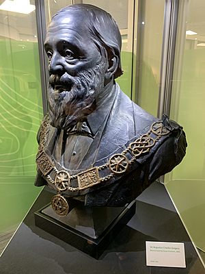
In late 1905, a sculptor named Oscar Fristrom made a statue. It was a bust of Augustus Charles Gregory. He was the first Surveyor-General of Queensland. In 1906, Fristrom offered to sell the bust. He offered it to the Royal Geographical Society of Queensland. But the society decided not to buy it. They did show it at an event in June 1906. For many years, the bust was displayed in Cairns. It was at a Freemasons’ lodge named after Gregory. Gregory is shown wearing his Masonic regalia (special clothes). In 2018, the Freemasons gave the bust to the museum. Today, you can see the bust at the entrance of the museum.
See also
- Surveying in Australia
 | James Van Der Zee |
 | Alma Thomas |
 | Ellis Wilson |
 | Margaret Taylor-Burroughs |


