
Mynydd Epynt facts for kids
Quick facts for kids Mynydd Epynt |
|
|---|---|
 View east from Blaen Bwch Farm |
|

Mynydd Epynt
|
|
| OS grid reference | SN 961464 |
| Principal area | |
| Ceremonial county | |
| Country | Wales |
| Sovereign state | United Kingdom |
| Police | Dyfed-Powys |
| Fire | Mid and West Wales |
| Ambulance | Welsh |
| EU Parliament | Wales |
Mynydd Epynt is an upland area in Powys, Wales. It used to be a small community.
In 1940, the Ministry of Defence (MOD) made the people living there move out. This was a big and sad event called the Epynt clearance. The MOD then turned the area into a large military training zone. It is now known as the Sennybridge Training Area (SENTA), which is the biggest military training area in Wales.
Contents
What Does Mynydd Epynt Mean?
The name Mynydd Epynt is Welsh. Mynydd means "mountain" or "upland area." The meaning of Epynt is a bit less clear.
Many people think Epynt means "a pathway for horses." This idea comes from an old word for "horse." Another idea is that it means a place where a path "rises sharply."
These ideas suggest that Mynydd Epynt has always been a place with important paths. These paths were used for travel and moving animals, like drovers' roads, for a very long time.
A Look Back: History of Mynydd Epynt
Ancient Times: Prehistory
_(cropped).jpg)
People have been interested in the history of Mynydd Epynt for a long time. As early as 1809, a historian named Theophilus Jones wrote about old stone circles and other structures found there.
Today, archaeologists have studied these sites. They found many features from the Bronze Age, which was thousands of years ago. These include old enclosures, cairns (piles of stones), and stone circles.
These ancient sites show that people lived and built things in Mynydd Epynt over many different periods. Some older structures were even used or respected by later groups. Many of these monuments are found near the old trackways, especially where paths crossed.
Life in the Community
The community of Mynydd Epynt has been active since at least the Medieval period. Old field systems, where people farmed, can still be seen today.
The area's important trackways led to four inns being built on the northern side of Mynydd Epynt. These were places where drovers (people who moved animals) could stop. One of these, The Drover's Arms, is now part of the Sennybridge Training Area (SENTA). Even though it's used for military training, its outside was fixed up in the 1990s.
The people of Mynydd Epynt spoke Welsh. They had a school, a church, and many chapels. They held cultural events like Eisteddfodau (poetry and music festivals) and Gymanfa Ganu (singing festivals). A special custom was to put out a white sheet if a family needed help. This was a signal, and others in the community would come to offer their support.
The Military Takes Over
In 1940, during World War II, the MOD decided they needed Mynydd Epynt for military training. They made all the families living there move out. This was a very difficult time for the community.
About 250 people from 54 farms and homes had to leave their land. They were given money for their properties, but many did not want to go. This event is known as the Epynt clearance.
Changes and New Paths

Military training has destroyed most of the original buildings in Mynydd Epynt, including chapels and their cemeteries. However, in 1988, the army built a fake village. This "Fighting In Built Up Areas" (FIBUA) zone has mock buildings, even a fake chapel with imitation gravestones, for training purposes.
Since the 1990s, the army has made the training area even bigger. Most of Mynydd Epynt now has restricted access because live ammunition and explosives are used. Even though the land is used for training, sheep still graze there.
One of the homes bought in 1940, called Disgwylfa, was fixed up in the 1990s as a conservation center. It was opened again in 2009 as Canolfan Epynt, which means the Epynt Centre.
Even though the old paths across Mynydd Epynt are closed, the MOD created a new long-distance path in 2004. The Epynt Way goes around the edge of the training area. It's a circular route for walkers, horse riders, and mountain bikers to enjoy the area safely.
The area was also used for the Wales Rally GB car race from 2006 to 2008.
Where is Mynydd Epynt?

Mynydd Epynt is a large, flat area of land between 400 and 450 meters high.
- To the south, it's next to the Usk Valley and the Brecon Beacons National Park.
- To the north, it's near the Irfon valley.
- To the east, it's by the valley of the River Wye.
- Its western edge is less clear but is east of the A483 road.
Several rivers flow from Mynydd Epynt. Some flow south into the River Usk, like the Cilieni and Nant Bran. The Duhonw river flows northeast into the River Wye. The highest point in Mynydd Epynt is 478 meters high.
Welsh TT Motorcycle Races

From 1948 to 1953, Mynydd Epynt was used for yearly motorcycle road racing. In 2017, a new group wanted to bring road racing back to the area.
They planned to use a 5.25-mile circuit on private paved roads within the military area. These were the same roads used for the historic Eppynt Motor Cycle Road Races.
The races were planned for August 2018 but were cancelled because of problems with Welsh road laws. They were then postponed until 2019. Unlike the Isle of Man TT races, which are free to watch, tickets were being sold for the Mynydd Epynt event.
The organizers included famous racers like Jenny Tinmouth and Steve Plater.
Images for kids
-
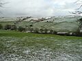
View east from Blaen Bwch Farm
-
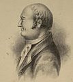
Theophilus Jones described the area of Mynydd Epynt, including its ancient monuments
-
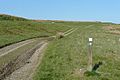
The Epynt Way path
-
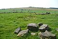
The summit of Mynydd Epynt
-
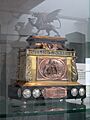
Welsh TT races Trophy, originally awarded for races on Pendine Sands, later for races held on the Epynt hard roads
