
Māngere Mountain facts for kids
Quick facts for kids Māngere Mountain |
|
|---|---|

Māngere Mountain seen from Ambury Regional Park
|
|
| Highest point | |
| Elevation | 106 m (348 ft) |
| Geography | |

Māngere Mountain
Location in New Zealand
|
|
| Geology | |
| Volcanic arc/belt | Auckland volcanic field |
Māngere Mountain is a cool volcanic cone located in Māngere, Auckland, New Zealand. It's one of the largest volcanoes in the Auckland volcanic field. This mountain stands about 106 meters (348 feet) above sea level. It was once a very important pā, which means a fortified village for Māori communities. You can still see many parts of these old settlements today! From the top, you get amazing views of Auckland. The mountain is also known by its Māori name, Te Pane o Mataoho.
What is Māngere Mountain?
Māngere Mountain is a special type of hill formed by a volcano. It's part of a group of volcanoes in Auckland. This mountain has two large craters. One crater is wide and has a unique lava dome in its center. No other volcano in Auckland has a feature quite like this! Scientists believe the volcano first erupted around 70,000 years ago.
A Well-Preserved Volcano
Māngere Mountain is one of the biggest and best-preserved volcanic cones in Auckland. This means it still looks a lot like it did a long time ago. Many interesting archaeological features remain on the mountain. These include:
- Kumara pits: These were special holes used to store kumara, a type of sweet potato.
- Garden terraces: These are flat steps built into the hillside for growing crops.
- Walled garden mounds: These were raised garden beds surrounded by stone walls.
- Stone boundary walls: These walls marked the edges of different areas or properties.
These features show us how people lived and farmed on the mountain many years ago.
Nearby Mangere Lagoon
Close to Māngere Mountain, to the southwest, you'll find Mangere Lagoon. This lagoon is actually another volcanic crater that has filled with water. It's a cool example of how volcanoes can shape the land around them.
Images for kids
-

The central lava dome, or tholoid, inside the crater.
-
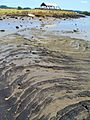
Pahoehoe lava flow from Māngere Mountain at nearby Ambury Regional Park.
-
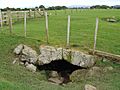
One of many small lava caves found in the lava flows from Māngere Mountain, at Ambury Regional Park.


