
Naganuma, Hokkaido facts for kids
Quick facts for kids
Naganuma
長沼町
|
|||
|---|---|---|---|
|
Town
|
|||

Naganuma Town hall
|
|||
|
|||

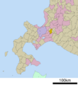
Location of Naganuma in Hokkaido (Sorachi Subprefecture)
|
|||

Naganuma
Location in Japan
|
|||
| Country | Japan | ||
| Region | Hokkaido | ||
| Prefecture | Hokkaidō (Sorachi Subprefecture) | ||
| District | Yūbari | ||
| Area | |||
| • Total | 168.36 km2 (65.00 sq mi) | ||
| Population
(September 30, 2016)
|
|||
| • Total | 11,262 | ||
| • Density | 66.892/km2 (173.250/sq mi) | ||
| Time zone | UTC+09:00 (JST) | ||


Naganuma (長沼町, Naganuma-chō) is a cool town found in Hokkaidō, Japan. It's located in an area called Sorachi Subprefecture.
Contents
About Naganuma
Naganuma is a town in the northern part of Japan. It's part of Hokkaidō, which is Japan's second-largest island. The town is known for its beautiful natural surroundings.
Where is Naganuma?
Naganuma is located in the Sorachi Subprefecture of Hokkaidō. It's also part of the Yūbari District. This area is in the central part of Hokkaidō.
How Big is Naganuma?
The town of Naganuma covers an area of about 168 square kilometers. That's roughly 65 square miles. It's a pretty good size for a town!
Who Lives in Naganuma?
As of September 30, 2016, about 11,262 people lived in Naganuma. This number changes over time, but it gives you an idea of the town's population.
Symbols of Naganuma
Like many towns, Naganuma has its own special symbols. These include a flag and a seal. They help represent the town's identity.
Getting Around Naganuma
Naganuma uses JST, which is 9 hours ahead of Coordinated Universal Time (UTC). This is the standard time across Japan.
Images for kids
-

Naganuma Town hall
-
Map showing Naganuma in Hokkaido
