Nagri Totial facts for kids
Quick facts for kids
متجر جالك
|
|
|---|---|

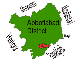
Location of Nagri Tutial (highlighted in red) within Abbottabad district, the names of the neighbouring districts to Abbottabad are also shown.
|
|
| Country | |
| Province | |
| District | Abbottabad |
| Tehsil | Lora |
| Population
(2017 Census of Pakistan)
|
|
| • Total | 12,623 |
Nagri Totial, also known as Nagri Tutial, is an important area in Abbottabad District in Khyber Pakhtunkhwa province, Pakistan. It is one of the 57 "union councils" in the district. A union council is like a small local government area.
About Nagri Totial
Nagri Totial is sometimes called "the town of the Tutials." It got its name from a local chief named Raja Toota Khan. He was a son of Doomat Khan, who belonged to the Dhund tribe.
The village is located quite high up, at about 1,243 meters (4,081 feet) above sea level. The Haro River flows right through the village, adding to its natural beauty.
A Look at History
Nagri Totial has an interesting past. Before India and Pakistan became separate countries in 1947, people from different religions lived together peacefully. Both Hindus and Sikhs lived alongside Muslims. However, after the partition, many Hindus and Sikhs moved to India.
Most people living in Nagri Totial today are from the 'Totialian' branch of the Dhund (Abbasi) tribe. They are descendants of Raja Toota Khan. These families live in an area that stretches from southeast of Abbottabad all the way to Ghora Gali, near Murree. Some other groups, like the Qureshis, Awans, and Bhattis, also live in the village.
The closest town to Nagri Totial is Lora, and you can easily get there by road.
Where is Nagri Totial?
Nagri Totial is located in the southeastern part of the Abbottabad District. It sits right on the border with the Punjab province of Pakistan. Its eastern side touches Rawalpindi, which is a "tehsil" (a smaller administrative division) in Punjab.
Nagri Totial shares its borders with other union councils within Abbottabad District:
- To the north and east, it borders Seer Gharbi.
- To the west, it borders Nara.
- To the south, it borders Lora.
 | William L. Dawson |
 | W. E. B. Du Bois |
 | Harry Belafonte |

