Nahta Cone facts for kids
Quick facts for kids Nahta Cone |
|
|---|---|

Nahta Cone
|
|
| Highest point | |
| Elevation | 1,690 m (5,540 ft) |
| Prominence | 45 m (148 ft) |
| Geography | |
| Location | British Columbia, Canada |
| Parent range | Spectrum Range |
| Topo map | NTS 104G/07 |
| Geology | |
| Age of rock | Holocene |
| Mountain type | Cinder cone |
| Volcanic arc/belt | Northern Cordilleran Volcanic Province |
| Last eruption | Holocene |
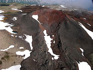
Nahta Cone is a special type of volcano called a cinder cone. It is found in northern British Columbia, Canada. This cone is about 69 kilometers (43 miles) southwest of a place called Tatogga. It's also about 9 kilometers (6 miles) north of Wetalth Ridge. You can find Nahta Cone in the southwestern part of Mount Edziza Provincial Park.
History of Nahta Cone
Nahta Cone got its name on January 2, 1980. The Geological Survey of Canada decided to name it. They chose the name to honor the last seven people of the Wetalth group. The Wetalth were a group of people who had been separated from the larger Tahltan people a long time ago. The word "Nahta" actually means "seven" in the Tahltan language.
Geology of Nahta Cone
Nahta Cone is one of the newest volcanic features in the Spectrum Range. The Spectrum Range is part of a bigger area called the Mount Edziza-Spectrum Range volcanic complex. This whole area is also part of an even larger chain of volcanoes called the Northern Cordilleran Volcanic Province.
Nahta Cone formed during the Holocene period. This is the most recent geological time period. A cinder cone is a volcano that is usually cone-shaped. It is built from small pieces of rock and ash that erupt from a single vent. These pieces are called cinders. They pile up around the vent, creating the cone shape.
 | Dorothy Vaughan |
 | Charles Henry Turner |
 | Hildrus Poindexter |
 | Henry Cecil McBay |

