Nanticoke, New York facts for kids
Quick facts for kids
Nanticoke, New York
|
|
|---|---|
| Motto(s):
The biggest little town in Broome County
|
|

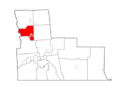
Map highlighting Nanticoke's location within Broome County.
|
|
| Country | United States |
| State | New York |
| County | Broome |
| Government | |
| • Type | Town Council |
| Area | |
| • Total | 24.36 sq mi (63.09 km2) |
| • Land | 24.27 sq mi (62.86 km2) |
| • Water | 0.09 sq mi (0.23 km2) |
| Elevation | 1,391 ft (424 m) |
| Population
(2010)
|
|
| • Total | 1,672 |
| • Estimate
(2016)
|
1,604 |
| • Density | 66.09/sq mi (25.52/km2) |
| Time zone | UTC-5 (Eastern (EST)) |
| • Summer (DST) | UTC-4 (EDT) |
| FIPS code | 36-007-49396 |
| GNIS feature ID | 0979247 |
Nanticoke is a small town located in Broome County, New York, in the United States. In 2010, about 1,672 people lived there.
The town gets its name from the Nanticoke people. They were a Native American tribe. Their original home was near Chesapeake Bay. Nanticoke is on the western edge of Broome County. It is also northwest of the city of Binghamton.
Contents
History of Nanticoke
Early Settlements
People from Europe first started settling in the Nanticoke area around 1793. The town of Nanticoke was officially created in 1831. It was formed from a larger town called Lisle.
Growth of Villages
Two small villages grew up in the area. These were Glen Aubrey and Nanticoke. They developed around important businesses like flour and lumber mills. These mills helped the early settlers build their homes and get food.
The Nanticoke People's Journey
The Nanticoke people, for whom the town is named, had a long journey. They were moved from their home in Chesapeake Bay. First, they were pushed to Nanticoke, Pennsylvania. This place is south of Nanticoke, New York. Later, they were moved again. They resettled further north in Nanticoke, Ontario.
Geography of Nanticoke
Land and Water Area
Nanticoke covers a total area of about 63.1 square kilometers (24.4 square miles). Most of this area is land, about 62.9 square kilometers (24.3 square miles). Only a small part, about 0.2 square kilometers (0.09 square miles), is water.
County Borders and Roads
The western edge of Nanticoke forms the border with Tioga County. A main road, New York State Route 26, runs through the town. It goes from north to south.
Local Waterways
A stream called Nanticoke Creek flows through the town. It travels south from Nanticoke. Eventually, it reaches the Susquehanna River.
Population and People
Population Changes Over Time
| Historical population | |||
|---|---|---|---|
| Census | Pop. | %± | |
| 1840 | 400 | — | |
| 1850 | 576 | 44.0% | |
| 1860 | 797 | 38.4% | |
| 1870 | 1,058 | 32.7% | |
| 1880 | 999 | −5.6% | |
| 1890 | 723 | −27.6% | |
| 1900 | 666 | −7.9% | |
| 1910 | 536 | −19.5% | |
| 1920 | 444 | −17.2% | |
| 1930 | 454 | 2.3% | |
| 1940 | 546 | 20.3% | |
| 1950 | 627 | 14.8% | |
| 1960 | 794 | 26.6% | |
| 1970 | 1,020 | 28.5% | |
| 1980 | 1,425 | 39.7% | |
| 1990 | 1,846 | 29.5% | |
| 2000 | 1,790 | −3.0% | |
| 2010 | 1,672 | −6.6% | |
| 2016 (est.) | 1,604 | −4.1% | |
| U.S. Decennial Census | |||
The population of Nanticoke has changed over many years. In 1840, there were only 400 people. The population grew steadily for a long time. It reached its highest point in 1990 with 1,846 residents. By 2010, the population was 1,672 people.
Who Lives in Nanticoke
In 2000, there were 1,790 people living in Nanticoke. Most residents were White. A small number of people were African American, Native American, or Asian. Some people identified with two or more races. About 0.84% of the population was Hispanic or Latino.
Many households in Nanticoke had children under 18. Most families were married couples living together. The average household had about 2.85 people. The average family had about 3.20 people.
Age Groups in Town
The population of Nanticoke includes people of all ages. In 2000, about 30.4% of residents were under 18 years old. About 30.9% were between 25 and 44 years old. About 8.9% of the population was 65 years or older. The average age in Nanticoke was 35 years.
Communities and Locations in Nanticoke
Nanticoke has several smaller communities and interesting spots:
- Glen Aubrey – This is a small village or hamlet. It is in the southern part of the town. You can find it along New York State Route 26. It used to be known as the "Councilman Settlement."
- Greenwood Park – This is a county park. It is located near the western border of the town. It's a great place for outdoor activities.
- Nanticoke – This is the main hamlet of Nanticoke. It is in the western part of the town. It was once called "Lambs Corners." This community is where County Roads 21 and 136 meet.
- Nanticoke Springs – This was a community in the past. It was located southeast of the Nanticoke village.
See also
 In Spanish: Nanticoke (Nueva York) para niños


