Nanticoke Creek facts for kids
Quick facts for kids Nanticoke Creek |
|
|---|---|

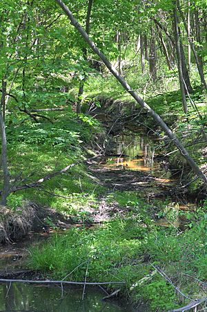
Nanticoke Creek looking downstream
|
|
| Physical characteristics | |
| Main source | valley on Penobscot Mountain in Hanover Township, Luzerne County, Pennsylvania between 1,000 and 1,020 feet (300 and 310 m) |
| River mouth | Susquehanna River in Hanover Township, Luzerne County, Pennsylvania 515 ft (157 m) 41°12′44″N 75°58′50″W / 41.2122°N 75.9805°W |
| Length | 4.4 mi (7.1 km) |
| Basin features | |
| Progression | Susquehanna River → Chesapeake Bay |
| Tributaries |
|
Nanticoke Creek is a small stream, or tributary, that flows into the Susquehanna River in Luzerne County, Pennsylvania. It is about 4.4 miles (7.1 km) long. The creek flows through Hanover Township and the city of Nanticoke.
The land around Nanticoke Creek, called its watershed, covers 7.57 square miles (19.6 km2). The creek has one main smaller stream joining it, called Espy Run. Nanticoke Creek faces challenges because of old mining activities. Water from abandoned mine drainage can make the creek's water too acidic or add metals to it. Despite these issues, efforts are being made to clean up the creek.
Contents
Journey of Nanticoke Creek
Nanticoke Creek starts its journey in a valley on Penobscot Mountain in Hanover Township. It flows west for a short distance. Then, it turns north-northwest, passing through a narrow area called Weller Gap.
After leaving the mountain, the creek flows north for a bit. It then turns west-northwest, briefly entering Nanticoke city before going back into Hanover Township. The creek continues north-northwest for almost a mile. It crosses major roads like Pennsylvania Route 29 and US Route 11. It also flows past the community of Loomis Park.
The creek then turns northwest and crosses the South Cross Valley Expressway again. After this, it flows northwest for a short distance. Here, Espy Run, its only named tributary, joins it from the left side. Nanticoke Creek then crosses the Sans Souci Parkway. It flows northwest one more time, crossing the South Cross Valley Expressway again. Finally, it reaches its end, joining the Susquehanna River.
Nanticoke Creek meets the Susquehanna River about 183.04 miles (294.57 km) before the Susquehanna reaches its own mouth.
Smaller Streams Joining Nanticoke Creek
Besides many unnamed small streams, Nanticoke Creek has one important named tributary: Espy Run. Espy Run flows into Nanticoke Creek about 0.42 miles (0.68 km) upstream from where Nanticoke Creek meets the Susquehanna River. The area that drains into Espy Run is 3.14 square miles (8.1 km2). There's also another stream in the area, sometimes called Leuders Creek, but it doesn't have an official name.
Water Quality of Nanticoke Creek
The Pennsylvania Department of Environmental Protection says that Nanticoke Creek's water quality isn't as good as it should be. This is mainly because of metals and the pH level (how acidic or basic the water is). The biggest reason for this pollution is water from old, abandoned mines.
Even though the creek is affected by old mining areas, the upper parts of the creek don't have much pollution. The creek can lose water into underground mines. It also gets polluted water from places like the Truesdale Mine Discharge and the Askam Borehole. These are spots where water from old mines flows into the creek.
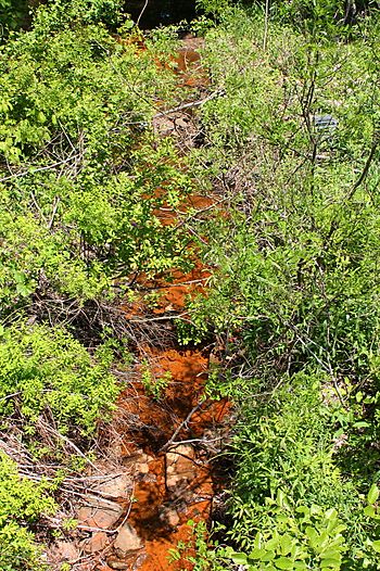
Sometimes, you might see orange sediment on the bottom of the creek. This orange color comes from a lot of iron in the water, which is common in areas with old mines. This orange material is sometimes called "yellow boy."
Land and Environment
The land around Nanticoke Creek is mostly covered by forests (about 67%). However, there are also areas with cities and towns (about 12%) and land affected by mining (about 10%). Some parts are grassland (8.6%) and wetlands (1.6%).
The Nanticoke Creek area is part of the Northern Anthracite Coal Field. This means that a lot of coal mining, both underground and on the surface, has happened here for over 100 years. This mining has changed the look of the land and how water flows. You can still see piles of mining waste and old mining pits.
Mountains like Little Wilkes-Barre Mountain and Penobscot Mountain are partly in the creek's watershed. The city of Nanticoke and other smaller communities like Loomis Park and Hanover are also in this area. There's even a reservoir called the Hanover Reservoir in the southwestern part of the watershed.
A large hole, called the Askam Borehole, was made in the early 1970s. It was created to help drain water from an underground mine pool and prevent flooding. Water from this borehole flows directly into Nanticoke Creek.
History and Name
Nanticoke Creek got its name from the Nanticoke tribe. This Native American group once had a village in the Wyoming Valley area before European settlers arrived.
Long ago, on some early maps, the creek was known as Muddy Run. But by 1776, it was already being called Nanticoke Creek. Over time, it was also mistakenly called by other names like Lee's Creek, Miller's Creek, and Warrior Run Creek.
In 1778, a forge (a place where metal is heated and shaped) was built on Nanticoke Creek. A gristmill (a mill for grinding grain) was also built that year. By 1793, there was both a sawmill and a gristmill on the creek.
Because of all the mining in the area, many projects have been started to clean up the creek. For example, in 2012, a project began to fix damage caused by the Askam Borehole. The United States Army Corps of Engineers also studied Nanticoke Creek in 2005 to help with restoration efforts.
Aquatic Life
Nanticoke Creek is officially recognized as a Coldwater Fishery and a Migratory Fishery. This means it's a place where cold-water fish could live and where fish might travel to lay their eggs.
However, in the 1970s, studies showed that the creek had almost no aquatic life (plants and animals that live in water). This was because the water quality was very poor due to pollution from the mines. Even so, experts believed the creek had the potential to support fish life if it could be cleaned up.
An artificial wetland called the Espy Run Wetland is located in the Nanticoke Creek watershed. Wetlands are important because they help filter water and provide homes for many plants and animals.
Images for kids
 | Roy Wilkins |
 | John Lewis |
 | Linda Carol Brown |


