Narayani Zone facts for kids
Quick facts for kids
Narayani
नारायणी अञ्चल
|
|
|---|---|
 |
|
| Country | |
| Time zone | UTC+5:45 (Nepal Time) |
Narayani (Nepali: नारायणी अञ्चल) was one of the fourteen zones of Nepal. It was located in the central southern part of the country. This zone was named after the Narayani River, which flows along its western border.
Contents
Geography and Nature
The Narayani zone covered different types of land in Nepal. These included the Terai (flat plains), the Inner Terai (valleys between hills), and the Hill regions. However, it did not include any high mountains or the Himalayan region.
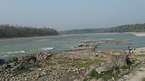
Narayani was known for its rich variety of plants and animals. The Narayani River and the Rapti River were the most important rivers in this zone. There were also a few lakes, such as Bisharari Lake and Garuda Lake.
Districts of Narayani
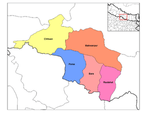
Narayani was divided into five smaller areas called districts. Each district had its own main town or "headquarters."
| District | Type of Land | Headquarters (Main Town) |
|---|---|---|
| Bara District | Outer Terai | Kalaiya |
| Chitwan District | Inner Terai | Bharatpur |
| Makwanpur District | Inner Terai | Hetauda |
| Parsa District | Outer Terai | Birganj |
| Rautahat District | Outer Terai | Gaur |
Economy and Industry
Narayani was an important area for businesses and factories in Nepal. It was the third largest industrial zone in the country. This means many goods were made and traded here.
Important Cities and Towns
Many important cities and towns were located in the Narayani zone. Some of these included Birganj, Parwanipur, Jitpur, Alau, Hetauda, Bharatpur, Narayanghat, Kalaiya, and Gaur.
Related Pages
See also
 In Spanish: Zona de Narayani para niños
 | Anna J. Cooper |
 | Mary McLeod Bethune |
 | Lillie Mae Bradford |


