
Naremburn, New South Wales facts for kids
Quick facts for kids NaremburnSydney, New South Wales |
|||||||||||||||
|---|---|---|---|---|---|---|---|---|---|---|---|---|---|---|---|

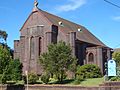
St Leonards Catholic Church, Naremburn
|
|||||||||||||||

Naremburn
Location in New South Wales
|
|||||||||||||||
| Population | 5,924 (2021 census) | ||||||||||||||
| • Density | 3,464/km2 (8,970/sq mi) | ||||||||||||||
| Established | 1853 | ||||||||||||||
| Postcode(s) | 2065 | ||||||||||||||
| Elevation | 74 m (243 ft) | ||||||||||||||
| Area | 1.71 km2 (0.7 sq mi) | ||||||||||||||
| Location | 6 km (4 mi) north of Sydney CBD | ||||||||||||||
| LGA(s) | City of Willoughby | ||||||||||||||
| State electorate(s) | Willoughby | ||||||||||||||
| Federal Division(s) | North Sydney | ||||||||||||||
|
|||||||||||||||

Naremburn is a cool suburb located on the lower North Shore of Sydney, New South Wales, Australia. It's about 6 kilometres north of the Sydney central business district, which is the main city area. Naremburn is part of the City of Willoughby local council.
Contents
History of Naremburn
The name Naremburn has been around since the 1800s. However, no one is quite sure where the name came from! It was first known as Central Township. The very first land grants in this area were given to Humphrey Evans and Peter Dargan way back in 1794.
There's a small cave in Flat Rock Gully near Naremburn. People used to believe that Henry Lawson, a famous Australian writer and poet, sometimes slept there. He was known for his stories about life in the Australian bush.
Naremburn even had its own Post Office. It opened on March 20, 1882, but it closed down in 1996.
People of Naremburn
In the 2021 Census, there were 5,924 people living in Naremburn. Most people, about 62%, were born in Australia. Many others came from countries like England, China, New Zealand, India, and Hong Kong.
English is the main language spoken at home by about 73% of people. But you'll also hear other languages like Mandarin, Cantonese, Japanese, Spanish, and Arabic. This shows that Naremburn is a very diverse place! When it comes to religion, many people said they had no religion. Others were Catholic, Anglican, or Buddhist.
Shopping and Local Spots
Naremburn has a small shopping area on Willoughby Road. It's a great place to find local shops and services. It's also just a short walk from Crows Nest, which has even more shops and cafes.
Churches in Naremburn
Naremburn is home to a couple of churches:
- St Leonards Catholic Church, which was built in 1913.
- St Cuthberts Anglican Church, also known as the Naremburn Cammeray Anglican Church.
Getting Around Naremburn
It's easy to get around Naremburn and to other parts of Sydney.
- Buses: Bus routes 114 and 115 travel through Naremburn. You can catch them along Willoughby Road to go to places like Balmoral, the Sydney city centre, or Chatswood.
- Trains: The closest train station is St Leonards railway station. It's on the Northern and North Shore & Western Lines of the Sydney Trains network. From here, you can travel to many different parts of Sydney.
- Freeway: The Warringah Freeway also runs through the suburb. This big road helps people drive quickly into the city.
Images for kids
-
St Cuthberts Anglican Church
-
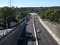
The Warringah Freeway
-
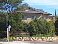
Willoughby Road, a main street in Naremburn


