
Willoughby, New South Wales facts for kids
Quick facts for kids WilloughbySydney, New South Wales |
|||||||||||||||
|---|---|---|---|---|---|---|---|---|---|---|---|---|---|---|---|

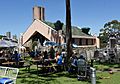
St Stephens Anglican Church
|
|||||||||||||||
| Population | 7,124 (2021 census) | ||||||||||||||
| • Density | 2,212/km2 (5,730/sq mi) | ||||||||||||||
| Established | 1850s | ||||||||||||||
| Postcode(s) | 2068 | ||||||||||||||
| Area | 3.22 km2 (1.2 sq mi) | ||||||||||||||
| Location | 8 km (5 mi) north of Sydney CBD | ||||||||||||||
| LGA(s) | City of Willoughby | ||||||||||||||
| State electorate(s) | Willoughby | ||||||||||||||
| Federal Division(s) | North Sydney | ||||||||||||||
|
|||||||||||||||
Willoughby is a cool suburb in Sydney, Australia. It's located on the lower North Shore, about 8 kilometers north of the main city center. The suburb is part of the local government area called the City of Willoughby.
Even though the city area is named after Willoughby, its main offices and big shopping areas are actually in the nearby suburb of Chatswood.
Contents
History of Willoughby
How Willoughby Got Its Name
People aren't completely sure how Willoughby got its name. Some historians think it was named after a church area. Others believe that a surveyor named Sir Thomas Mitchell named it to honor Sir James Willoughby Gordon. Mitchell had served under Gordon during a war, and Gordon was an important army leader in England when the First Fleet sailed to Australia.
Early European Settlement
Captain Arthur Phillip was looking for "good land, well watered." This search led to the discovery of the shores of Roseville Chase. Here, Samuel Bates built one of the first farms at a spot called Echo Point.
Later, more buildings appeared. The first post office was built in 1871. In the same year, a small sandstone building called Pommy Lodge was constructed. It was first used as a church. Another old home, Laurel Bank Cottage, was built in 1884. Today, this cottage is used by a group called the Masonic Lodge for events.
Around 1920, a special road called Telford Lane was built. It used a unique paving method created by Thomas Telford in England. This lane is one of the few places in Sydney where you can still see this old road-building technique.
In 1934, the Willoughby incinerator was built. It was designed by a famous architect named Walter Burley Griffin. This building was very well-designed and fit perfectly with its surroundings. Both Telford Lane and the incinerator are considered important historical sites.
For 64 years, Willoughby was home to the main offices of the Nine Network, a big TV channel. Their tall Channel 9 TV Tower was once the tallest in Australia, standing at 233 meters high! In 2020, the TV channel moved to North Sydney. The tower was taken down starting in 2021 to make way for new homes.
Historic Places to See
Willoughby has several places that are listed for their historical importance. These include:
- 85–87 Penshurst Street: Laurelbank
- 2 Small Street: Walter Burley Griffin Incinerator, Willoughby
Shopping and Food
Willoughby has many small shops, restaurants, and hotels. You can find groups of shops mainly along Mowbray Road, Willoughby Road, Penshurst Street, and High Street.
Parks and Fun Activities
Willoughby offers great places for outdoor fun and sports:
- Bicentennial Reserve: This large park includes Hallstrom Park. It has fields for soccer, T-ball, and softball, plus a playground for kids.
- Willoughby Leisure Centre: This center has a 25-meter swimming pool, spas, a kids' pool, and swimming lessons. It also has a gym, basketball courts, netball courts, and a baseball field.
- Flat Rock Gully: This is a bushland area built on an old rubbish tip. It has two walking tracks that follow a creek line down to Long Bay.
Other parks and sports spots include:
- Carlson Park
- Julian St Park
- Willoughby Squash courts
- Hallstrom Park
- Willoughby Park
Getting Around Willoughby
The closest train station for Willoughby residents is Artarmon, which is on the western edge of the suburb. Willoughby is also close to St Leonards and Chatswood stations. Many bus routes serve the area, making it easy to get around.
The Gore Hill Freeway runs along the southern border of Willoughby. This is a major road that helps people travel into the Sydney CBD.
Some bus routes in Willoughby include:
- 115: Chatswood to Pitt Street (via Crows Nest, North Sydney)
- 120: Chatswood to Queen Victoria Building (via Warringah Freeway)
- 205: Willoughby East to City Gresham Street (via Warringah Freeway)
- 267: Chatswood to Crows Nest (via Northbridge)
The Busways' Willoughby Bus Depot is also located in Willoughby East.
Schools in Willoughby
Willoughby has several schools for different age groups:
- Willoughby Public School (Kindergarten to Year 6)
- Willoughby Girls High School (Year 7 to Year 12, for girls only)
- St Thomas' Catholic Primary School (Kindergarten to Year 6, a Catholic school)
Other Local Spots
- Willoughby Fire Station, Laurel Street
- 1st Willoughby Scouts, Laurel Street
- Bridgeview Hotel, Willoughby Road
- The Willoughby Hotel, Penshurst Street
Churches in Willoughby
- Armenian Evangelical Church
- St Stephen's Anglican Church
- St Thomas's Catholic Church
- Willoughby Uniting Church
- Willoughby Presbyterian Church
Who Lives in Willoughby?
In 2021, there were 7,124 people living in Willoughby. Most people (62.1%) were born in Australia. Other common birthplaces included China (4.6%), England (4.4%), and Hong Kong (2.5%).
Most people (68.7%) speak only English at home. Other languages spoken include Mandarin (5.9%), Cantonese (4.6%), and Armenian (2.0%). When it comes to religion, many people said they had No Religion (39.8%), followed by Catholic (25.5%) and Anglican (11.4%).
Willoughby is known for having a large Armenian community. Many Armenian families moved to the area in the 1960s and 1970s, especially after an Armenian Apostolic Church was built nearby in Chatswood. Willoughby has several Armenian churches and community centers. It's also home to the first Armenian Saturday School, which still teaches Armenian language and culture at Willoughby Girls High School.
Famous People From Willoughby
Some well-known people have lived in Willoughby:
- John Davies: An Olympic swimmer who won a gold medal for Australia in 1952.
- Matthew Reilly: A very popular author who writes best-selling books.
- Evonne Goolagong: A legendary tennis player.
- Doc Neeson: The lead singer of the famous Australian band, The Angels.
Images for kids
-
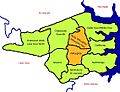
Map of Willoughby
-
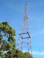
The old TCN-9 TV tower
-
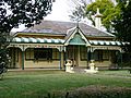
Laurel Bank Cottage (built in 1884)
-
The incinerator designed by Walter Burley Griffin (built in 1934)
-
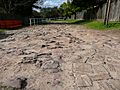
Telford Lane (built around 1920)
-
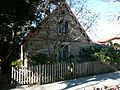
Pommy Lodge (built in 1871)


Griffin_incinerator_Willoughby_089.jpg)


