Cammeray facts for kids
Quick facts for kids CammeraySydney, New South Wales |
|||||||||||||||
|---|---|---|---|---|---|---|---|---|---|---|---|---|---|---|---|
| Population | 7,006 (2016 census) | ||||||||||||||
| • Density | 4,670/km2 (12,100/sq mi) | ||||||||||||||
| Postcode(s) | 2062 | ||||||||||||||
| Elevation | 87 m (285 ft) | ||||||||||||||
| Area | 1.5 km2 (0.6 sq mi) | ||||||||||||||
| Location | 5 km (3 mi) north of Sydney CBD | ||||||||||||||
| LGA(s) | North Sydney Council | ||||||||||||||
| State electorate(s) | Willoughby | ||||||||||||||
| Federal Division(s) | North Sydney | ||||||||||||||
|
|||||||||||||||
Cammeray is a suburb located just five kilometres north of the Sydney Central Business District (CBD). It's part of the North Sydney Council area. Cammeray is found in the Lower North Shore part of Northern Sydney.
Contents
History of Cammeray
First People: Aboriginal Culture
Cammeray gets its name from the Cammeraygal people. This Aboriginal clan used to live all over the Lower North Shore area. Scientists have found proof that Indigenous people lived here at least 5,800 years ago. They found old shell piles (called middens) at Folly Point. There are also cave paintings in Primrose Park.
European Settlement and Growth
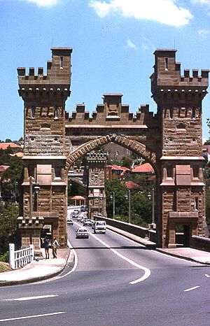
Before the 1920s, Cammeray was known as Suspension Bridge. This was because of the Long Gully Bridge that connected Northbridge to Cammeray. The area grew slowly at first. This was mainly because of its steep hills and being far from transport.
Even with a land boom in the 1880s, most building was in the south. Some boatmen's houses were built on Folly Point. The rest of the area was mostly bushland, farms, and gardens. Cammeray was also home to Sydney's first quarry. Sandstone from here was used to build many early Sydney buildings.
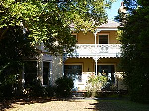
Joseph Palmer Abbott, a politician, built a large house called Tarella around 1886. It was an Italianate style mansion on Amherst Street. Palmer Street in Cammeray is named after him. Tarella has a coachhouse with a cool clock tower. It is now a heritage-listed building.
In 1892, a suspension bridge was built. A company built it to encourage people to buy new homes. In 1914, the first tram crossed the bridge. This made it easier to get from the new suburb to North Sydney. More land was sold after 1909 when a tramway was built. By the 1940s, cars made the area even more reachable. Many houses were built along the waterfront.
Changes and Development
In the 1960s, a big road called the Warringah Expressway was built. It cut through parts of North Sydney, including Cammeray. Some houses and parts of parks were taken for the road. The expressway also divides Cammeray. You can only cross it at West, Miller, Ernest, and Falcon Streets.
Amherst Street is named after William Pitt Amherst. He was a Governor-General of India a long time ago. Other important buildings include Tarella and the Cammeray Substation.
Who Lives in Cammeray?
According to the 2016 census, 7,006 people lived in Cammeray. Most people (63.6%) were born in Australia. Other common birthplaces included England (6.6%) and New Zealand (2.8%). Most people (78.6%) spoke only English at home. The next most common language was Mandarin (1.7%).
Shops and Businesses
Miller Street is the main shopping street in Cammeray. You can find restaurants, cafes, the post office, and other small shops there. Cammeray Square is a modern shopping and living complex on Miller Street. Near Green Park, there's another small area with businesses. This gives the local area a friendly, village feel.
Getting Around
Cammeray is close to the Sydney CBD and the Warringah Expressway. This makes it easy to travel in all directions. You can use public buses to get around. Buses go to the Sydney CBD, North Sydney, Milsons Point, and Crows Nest.
Schools in Cammeray
Cammeray has two public primary schools. They teach students from Kindergarten to Year 6.
- Cammeray Public School is in the northern part of the suburb.
- Anzac Park Public School opened in 2016 and is more to the south.
Churches
All Saints' Anglican Church on Carter Street is the only church in Cammeray. It is part of the Naremburn Cammeray Anglican Church.
Homes in Cammeray
Cammeray has a mix of different types of homes. In 2016, about 75.8% of homes were apartments or units.
- 23.3% were separate houses.
- 35.5% were medium-density homes (like townhouses).
- 40.2% were high-density homes (like large apartment buildings).
Parks and Fun Things to Do
Cammeray has many sports facilities and open spaces. The nearby bushland and Middle Harbour are great for bushwalking and boating.
- St Thomas Rest Park is a cemetery park on West Street. It's a quiet place to visit.
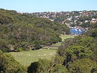
- Tunks Park is a large area for sports and fun. It's surrounded by bushland and Middle Harbour. It has open spaces, walking tracks, a playground, and picnic areas. There are three sports fields used for cricket, soccer, and rugby. It's a popular spot for exercise and dog walking. Bushwalking tracks lead to Naremburn and Northbridge. There's also a small boat ramp for boats to enter Middle Harbour.
- Cammeray Park is a big green space in the southern part of Cammeray. It has a special turf field for soccer and rugby. Around it, you'll find private tennis courts, a skate park, and a cricket field. It also has the Cammeray Golf Club, which is a 9-hole public course.
- Green Park is an open grass area used for relaxing and dog walking. It also has two public tennis courts and a child care centre.
- Anzac Park is a smaller open space. It's mainly used for picnics and dog walking. It has a large community garden. In the western part, there's a grove of trees with plaques. These plaques honour Australian service members from World War II.
You can also find several cycling paths in Cammeray. These paths connect to Chatswood and to the Sydney CBD via the Harbour Bridge.
Famous People from Cammeray
- Ben Fordham - a news reporter
- Jodie Speers - a journalist
- April Pengilly - an actress and model
 | Audre Lorde |
 | John Berry Meachum |
 | Ferdinand Lee Barnett |


