Nathrop, Colorado facts for kids
Quick facts for kids
Nathrop, Colorado
|
|
|---|---|

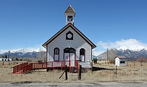
An old school in Nathrop.
|
|
| Country | |
| State | |
| County | Chaffee County |
| Government | |
| • Type | unincorporated town |
| Area | |
| • Total | 1.873 km2 (0.723 sq mi) |
| • Land | 1.873 km2 (0.723 sq mi) |
| • Water | 0.000 km2 (0 sq mi) |
| Elevation | 2,343 m (7,687 ft) |
| Population
(2020)
|
|
| • Total | 288 |
| • Density | 153.76/km2 (398.2/sq mi) |
| Time zone | UTC-7 (MST) |
| • Summer (DST) | UTC-6 (MDT) |
| ZIP Code |
81236
|
| Area code(s) | 719 |
| GNIS feature ID | 2805910 |
Nathrop is a small community in Colorado, United States. It's located in Chaffee County. Even though it's not a big city with its own local government, it has a post office and is recognized as a "census-designated place" (CDP). This means the U.S. Census Bureau counts its population separately. In 2020, about 288 people lived there. Nathrop is known for its beautiful mountain scenery and interesting geological features.
Contents
A Look Back at Nathrop's Past
Nathrop got its name from Charles Nachtrieb, who owned the land where the town was built. Back in 1880, a railroad called the Denver and Rio Grande Railroad built tracks right through Nathrop. These tracks were part of an important route called the Tennessee Pass line.
The railroad tracks were used for many years but were stopped in 1997. However, the company that owns the line now, Union Pacific, might decide to open them again in the future.
Exploring Nathrop's Geography
Nathrop is a small area, covering about 1.873 square kilometers (or 463 acres) of land. It's surrounded by the natural beauty of Colorado.
Ruby Mountain: A Gemstone Discovery
Just about a mile northeast of Nathrop, you'll find a special place called Ruby Mountain. It's a large rock formation made of rhyolite. Rhyolite is a type of volcanic rock, similar to granite but formed from lava that cooled quickly.
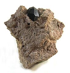
Inside this rock, you can find small, beautiful crystals called spessartite garnet. Garnets are popular gemstones. You might also discover small, shiny black pebbles at the bottom of the cliffs. These are called "Apache tears" by collectors and are a type of obsidian, which is natural volcanic glass.
Who Lives in Nathrop?
The United States Census Bureau keeps track of how many people live in places like Nathrop. They officially defined Nathrop as a "census-designated place" for the United States Census 2020. This helps them count everyone living there.
| Nathrop CDP, Colorado | ||
|---|---|---|
| Year | Pop. | ±% |
| 2020 | 288 | — |
| Source: United States Census Bureau | ||
Fun Places to Visit Near Nathrop
Nathrop is close to many exciting outdoor attractions where you can explore nature and history:
- Alpine Tunnel
- Arkansas Headwaters Recreation Area
- Browns Canyon National Monument
- Mount Princeton
- San Isabel National Forest
- St. Elmo
 | Shirley Ann Jackson |
 | Garett Morgan |
 | J. Ernest Wilkins Jr. |
 | Elijah McCoy |


