
National Register of Historic Places listings in Bannock County, Idaho facts for kids

Have you ever wondered about the old buildings and special places in your town or county? Many of these places are super important because of their history or unique design. In Bannock County, Idaho, there's a special list of these important spots called the National Register of Historic Places.
This list helps protect buildings, sites, and objects that are significant to American history, architecture, archaeology, engineering, or culture. It's like giving them a special badge of honor! When a place is on this list, it means it's recognized nationally for its value. In Bannock County, there are 30 places on this list, and one of them is even a National Historic Landmark, which is an even higher level of importance!
Contents
Exploring Historic Places in Bannock County
Bannock County is home to many fascinating historic sites, from old forts to beautiful churches and unique homes. Let's take a closer look at some of these special places.
Fort Hall: A Landmark of History
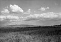
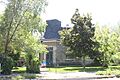
One of the most important sites in Bannock County is Fort Hall. This isn't just any old fort; it's a National Historic Landmark! Built way back in 1834, Fort Hall was a very important trading post and stopping point for pioneers traveling on the Oregon Trail and California Trail. Imagine all the people who passed through here, heading west for new lives! The original fort was used until 1856. Today, it reminds us of the brave people who explored and settled the American West.
Historic Buildings in Pocatello
Pocatello, Idaho has many buildings on the National Register. These places tell stories about how the city grew and changed over time.
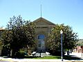
Pocatello Carnegie Library
The Pocatello Carnegie Library is a beautiful building that was added to the list in 1973. Libraries are super important for learning and community, and this one has been a center for knowledge in Pocatello for many years. It's located at 113 S. Garfield Avenue.
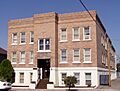
Pocatello Federal Building
Another significant building is the Pocatello Federal Building, listed in 1977. This building, found at Arthur Avenue and Lewis Street, has served as a center for government services in the area.
Churches with Rich History
Several churches in Pocatello are also recognized for their historical and architectural importance:
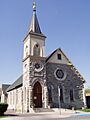
- The Church of the Assumption (listed 1979) at 528 N. 5th Avenue.
- St. Joseph's Catholic Church (listed 1978) at 455 N. Hayes.
- Trinity Episcopal Church (listed 1978) at 248 N. Arthur Street.
These churches are not just places of worship but also beautiful examples of architecture from different times.
Unique Homes and Apartments
Many historic homes and apartment buildings in Pocatello show us how people lived in the past.
- The John Hood House (listed 1978) at 554 S. 7th Avenue.
- The William A. Hyde House (listed 1983) at 429 N. 7th Street.
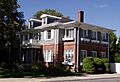
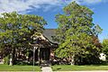
- The Standrod House (listed 1973) at 648 N. Garfield Avenue, built in 1902 for Judge D.W. Standrod.
- The Quinn Apartments (listed 1985) at 580 W. Clark Street.
- The Woolley Apartments (listed 1985) at 303 N. Hayes Avenue.
These buildings often have special architectural styles that were popular when they were built.
Idaho State University Administration Building
The Idaho State University Administration Building, located at 919 S. 8th Street on the university campus, was added to the list in 1993. This building is a key part of Idaho State University's history and development.
Historic Places in Other Bannock County Towns
It's not just Pocatello that has historic treasures! Other towns in Bannock County also have places on the National Register.
McCammon's Historic Buildings
In McCammon, Idaho, you can find:
- The H.O. Harkness Stable Building (listed 1980) at 105 S. Railroad Avenue.
- The McCammon State Bank Building (listed 1979) at 206 Center Street. This building was constructed in 1906 and is now known as the Harkness Hotel.
Lava Hot Springs' Historic Spots
Lava Hot Springs, Idaho, famous for its natural hot springs, also has some historic buildings:
- The L.D.S. Ward Building (listed 1999) at 187 S. 2nd Avenue.
- The Lava High School Gymnasium (listed 1997) at 202 W. Fife Street.
- The Riverside Inn (listed 1979) at 255 E. Portneuf Street.
- The Whitestone Hotel (listed 1980) at 2nd Avenue and Main Street, though this building was sadly taken down in 1997.
Historic Districts: Whole Neighborhoods with History
Sometimes, it's not just one building that's historic, but a whole group of buildings or a neighborhood! These are called Historic Districts.
- The East Side Downtown Historic District in Pocatello (listed 1994) includes parts of E. Center Street and N. and S. 2nd Avenue.
- The Idaho State University Neighborhood Historic District in Pocatello (listed 1984) is roughly around 6th, 9th, Carter, and Center Streets.
- The Lincoln-Johnson Avenues Residential Historic District in Pocatello (listed 2006) is near W. Hayden Street, the Portneuf River, W. Benton Street, and the West Bench.
- The Old Town Residential Historic District in Pocatello (listed 2008) is roughly bounded by W. Benton, S. Garfield, and W. Lewis Streets, and the Portneuf River.
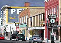
- The Pocatello Historic District (listed 1982) is roughly bounded by railroad tracks and W. Fremont, W. Bonneville, and Garfield Streets.
- The Pocatello Warehouse Historic District (listed 1996) is near S. 2nd Avenue, E. Halliday, E. Sutter, and the Oregon Short Line railroad tracks.
- The Pocatello Westside Residential Historic District (listed 2003) is roughly bounded by N. Arthur Avenue, W. Fremont Street, N. Grant Avenue, and W. Young Street.
These districts show how different parts of Pocatello developed over time, from busy downtown areas to quiet residential neighborhoods.
Images for kids
-

The A.F.R. Building in Pocatello.
-
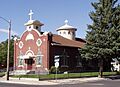
The Church of the Assumption in Pocatello.
-
A marker for the historic Fort Hall site.
-
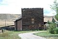
The H.O. Harkness Stable Building in McCammon.
-
The John Hood House in Pocatello.
-

The William A. Hyde House in Pocatello.
-

The Idaho State University Administration Building.
-

The McCammon State Bank Building, now the Harkness Hotel.
-
The Pocatello Carnegie Library.
-

The Pocatello Federal Building.
-
A view of Downtown Pocatello Historic District.
-
The Quinn Apartments in Pocatello.
-
The Rice-Packard House in Pocatello.
-
St. Joseph's Catholic Church in Pocatello.
-

The Standrod House in Pocatello.
-
The Sullivan-Kinney House in Pocatello.
-

Trinity Episcopal Church in Pocatello.
-

The Woolley Apartments in Pocatello.


