
National Register of Historic Places listings in Barton County, Kansas facts for kids

Have you ever wondered what makes a building or a place special enough to be protected for the future? In Barton County, Kansas, there are many amazing places that are part of something called the National Register of Historic Places. This is a special list of buildings, sites, and objects across the United States that are important to history, architecture, archaeology, engineering, or culture.
When a place is added to this list, it means it's recognized as a valuable part of our past. It helps people learn about history and makes sure these places are taken care of for generations to come. In Barton County, there are 19 places currently on this list. A few others were once listed but have since been removed.
Contents
What is the National Register of Historic Places?
The National Register of Historic Places is like a hall of fame for important historical sites in America. It's managed by the National Park Service. When a place gets on this list, it means it has a unique story to tell about our country's past. This could be a building where something important happened, a special bridge, or even a natural landmark that played a role in history.
Being on the list helps protect these places. It encourages people to preserve them and sometimes even helps them get special funding for repairs or upkeep. It's all about making sure we don't forget the amazing history all around us!
Historic Places in Barton County
Barton County is home to many interesting sites that tell stories about its past. From old homes to unique bridges and even a famous rock, these places show us what life was like long ago.
Homes and Buildings with History
Some of the places on the list are old homes and public buildings. They show us how people lived and worked in the past.
Abel House
The Abel House in Great Bend was added to the list in 2001. It's an example of the beautiful homes built in the area.
Nagel House
Also in Great Bend, the Nagel House was listed in 2001. These homes often have special architectural styles that were popular when they were built.
Crest Theater
The Crest Theater in Great Bend, listed in 2005, is a historic movie theater. Imagine watching a film there decades ago! Theaters like this were once the heart of entertainment in many towns.
Hoisington High School
The old Hoisington High School building in Hoisington became a historic place in 2005. Many students learned and grew up within its walls.
Manweiler-Maupin Chevrolet
This building in Hoisington, listed in 2012, was once a Chevrolet dealership. It's part of a group of historic sites related to roadside businesses and travel in Kansas.
US Post Office-Hoisington
The US Post Office-Hoisington building, listed in 1989, served as a vital communication hub for the community for many years.
Wolf Hotel
The Wolf Hotel in Ellinwood, listed in 2002, is a historic hotel. Hotels were important places for travelers and community gatherings in the past.
Wolf Park Band Shell
Also in Ellinwood, the Wolf Park Band Shell was added in 2003. A band shell is an outdoor stage where concerts and performances are held. Imagine people gathering in the park to listen to music here!
Historic Bridges and Crossings
Bridges are not just ways to get across water; some are important historical structures. Several bridges in Barton County are on the list.
Beaver Creek Native Stone Bridge
This bridge near Beaver, listed in 2008, is special because it's made of native stone. It shows the building methods used a long time ago.
Other Historic Bridges near Beaver
Several other bridges near Beaver, including Bridge No. 218, Bridge No. 222, Bridge No. 640, and Bridge No. 650, were also listed in 2008. These bridges are important examples of early engineering in the area.
Walnut Creek Bridge
The Walnut Creek Bridge near Heizer, listed in 1990, is another example of a historic bridge that helped people travel across the land.
Walnut Creek Crossing
The Walnut Creek Crossing near Great Bend Township, listed in 1972, is a historic spot where people used to cross Walnut Creek. These crossings were important for early settlers and travelers.
Military and Natural Landmarks
Barton County also has historic sites related to military history and natural landmarks.
Great Bend Army Air Field Hanger
The Great Bend Army Air Field Hanger in Great Bend, listed in 2015, was part of an important military airfield. Airfields like this played a big role during wartime.
Norden Bombsight Storage Vaults
Also at the former Great Bend Army Air Field, the Norden Bombsight Storage Vaults were listed in 2015. These vaults were used to store important military equipment.
Pawnee Rock
Pawnee Rock is a famous natural landmark in Pawnee Rock. It was listed way back in 1970! This large rock formation was an important landmark for Native Americans and early pioneers traveling the Santa Fe Trail. It offered a great view and was a well-known stopping point.
Places Formerly on the List
Sometimes, a place that was once on the National Register of Historic Places might be removed. This can happen if the building is changed too much, or if it is no longer there. In Barton County, two bridges were removed from the list in 2015.
Hitschmann Cattle Underpass Bridge
This bridge near Hitschmann was listed in 2008 but later removed.
Hitschmann Double Arch Bridge
Also near Hitschmann, this bridge was listed in 2008 and then removed in 2015.
These former listings remind us that even historic places can change over time.
Images for kids
-
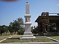
Pawnee Rock, a historic landmark in Barton County.

