
National Register of Historic Places listings in Callaway County, Missouri facts for kids

Have you ever wondered about the oldest and most important buildings or places in your state? In Callaway County, Missouri, there's a special list of these historic spots! It's called the National Register of Historic Places. This list includes buildings, areas, and even ancient sites that are important to the history of the United States.
When a place is on this list, it means it's recognized for its history, architecture, or what happened there. Callaway County has 20 places on this list. Two of them are even more special and are called National Historic Landmarks. These landmarks are considered nationally important. Let's explore some of these amazing places!
Discovering Callaway County's History
Callaway County is full of interesting places that tell stories from the past. From old homes to battlefields and even ancient caves, these sites help us understand what life was like long ago.
Homes with History
Many of the places on the National Register are historic homes. These houses show us how people lived and built things in different times.
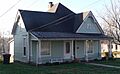
M. Fred Bell Cottages
In Fulton, Missouri, you can find two charming homes known as the M. Fred Bell Rental Cottage and the M. Fred Bell Speculative Cottage. They are located on East Fifth Street and were added to the list in the mid-1990s. These cottages are great examples of older homes in the area.
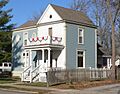
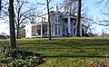
Brandon-Bell-Collier House
Also in Fulton, the Brandon-Bell-Collier House on West Ninth Street is another historic home. It was listed in 1998 and has a unique story to tell through its architecture.
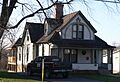
John Augustus Hockaday House
The John Augustus Hockaday House on Hockaday Avenue in Fulton was added to the list in 1980. It's a beautiful example of historic residential architecture.
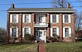
Robnett-Payne House
The Robnett-Payne House on East Fifth Street in Fulton is another important historic home. It joined the National Register in 1998.
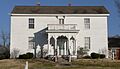
Dr. George M. Willing House
The Dr. George M. Willing House on Jefferson Street in Fulton was listed in 1980. It's a significant part of Fulton's historic neighborhood.
Important Buildings and Districts
Beyond individual homes, some larger areas or public buildings in Callaway County are also recognized for their historical value.
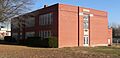
George Washington Carver School
The George Washington Carver School in Fulton, located on Westminister, is a very important site. It was added to the list in 1996. This school played a big role in the community's history.
Court Street Historic Residential District
The Court Street Historic Residential District in Fulton covers an area roughly along Court Street. This district was recognized in 2007 because it has many historic homes and buildings that show how the city grew over time.
Downtown Fulton Historic District
The heart of Fulton, the Downtown Fulton Historic District, is also on the list. This area, bounded by Fourth Street, Market, Seventh Street, and Jefferson Avenue, was listed in 2004. It's where many historic businesses and public buildings are located.
Oakley Chapel African Methodist Episcopal Church
Near Tebbetts, Missouri, the Oakley Chapel African Methodist Episcopal Church is a historic church building. It was added to the National Register in 2008 and is an important part of the local community's heritage.
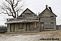
Pitcher Store
The Pitcher Store on Pitcher Road in Fulton was listed in 2001. Old stores like this one are important because they show us how people shopped and traded goods in the past.
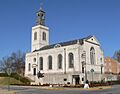
Richland Christian Church
The Richland Christian Church near Kingdom City, Missouri, on Callaway County Road 220, was added to the list in 2001. It's another example of a historic community gathering place.
White Cloud Presbyterian Church and Cemetery
The White Cloud Presbyterian Church and Cemetery is located on Missouri Route F near Fulton. This site, listed in 2010, includes both a historic church and its cemetery, telling stories of past generations.
Sites of National Importance
Two places in Callaway County are so important that they are recognized as National Historic Landmarks. This is a very high honor!
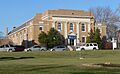
Westminster College Gymnasium
The Westminster College Gymnasium in Fulton is a famous landmark. It was listed in 1968. This gym is known because Winston Churchill, a famous British leader, gave his "Iron Curtain" speech here in 1946. This speech was a very important moment in world history.
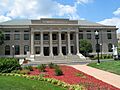
Westminster College Historic District
The larger Westminster College Historic District in Fulton, including the campus area, was added to the National Register in 1982. This district includes many historic buildings that make up the college campus.
Winston Churchill Memorial
Also in Fulton, the Winston Churchill Memorial at Seventh Street and Westminster Avenue was listed in 1972. This memorial honors Winston Churchill and his famous speech given at Westminster College.
Ancient Discoveries and Battlefields
Callaway County also holds secrets from much older times and important moments from wars.
Cote Sans Dessein Archeological Site
The Cote Sans Dessein Archeological Site near Tebbetts, Missouri, is a very old site. It was listed in 1971. Archeological sites like this help scientists learn about ancient people who lived in the area thousands of years ago.
Mealy Mounds Archeological Site
Another ancient site is the Mealy Mounds Archeological Site near Mokane, Missouri. Listed in 1971, this site contains mounds built by early Native American cultures.
Research Cave
The Research Cave near Portland, Missouri, is a National Historic Landmark, listed in 1966. This cave is incredibly important for understanding ancient life and environments in Missouri. Scientists have found many clues about the past here.
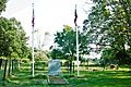
Moore's Mill Battlefield
The Moore's Mill Battlefield is located along Auxvasse Creek near Calwood, Missouri. This site was added to the list in 2015. It's where the Battle of Moore's Mill took place during the American Civil War. This battle was an important event in Missouri's history.
Images for kids
-
M. Fred Bell Rental Cottage
-
M. Fred Bell Speculative Cottage
-
Brandon-Bell-Collier House
-
George Washington Carver School
-
John Augustus Hockaday House
-
Moore's Mill Battlefield
-
Pitcher Store
-
Robnett-Payne House
-
Westminster College Gymnasium
-
Westminster College Historic District
-
Dr. George M. Willing House
-
Winston Churchill Memorial


_from_SW_2.JPG)
_from_NE_1.JPG)


_from_S_2.JPG)


_from_E_1.JPG)

