
National Register of Historic Places listings in Carter County, Missouri facts for kids

This page lists special places in Carter County, Missouri that are part of the National Register of Historic Places. Think of it like a national scrapbook of important buildings, areas, and sites that tell us about America's past. These places are protected because they are historically or architecturally important.
There are 30 different properties and districts in Carter County that are on this list. You can even see where many of them are on a map using their special location coordinates!
Historic Places in Carter County
| Name on the Register | Image | Date listed | Location | City or town | Description | |
|---|---|---|---|---|---|---|
| 1 | Mrs. Louis Bedell House |
(#80002324) |
3rd and Maple Sts. 36°49′55″N 90°49′15″W / 36.831944°N 90.820833°W |
Grandin | ||
| 2 | Big Spring Historic District |
 |
(#81000101) |
E of Van Buren on MO 103 36°56′55″N 90°59′35″W / 36.948611°N 90.993056°W |
Van Buren | |
| 3 | Earl Boyer House |
(#80002325) |
5th St. 36°49′42″N 90°49′18″W / 36.828333°N 90.821667°W |
Grandin | ||
| 4 | Chubb Hollow Site |
(#89002272) |
Address Restricted |
Van Buren | ||
| 5 | J. W. Gibson House |
(#80002326) |
6th and Pine Sts. 36°49′51″N 90°49′45″W / 36.830833°N 90.829167°W |
Grandin | ||
| 6 | Gooseneck Site |
(#90001473) |
Hawes Memorial Campground: E½ SE¼ SW¼ of Section 15, Township 25 North, Range 1 East 36°49′20″N 90°56′48″W / 36.822222°N 90.946667°W |
Poplar Bluff | ||
| 7 | Delia Greensfelder House |
(#80002327) |
4th and N. Cherry Sts. 36°49′48″N 90°49′21″W / 36.83°N 90.8225°W |
Grandin | ||
| 8 | Loretta Herrington House |
(#80002328) |
5th St. 36°49′44″N 90°49′21″W / 36.828889°N 90.8225°W |
Grandin | ||
| 9 | James Hinton House |
(#80002329) |
Walnut St. 36°50′00″N 90°49′11″W / 36.833333°N 90.819722°W |
Grandin | ||
| 10 | Nettie Jacobson House |
(#80002330) |
6th and Oak Sts. 36°49′49″N 90°49′38″W / 36.830278°N 90.827222°W |
Grandin | ||
| 11 | Isaac Kelley Site (23CT111 and 23CT1) |
(#87002531) |
Address Restricted |
Hunter | ||
| 12 | Nola Kitterman House |
(#80002331) |
6th St. 36°49′54″N 90°49′53″W / 36.831667°N 90.831389°W |
Grandin | ||
| 13 | Wallace Knapp House |
(#80002332) |
6th and S. Elm Sts. 36°49′49″N 90°49′37″W / 36.830278°N 90.826944°W |
Grandin | ||
| 14 | Buford Lawhorn House |
(#80002333) |
6th St. 36°49′52″N 90°49′44″W / 36.831111°N 90.828889°W |
Grandin | ||
| 15 | Iva Lewis House |
(#80002334) |
6th St. 36°49′49″N 90°49′41″W / 36.830278°N 90.828056°W |
Grandin | ||
| 16 | Masonic Lodge |
(#80002335) |
5th and S. Elm Sts. 36°49′49″N 90°49′33″W / 36.830278°N 90.825833°W |
Grandin | ||
| 17 | Terry Mays House |
(#80002336) |
6th and S. Plum St. 36°49′44″N 90°49′26″W / 36.828889°N 90.823889°W |
Grandin | ||
| 18 | Thornton McNew House |
(#80002337) |
6th and Spruce Sts. 36°49′53″N 90°49′47″W / 36.831389°N 90.829722°W |
Grandin | ||
| 19 | Mill Pond |
(#80002338) |
Off MO 21 36°49′53″N 90°48′46″W / 36.831389°N 90.812778°W |
Grandin | ||
| 20 | Della Nance House |
(#80002339) |
6th St. 36°49′50″N 90°49′41″W / 36.830556°N 90.828056°W |
Grandin | ||
| 21 | Hazel Owens House |
(#80002340) |
5th St. 36°49′52″N 90°49′39″W / 36.831111°N 90.8275°W |
Grandin | ||
| 22 | Phillips Bay Mill (23CT235) |
(#87002536) |
Along a small Current River tributary southeast of Eastwood 36°51′02″N 90°57′45″W / 36.850556°N 90.962500°W |
Eastwood | ||
| 23 | Ernie Phillips House |
(#80002341) |
3rd and N. Cherry Sts. 36°49′53″N 90°49′20″W / 36.831389°N 90.822222°W |
Grandin | ||
| 24 | Alvis Powers House |
(#80002342) |
Walnut St. 36°49′56″N 90°49′13″W / 36.832222°N 90.820278°W |
Grandin | ||
| 25 | Hazel Shoat House |
(#80002343) |
5th St. 36°49′51″N 90°49′37″W / 36.830833°N 90.826944°W |
Grandin | ||
| 26 | Sixth Street Historic District |
(#80002344) |
6th St. 36°49′46″N 90°49′36″W / 36.829444°N 90.826667°W |
Grandin | ||
| 27 | James Smith House |
(#80002345) |
6th St. 36°49′43″N 90°49′24″W / 36.828611°N 90.823333°W |
Grandin | ||
| 28 | Lawrence Smith House |
(#80002346) |
3rd St. 36°49′54″N 90°49′10″W / 36.831667°N 90.819444°W |
Grandin | ||
| 29 | William F. Smith House |
(#80002347) |
6th St. 36°49′43″N 90°49′31″W / 36.828611°N 90.825278°W |
Grandin | ||
| 30 | Lee Tucker House |
(#80002348) |
3rd St. 36°49′56″N 90°49′30″W / 36.832222°N 90.825°W |
Grandin |
Images for kids
-
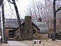
Big Spring Lodge, part of the Big Spring Historic District.

All content from Kiddle encyclopedia articles (including the article images and facts) can be freely used under Attribution-ShareAlike license, unless stated otherwise. Cite this article:
National Register of Historic Places listings in Carter County, Missouri Facts for Kids. Kiddle Encyclopedia.