
National Register of Historic Places listings in Chesterfield County, South Carolina facts for kids

Have you ever wondered about old buildings and places that are super important to history? In the United States, there's a special list called the National Register of Historic Places. It's like a hall of fame for buildings, sites, and objects that tell us a lot about the past. When a place is on this list, it means it's recognized for its historical, architectural, or archaeological importance.
This article is all about the cool historic places in Chesterfield County, South Carolina, that are on this special list. There are 9 of these amazing spots in the county! These places help us understand the history of Chesterfield County and the whole state of South Carolina.
Contents
- What is the National Register of Historic Places?
- Historic Places in Chesterfield County
- Cheraw Historic District
- East Main Street Historic District (Chesterfield)
- Evy Kirkley Site
- Dr. Thomas E. Lucas House
- St. David's Episcopal Church and Cemetery
- Seaboard Air Line Railway Depot in McBee
- Seaboard Air Line Railway Depot in Patrick
- Robert Smalls School
- West Main Street Historic District (Chesterfield)
- Images for kids
What is the National Register of Historic Places?
The National Register of Historic Places is the official list of the nation's historic places worth saving. It's managed by the National Park Service. Being on the list helps protect these places and often makes them eligible for special grants or tax benefits to help keep them in good shape. It's a way to make sure future generations can also learn from and enjoy these important parts of our history.
Historic Places in Chesterfield County
Chesterfield County is home to several places that have earned a spot on the National Register. These sites include old churches, homes, train stations, and even entire neighborhoods! Each one has a unique story to tell about the people and events that shaped this area.
Cheraw Historic District
The Cheraw Historic District is a large area in the town of Cheraw, South Carolina. It includes many historic buildings that show what the town looked like long ago. This district was added to the list on November 20, 1974. Walking through this area is like taking a step back in time, with beautiful old homes and public buildings.
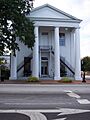
East Main Street Historic District (Chesterfield)
In the town of Chesterfield, South Carolina, the East Main Street Historic District is another important area. It includes buildings along Hursey Drive and East Main and Craig Streets. This district was recognized on May 4, 1982, for its collection of historic buildings that tell the story of Chesterfield's growth.
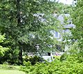
Evy Kirkley Site
The Evy Kirkley Site is located near McBee, South Carolina. This site is a bit of a mystery because its exact location is kept secret to protect it. It was added to the National Register on August 3, 1979. Sites like this are often archaeological, meaning they might contain clues about ancient cultures or early settlements.
Dr. Thomas E. Lucas House
The Dr. Thomas E. Lucas House is a historic home at 716 West Main Street in Chesterfield, South Carolina. This house was added to the list on May 4, 1982, the same day as the East Main Street Historic District. It's a great example of the architecture from its time.
St. David's Episcopal Church and Cemetery
St. David's Episcopal Church and Cemetery is a very old and important site in Cheraw, South Carolina. It's located on Church Street and was listed on September 22, 1971. This church and its cemetery have seen many historical events and are a key part of Cheraw's heritage.
Seaboard Air Line Railway Depot in McBee
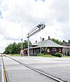
The Seaboard Air Line Railway Depot in McBee is an old train station in McBee, South Carolina. It's found on West Pine Avenue. This depot was added to the National Register on September 2, 1999. Train stations were once very busy places, connecting towns and helping people and goods travel across the country.
Seaboard Air Line Railway Depot in Patrick
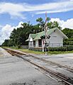
Another historic train station is the Seaboard Air Line Railway Depot in Patrick, located in Patrick, South Carolina. It's on Winburn Street and was listed on February 22, 1999. Just like the McBee depot, this station played a big role in the history of transportation and trade in the area.
Robert Smalls School
The Robert Smalls School is located at 316 Front Street in Cheraw, South Carolina. This school was added to the National Register on March 4, 2014. Schools are important community buildings that often reflect the history of education and social changes in a town.
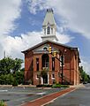
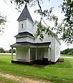
West Main Street Historic District (Chesterfield)
Finally, the West Main Street Historic District is another historic area in Chesterfield, South Carolina. It includes parts of West Main, Church, and Academy Streets. This district was listed on May 4, 1982, completing the picture of Chesterfield's historic town center.
Images for kids
-
The Cheraw Town Hall, part of the Cheraw Historic District.
-
A view from the East Main Street Historic District in Chesterfield.
-

Image for the Evy Kirkley Site, whose location is restricted.
-
The historic Dr. Thomas E. Lucas House.
-
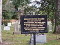
A grave in the cemetery of St. David's Episcopal Church.
-
The old Seaboard Air Line Railway Depot in McBee.
-
The historic Seaboard Air Line Railway Depot in Patrick.
-
Mount Tabor United Methodist Church, part of the West Main Street Historic District.


