Chesterfield County, South Carolina facts for kids
Quick facts for kids
Chesterfield County
|
|||
|---|---|---|---|

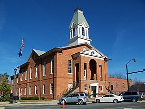
Old Chesterfield County Courthouse
|
|||
|
|||

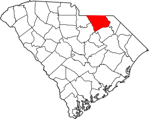
Location within the U.S. state of South Carolina
|
|||
 South Carolina's location within the U.S. |
|||
| Country | |||
| State | |||
| Founded | 1785 | ||
| Named for | Philip Dormer Stanhope, 4th Earl of Chesterfield | ||
| Seat | Chesterfield | ||
| Largest community | Cheraw | ||
| Area | |||
| • Total | 805.66 sq mi (2,086.6 km2) | ||
| • Land | 798.99 sq mi (2,069.4 km2) | ||
| • Water | 6.67 sq mi (17.3 km2) 0.83% | ||
| Population
(2020)
|
|||
| • Total | 43,273 | ||
| • Estimate
(2023)
|
44,031 | ||
| • Density | 54.16/sq mi (20.91/km2) | ||
| Time zone | UTC−5 (Eastern) | ||
| • Summer (DST) | UTC−4 (EDT) | ||
| Congressional district | 7th | ||
Chesterfield County is a county located in the state of South Carolina. It's a place where many people live and work. In 2020, about 43,273 people called it home. The main town, or county seat, is Chesterfield. The biggest community in the county is Cheraw. You can find Chesterfield County in the northern part of the Pee Dee region, right on the border with North Carolina.
Contents
History
Chesterfield County got its name from Philip Stanhope, 4th Earl of Chesterfield. He was a British politician who stood up for the American colonists. He was against the Stamp Act of 1765, which was a tax that made many people in South Carolina unhappy. He always spoke about the rights of the colonists in the British Parliament and when he was the British Secretary of State.
The county was officially created in 1785. Before 1800, it was part of a larger area called Cheraws District. After 1800, Chesterfield became its own district. In the 1700s, most of the people who settled here came from England and Wales. Some also came from County Antrim, Ireland. These Irish immigrants were mostly Presbyterians of Scottish background. They were often called "Scotch-Irish" by others, but they preferred to call themselves "Ulstermen" or "Irish Presbyterians."
After the American Civil War (1861–1865), a new state constitution was passed in 1867. This was during the Reconstruction era. This new rule meant that South Carolina districts, like Chesterfield, became counties and could make more of their own local decisions.
Geography
Chesterfield County covers a total area of about 806 square miles. Most of this area, about 799 square miles, is land. The remaining 6.7 square miles, which is about 0.8% of the total, is water.
Adjacent counties
Chesterfield County shares its borders with several other counties:
- Anson County, North Carolina - to the north
- Richmond County, North Carolina - to the northeast
- Marlboro County - to the east
- Darlington County - to the southeast
- Kershaw County - to the southwest
- Lancaster County - to the west
- Union County, North Carolina - to the northwest
National protected area
- Carolina Sandhills National Wildlife Refuge is a special natural area in the county.
Major highways
Many important roads run through Chesterfield County:
 US 1
US 1 US 52
US 52 US 601
 SC 9
SC 9 SC 20
SC 20 SC 32
SC 32 SC 80
SC 80 SC 102
 SC 109
 SC 145
 SC 151
 SC 207
 SC 265
 SC 268
 SC 903
Demographics
| Historical population | |||
|---|---|---|---|
| Census | Pop. | %± | |
| 1800 | 5,216 | — | |
| 1810 | 5,564 | 6.7% | |
| 1820 | 6,645 | 19.4% | |
| 1830 | 8,472 | 27.5% | |
| 1840 | 8,574 | 1.2% | |
| 1850 | 10,790 | 25.8% | |
| 1860 | 11,834 | 9.7% | |
| 1870 | 10,584 | −10.6% | |
| 1880 | 16,345 | 54.4% | |
| 1890 | 18,468 | 13.0% | |
| 1900 | 20,401 | 10.5% | |
| 1910 | 26,301 | 28.9% | |
| 1920 | 31,969 | 21.6% | |
| 1930 | 34,334 | 7.4% | |
| 1940 | 35,963 | 4.7% | |
| 1950 | 36,236 | 0.8% | |
| 1960 | 33,717 | −7.0% | |
| 1970 | 33,667 | −0.1% | |
| 1980 | 38,161 | 13.3% | |
| 1990 | 38,577 | 1.1% | |
| 2000 | 42,768 | 10.9% | |
| 2010 | 46,734 | 9.3% | |
| 2020 | 43,273 | −7.4% | |
| 2023 (est.) | 44,031 | −5.8% | |
| U.S. Decennial Census 1790–1960 1900–1990 1990–2000 2010 2020 |
|||
2020 census
In 2020, the county had 43,273 people living there. There were 17,900 households and 12,399 families. Most people, about 59.7%, were White. About 30.4% were Black or African American. Other groups included Native American, Asian, Pacific Islander, and people of mixed races. About 4.8% of the population was Hispanic or Latino.
2010 census
Back in 2010, there were 46,734 people living in Chesterfield County. The population density was about 58.5 people per square mile. The main groups were White (62.8%) and Black or African American (32.6%). About 34.7% of households had children under 18. The average age of people in the county was 39.3 years old.
Economy
In 2022, the total value of all goods and services produced in Chesterfield County was about $1.7 billion. This means the county's economy is quite active. The unemployment rate, which is the percentage of people looking for jobs who can't find them, has been between 2% and 4.5% from 2022 to 2024.
As of April 2024, some of the biggest employers in the county include well-known companies like Black+Decker and Walmart. Other important employers are the Chesterfield County School District, Crown Holdings, McLeod Health, and Northeastern Technical College. These businesses and organizations provide many jobs for the people living in the county.
Education
Students in Chesterfield County go to schools within the Chesterfield County School District. There is also a private school called South Point Christian School in Pageland, which teaches students from Kindergarten all the way through 12th grade.
For higher education, Northeastern Technical College has campuses in Pageland and Cheraw.
High schools
- Central High School, Pageland
- Cheraw High School, Cheraw
- Chesterfield High School, Chesterfield
- McBee High School, McBee
Middle schools
- Chesterfield/Ruby Middle School, Chesterfield/Ruby
- Long Middle School, Cheraw
- New Heights Middle School, Jefferson
Elementary schools
- Cheraw Intermediate School, Cheraw
- Edwards Elementary School, Chesterfield
- Jefferson Elementary School, Jefferson
- McBee Elementary School, McBee
- Pageland Elementary School, Pageland
- Plainview Elementary School, Plainview
- Ruby Elementary School, Ruby
Primary schools
- Cheraw Primary School, Cheraw
- Petersburg Primary School, Pageland
Culture
Chesterfield County has a lively arts scene. There are many groups that support fine arts, from high school marching bands to local theater groups and town arts commissions.
- The Central High Sound of Central
- The Cheraw Tribe Marching Band
- The Chesterfield Marching Pride
- The Spirit of McBee High Marching Band
- The Cheraw Arts Commission
- The Chesterfield Arts Commission
Recreation
There are lots of fun things to do for recreation in Chesterfield County. Each town offers different activities, but you can commonly find baseball and softball fields, walking tracks, parks, and other outdoor spaces. Golf is very popular, and many people from the region visit the local golf courses. If you enjoy the outdoors, there's also plenty of hunting and fishing in the swampy areas of Black Creek and Lake Robinson.
Communities
Towns
- Cheraw
- Chesterfield (county seat)
- Jefferson
- McBee
- Mount Croghan
- Pageland
- Patrick
- Ruby
Unincorporated communities
These are smaller communities that are not officially towns:
- Angelus
- Cash
- Middendorf
- Minden
See also
 In Spanish: Condado de Chesterfield (Carolina del Sur) para niños
 | Precious Adams |
 | Lauren Anderson |
 | Janet Collins |


