Ruby, South Carolina facts for kids
Quick facts for kids
Ruby, South Carolina
|
||
|---|---|---|
|
||
| Nickname(s):
Jewel City
|
||

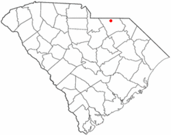
Location of Ruby, South Carolina
|
||
| Country | United States | |
| State | South Carolina | |
| County | Chesterfield | |
| Area | ||
| • Total | 2.47 sq mi (6.40 km2) | |
| • Land | 2.47 sq mi (6.40 km2) | |
| • Water | 0.00 sq mi (0.00 km2) | |
| Elevation | 387 ft (118 m) | |
| Population
(2020)
|
||
| • Total | 307 | |
| • Density | 124.34/sq mi (48.01/km2) | |
| Time zone | UTC-5 (Eastern (EST)) | |
| • Summer (DST) | UTC-4 (EDT) | |
| ZIP code |
29741
|
|
| Area code(s) | 843, 854 | |
| FIPS code | 45-62080 | |
| GNIS feature ID | 1250482 | |
Ruby is a small town located in Chesterfield County, South Carolina, in the United States. In 2020, about 307 people lived there. It is sometimes called the "Jewel City."
Contents
Discovering Ruby's Past
Ruby was first settled in 1875 and was originally called "Flint Hill." Like many towns nearby, it truly began to grow when the railroad was built through it.
How the Railroad Shaped Ruby
The Cheraw & Lancaster Railroad reached Ruby in 1902. This was a big deal because it made it easier to transport goods and people. The town was officially recognized and became incorporated in the same year the railroad arrived.
Ruby's Yearly Celebrations
Ruby is a town that loves to celebrate! Each year, residents enjoy two special events:
- The Jewel City Jubilee
- The Fourth of July Parade and Fireworks
Where is Ruby Located?
Ruby is found in the northern part of Chesterfield County. Its exact location is 34°44′44″N 80°10′33″W / 34.74556°N 80.17583°W.
Getting Around Ruby
South Carolina Highway 9 runs through the town. This highway can take you about 6 miles (10 km) east to Chesterfield, which is the main town of the county. If you go about 3 miles (5 km) northwest on Highway 9, you will reach Mount Croghan.
South Carolina Highway 109 also passes through Ruby. It travels west with SC 9 to Mount Croghan. If you head south from Ruby on Highway 109, it will take you about 8 miles (13 km) to Campbell Crossroads.
Ruby's Size and Land
According to the United States Census Bureau, Ruby covers a total area of about 2.47 square miles (6.4 square kilometers). All of this area is land, meaning there are no large lakes or rivers within the town limits.
Ruby's Population Over Time
| Historical population | |||
|---|---|---|---|
| Census | Pop. | %± | |
| 1910 | 194 | — | |
| 1920 | 290 | 49.5% | |
| 1930 | 326 | 12.4% | |
| 1940 | 337 | 3.4% | |
| 1950 | 315 | −6.5% | |
| 1960 | 284 | −9.8% | |
| 1970 | 306 | 7.7% | |
| 1980 | 256 | −16.3% | |
| 1990 | 300 | 17.2% | |
| 2000 | 348 | 16.0% | |
| 2010 | 360 | 3.4% | |
| 2020 | 307 | −14.7% | |
| U.S. Decennial Census | |||
The population of Ruby has changed over the years. In 2000, there were 348 people living in the town. By 2020, the population was 307.
Who Lives in Ruby?
In 2000, there were 157 households in Ruby. A household is a group of people living together in one home. About 26.8% of these households had children under 18 years old. Many households were made up of married couples.
Age Groups in Ruby
The people in Ruby come from all age groups. In 2000, about 20.1% of the population was under 18 years old. About 21.0% of the people were 65 years old or older. The average age in Ruby was 40 years.
See also
 In Spanish: Ruby (Carolina del Sur) para niños
 | Anna J. Cooper |
 | Mary McLeod Bethune |
 | Lillie Mae Bradford |


