Chesterfield, South Carolina facts for kids
Quick facts for kids
Chesterfield, South Carolina
|
||
|---|---|---|

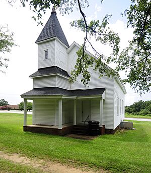
Mount Tabor United Methodist Church, pictured in August 2012
|
||
|
||
| Nickname(s):
The Heart of the Carolinas
|
||

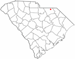
Location of Chesterfield, South Carolina
|
||
| Country | ||
| State | ||
| County | ||
| Area | ||
| • Total | 4.08 sq mi (10.56 km2) | |
| • Land | 4.08 sq mi (10.56 km2) | |
| • Water | 0.00 sq mi (0.00 km2) | |
| Elevation | 292 ft (89 m) | |
| Population
(2020)
|
||
| • Total | 1,357 | |
| • Density | 332.68/sq mi (128.45/km2) | |
| Time zone | UTC-5 (Eastern (EST)) | |
| • Summer (DST) | UTC-4 (EDT) | |
| ZIP code |
29709
|
|
| Area code(s) | 843, 854 | |
| FIPS code | 45-14140 | |
| GNIS feature ID | 1231164 | |
Chesterfield is a town in Chesterfield County, South Carolina, in the United States. It is the main town and county seat of Chesterfield County. This means it's where the county's government offices are located. In 2020, about 1,357 people lived here. It is the smallest county seat in South Carolina by population.
Contents
History of Chesterfield
Chesterfield has several important historic places. These places are listed on the National Register of Historic Places. This list helps protect old buildings and areas that are important to history.
- The East Main Street Historic District
- The Dr. Thomas E. Lucas House
- The West Main Street Historic District
These sites are looked after by the National Park Service. This service is part of the U.S. Department of the Interior.
Geography and Location
Chesterfield is located in the northeastern part of Chesterfield County. It covers an area of about 10.5 square kilometers (4.08 square miles). All of this area is land.
Several main roads pass through the town:
- South Carolina Highway 9 goes through Chesterfield. It leads east about 12 miles (19 km) to Cheraw. It goes west about 19 miles (31 km) to Pageland.
- South Carolina Highway 145 crosses SC 9 in the town center. It goes southwest about 21 miles (34 km) to McBee. It goes northeast about 10 miles (16 km) to Morven, North Carolina.
- South Carolina Highway 102 leads south from Chesterfield. It goes about 12 miles (19 km) to Patrick.
People of Chesterfield (Demographics)
Demographics is the study of people in a certain area. It looks at things like how many people live there and what their backgrounds are.
The population of Chesterfield has changed over the years:
| Historical population | |||
|---|---|---|---|
| Census | Pop. | %± | |
| 1900 | 308 | — | |
| 1910 | 618 | 100.6% | |
| 1920 | 856 | 38.5% | |
| 1930 | 1,030 | 20.3% | |
| 1940 | 1,263 | 22.6% | |
| 1950 | 1,530 | 21.1% | |
| 1960 | 1,532 | 0.1% | |
| 1970 | 1,667 | 8.8% | |
| 1980 | 1,432 | −14.1% | |
| 1990 | 1,373 | −4.1% | |
| 2000 | 1,318 | −4.0% | |
| 2010 | 1,472 | 11.7% | |
| 2020 | 1,357 | −7.8% | |
| U.S. Decennial Census | |||
2020 Census Information
In 2020, the 2020 United States census counted 1,357 people living in Chesterfield. There were 571 households and 406 families in the town.
The census also looks at the different backgrounds of people. Here's a quick look at the main groups in Chesterfield in 2020:
- About 65% of the people were White (not Hispanic).
- About 28.3% were Black or African American (not Hispanic).
- Smaller groups included Native American, Asian, and people of mixed backgrounds.
- About 1.3% of the people were Hispanic or Latino.
Education
Chesterfield has a public library. It is part of the Chesterfield County Library System. This means residents can borrow books, use computers, and find information there.
Geology
There is a special rock formation in the area called a "great syenite dyke." A dyke is like a wall of rock that cuts through older rocks. This one stretches from Hanging Rock through Taxahaw. It reaches the Brewer and Edgeworth mine in Chesterfield.
See also
 In Spanish: Chesterfield (Carolina del Sur) para niños
 | Sharif Bey |
 | Hale Woodruff |
 | Richmond Barthé |
 | Purvis Young |

