Cheraw, South Carolina facts for kids
Quick facts for kids
Cheraw
|
||
|---|---|---|
 |
||
|
||
| Motto(s):
"Industry ~ Progress ~ History ~ Beauty"
|
||

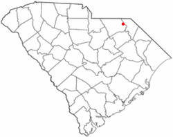
Location of Cheraw, South Carolina
|
||
| Country | United States | |
| State | South Carolina | |
| Counties | Chesterfield, Marlboro | |
| Government | ||
| • Type | Council-Manager | |
| Area | ||
| • Total | 5.99 sq mi (15.53 km2) | |
| • Land | 5.95 sq mi (15.42 km2) | |
| • Water | 0.04 sq mi (0.11 km2) | |
| Elevation | 167 ft (51 m) | |
| Population
(2020)
|
||
| • Total | 5,040 | |
| • Density | 846.63/sq mi (326.87/km2) | |
| Time zone | UTC-5 (Eastern (EST)) | |
| • Summer (DST) | UTC-4 (EDT) | |
| ZIP code |
29520
|
|
| Area code(s) | 843, 854 | |
| FIPS code | 45-13600 | |
| GNIS feature ID | 1247267 | |
Cheraw is a town located on the Pee Dee River in Chesterfield County, South Carolina, United States. In 2020, about 5,040 people lived there. The larger Cheraw area, including the 29520 zip code, had a population of 13,689 in 2019. Cheraw is sometimes called "The Prettiest Town in Dixie" because of its beauty.
Contents
History of Cheraw
Early Days
When the first Europeans arrived, the area was home to the Cheraw and Pee Dee Native American tribes. Sadly, new diseases brought by European traders greatly reduced their numbers by the 1730s. The remaining Cheraw joined the Catawba Confederacy for safety.
A few European settlers came in the 1730s. Later, people from Wales arrived and settled near Society Hill. Many early settlers in Cheraw in the 1740s were English, Scottish, French Huguenots, or Scots-Irish.
By 1750, Cheraw was a busy village with a growing river trade. It was one of the first inland villages shown on English maps of South Carolina. In the 1760s, Joseph and Eli Kershaw designed the town's main street system. By 1830, settlers had planted rows of elm trees along all the streets. The Kershaws first named the town "Chatham," but people continued to call it "Cheraw" or "Cheraw Hill."
The American Revolution
In the 1740s, there was little organization in the South Carolina backcountry. This made people unhappy with British rule. In the Pee Dee area, landowners formed a group called the Regulators to help keep order.
In 1768, St. David's Parish was built to serve the community. It was the last Anglican church built in South Carolina under King George III. Later, a court was set up to help with legal issues. Still, many people were unhappy. In May 1776, the grand jury of the Cheraws District declared its independence from Great Britain.
Many local men, like Claudius Pegues and General Henry W. Harrington, were important in the American Revolution. Cheraw was a key location for both sides. The British built garrisons there to control revolutionaries and support loyalists. Other important towns were Camden, South Carolina and Augusta, Georgia.
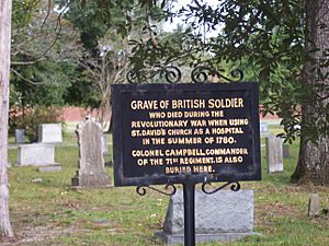
From 1780 to 1781, there was a lot of military action in Cheraw. During the war, St. David's Church was used as a hospital for British troops under Lord Cornwallis. It also housed the South Carolina militia. In December 1780, American General Nathanael Greene set up a "camp of repose" near Cheraw to rest and train his soldiers.
The 1800s
In 1819, the first steamboat arrived on the river. This brought more trade and wealth to Cheraw. The town officially became a town in 1820. The main crops grown in the Cheraw area were corn, cotton, tobacco, rice, and indigo.
Cheraw had the biggest cotton market between Georgetown, South Carolina and Wilmington, North Carolina. Because of the cotton trade, the town had the largest bank in South Carolina outside of Charleston before the Civil War. Even after a big fire in 1835, Cheraw was a busy and rich trading center by 1850.
The Civil War
Before the Civil War, people in Cheraw played a big part in South Carolina leaving the Union. On November 19, 1860, the first public call for secession happened at the Chesterfield County Courthouse. John A. Inglis of Cheraw was there. He later suggested that South Carolina should secede. Inglis also led the group that wrote the document for South Carolina's secession.
During the war, Cheraw was known as a safe place to store valuable items. In March 1865, General William T. Sherman and his Union troops came to Cheraw for several days. The town was important because of its bridge over the Pee Dee River. Confederate forces slowed Sherman's army by destroying the bridge as they left Cheraw.
One Union soldier said Cheraw was "a pleasant town and an old one with the Southern aristocratic bearing." Sherman used this time to get more control over his men. No homes or public buildings in Cheraw were destroyed by Sherman's troops. However, an accidental explosion of captured gunpowder near the river burned down Cheraw's business district. The county courthouse in Chesterfield also burned, causing many old records to be lost. This makes it hard to know the exact age of many historic buildings.
During the Civil War, St. David's Church was used as a hospital by both the Confederate and Union armies. Some soldiers from both sides were buried there. The first Confederate monument was put up there in 1867.
From 1900 to Today
The Civil War caused many problems for Cheraw, especially with the bridge destroyed and the business area burned. But by the early 1900s, Cheraw started to become successful again. The Colored Memorial School was also started in Cheraw.
The Great Depression in the 1930s brought more changes. Cheraw State Park and Sandhills State Forest were created. Cheraw was the first town in South Carolina to use the Civilian Conservation Corps (CCC) to build a state park. The town's citizens paid for the plan, hoping to make Cheraw the "Gateway City" of South Carolina. Cheraw State Park is the largest state park in South Carolina built by the CCC.
By the 1950s and 1960s, the town began to grow with new industries. By the end of the 20th century, Cheraw had a good mix of industries while keeping its historic charm and natural beauty. The harbor tug USS Cheraw was named after the town.
In November 1941, Cheraw even saw a pretend battle during the Carolina Maneuvers. General George Patton's tanks entered the town, and it was decided they were successful.
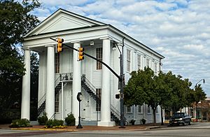
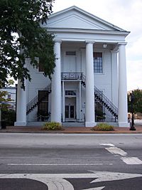
Besides St. David's Episcopal Church and Cemetery, the Cheraw Historic District and Robert Smalls School are important places listed on the National Register of Historic Places.
Cheraw's Location
Cheraw is in the eastern part of Chesterfield County, where the land changes from hilly to flat near the Pee Dee River. This area is called the fall line. The town covers about 15.53 square kilometers (5.99 square miles). Most of this is land, with a small amount of water.
U.S. Route 1 goes through the center of Cheraw. It leads northeast to Rockingham, North Carolina, and southwest to Camden. U.S. Route 52 also joins US 1 in Cheraw. It goes northwest to Wadesboro, North Carolina, and south to Florence. South Carolina Highway 9 also passes through Cheraw, leading southeast to Bennettsville and west to Chesterfield, which is the main town of the county.
People in Cheraw
| Historical population | |||
|---|---|---|---|
| Census | Pop. | %± | |
| 1880 | 918 | — | |
| 1890 | 976 | 6.3% | |
| 1900 | 1,151 | 17.9% | |
| 1910 | 2,873 | 149.6% | |
| 1920 | 3,150 | 9.6% | |
| 1930 | 3,573 | 13.4% | |
| 1940 | 4,497 | 25.9% | |
| 1950 | 4,836 | 7.5% | |
| 1960 | 5,171 | 6.9% | |
| 1970 | 5,627 | 8.8% | |
| 1980 | 5,654 | 0.5% | |
| 1990 | 5,505 | −2.6% | |
| 2000 | 5,524 | 0.3% | |
| 2010 | 5,851 | 5.9% | |
| 2020 | 5,040 | −13.9% | |
| U.S. Decennial Census | |||
2020 Census Information
In 2020, there were 5,040 people living in Cheraw. There were 2,358 households and 1,499 families.
| Race | Num. | Perc. |
|---|---|---|
| White (non-Hispanic) | 1,962 | 38.93% |
| Black or African American (non-Hispanic) | 2,641 | 52.4% |
| Native American | 15 | 0.3% |
| Asian | 76 | 1.51% |
| Pacific Islander | 2 | 0.04% |
| Other/Mixed | 219 | 4.35% |
| Hispanic or Latino | 125 | 2.48% |
Schools in Cheraw
- Cheraw Primary School
- Cheraw Intermediate School
- Long Middle School
- Cheraw High School
- St. Davids School (preK3 to kindergarten)
- Faith Christian Academy
- Jesus Is Lord Christian School
Famous People from Cheraw
- Patrick N. L. Bellinger, a pioneer in naval aviation
- Tom Brewer, former professional baseball pitcher
- Jaron Brown, NFL wide receiver
- William Little Brown, a justice on the Tennessee Supreme Court
- William P. Burch, U.S. Racing Hall of Fame horse trainer
- Joe Cheves, former professional golfer
- Fisher DeBerry, College Football Hall of Fame coach
- Charles F. Duvall, a bishop
- Pembroke Finlayson, former professional baseball pitcher
- Ty Gainey, former professional baseball outfielder
- Dizzy Gillespie, famous jazz trumpet player and composer
- Henry Gillespie, Negro league pitcher
- George W. Gregory Jr., former South Carolina politician
- Andy Hall, former NFL quarterback
- Dale Hatcher, former NFL punter
- Jimmy Ingram, pilot and NASCAR driver
- Parson James, singer/songwriter
- Joyce Krawiec, North Carolina politician
- Abraham Cohen Labatt, a pioneer of Reform Judaism
- Patrick Neeson Lynch, a Roman Catholic bishop
- Donald Malloy, gospel singer/musician
- Kenneth G. Matheson, former professor and chancellor
- Cliff Matthews, NFL defensive end/defensive tackle
- Julius McCoy, former professional basketball player
- Henry McIver, former chief justice on the South Carolina Supreme Court
- Doc McJames, former professional baseball pitcher
- Virginia McLaurin, community volunteer and supercentenarian
- Robert L. McLeod, pastor and academic administrator
- Frank Motley, R&B and jazz musician
- Harry Newsome, former NFL punter
- Philip Phillips (lawyer), lawyer and politician
- William P. Pollock, United States Senator
- Shawn Short, dance choreographer
- William Francis Stevenson, former mayor of Cheraw and US congressman
- David Thornton, actor
- Ted Vick, South Carolina politician
- Richie Yow, South Carolina politician
See also
 In Spanish: Cheraw (Carolina del Sur) para niños
 | Delilah Pierce |
 | Gordon Parks |
 | Augusta Savage |
 | Charles Ethan Porter |


