Jefferson, South Carolina facts for kids
Quick facts for kids
Jefferson, South Carolina
|
|
|---|---|

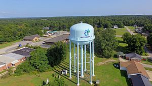
Water tower, 2011
|
|
| Nickname(s):
"J-Town"
|
|
| Motto(s):
“A small town with big city dreams”
|
|

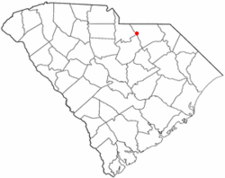
Location of Jefferson, South Carolina
|
|
| Country | United States |
| State | South Carolina |
| County | Chesterfield |
| Incorporated | 1904 |
| Government | |
| • Type | Council |
| Area | |
| • Total | 1.81 sq mi (4.68 km2) |
| • Land | 1.80 sq mi (4.67 km2) |
| • Water | 0.01 sq mi (0.01 km2) |
| Elevation | 476 ft (145 m) |
| Population
(2020)
|
|
| • Total | 772 |
| • Density | 428.41/sq mi (165.40/km2) |
| Time zone | UTC−5 (Eastern (EST)) |
| • Summer (DST) | UTC−4 (EDT) |
| ZIP code |
29718
|
| Area code(s) | 843, 854 |
| FIPS code | 45-36610 |
| GNIS feature ID | 1223522 |
| Website | http://www.seejeffersonsc.com |
Jefferson is a small town in Chesterfield County, South Carolina, United States. It is located where two main roads, SC 265 and SC 151, meet. The town is in the Piedmont region of South Carolina, which is a hilly area. It sits right where the Piedmont meets the Sandhills region.
Jefferson is about 16 miles northwest of McBee and 8 miles south of Pageland. It is also about 50 miles southeast of Charlotte, North Carolina. The state capital, Columbia, is about 70 miles north-northeast of Jefferson. In 2010, about 753 people lived in Jefferson. By 2020, the population grew slightly to 772 people.
Contents
History of Jefferson
Jefferson became an official town in 1904. This means it was formally recognized and could set up its own local government.
Geography and Climate
Jefferson is located at coordinates 34.651550° N, 80.389484° W. The town covers a total area of about 1.8 square miles (4.7 square kilometers). Most of this area is land, with only a very small part being water.
Towns Near Jefferson
Jefferson is surrounded by several other towns. Here are some of them:
- Pageland is to the North.
- Waxhaw is to the Northwest.
- Mount Croghan is to the Northeast.
- Chesterfield is to the East.
- McBee is to the Southeast.
- Bethune is to the South.
- Kershaw is to the Southwest.
- Lancaster is to the West.
 |
Waxhaw | Pageland | Mount Croghan |  |
| Lancaster | Chesterfield | |||
| Kershaw | Bethune | McBee |
The Brewer Gold Mine
The Brewer Gold Mine is an old mine located near Jefferson. It is about 1.5 miles west of the town. The mine property covers about 1,000 acres of land. This land is along a small ridge that separates two creeks. About a quarter of this land has been changed by mining activities.
The Brewer Gold Mine was one of the oldest and most successful gold mines in the eastern United States. People say that mining activities here might have started as early as the 1500s. At that time, Native Americans might have traded with the Spanish. Before the American Revolutionary War, people mined for iron in this area.
The first official discovery of gold happened in 1828 by Burrell Brewer. A company called Brewer Gold Company took ownership of the mine in 1986. They started producing gold in August 1987. They dug for ore using a method called "open pit mining" until 1995. This means they dug a large hole in the ground to get the ore. They used drilling and blasting to break up the rock. Then, trucks carried the rock away.
The ore was then crushed. After crushing, it was placed on special pads. A weak cyanide solution was sprayed over the crushed ore. This solution would slowly drip through the ore, dissolving the gold.
Pine Cones and Pine Straw
Pine trees are very important to the local economy in Jefferson. Long-leaf and loblolly pine trees grow here. These trees drop their cones and needles. In 2015, a company called Casey Horton Enterprises started collecting these.
Pine cones are often used for Christmas decorations. Pine straw, which are the fallen needles, is used in yards as a type of mulch. It helps keep plants healthy. Horton Enterprises now mostly focuses on the pine cone business.
Population Information
| Historical population | |||
|---|---|---|---|
| Census | Pop. | %± | |
| 1910 | 390 | — | |
| 1920 | 454 | 16.4% | |
| 1930 | 499 | 9.9% | |
| 1940 | 547 | 9.6% | |
| 1950 | 556 | 1.6% | |
| 1960 | 493 | −11.3% | |
| 1970 | 709 | 43.8% | |
| 1980 | 651 | −8.2% | |
| 1990 | 745 | 14.4% | |
| 2000 | 704 | −5.5% | |
| 2010 | 753 | 7.0% | |
| 2020 | 772 | 2.5% | |
| U.S. Decennial Census | |||
The United States Census counts how many people live in an area every ten years. In 2020, there were 772 people living in Jefferson. These people lived in 350 households, and 248 of these were families.
Fun and Activities
The Jefferson Recreation Complex is a public park located on Ogburn Drive. It has many uses, including five baseball fields. In 2012, about 400 young people from ages three to 15 played on 26 different baseball teams there. They even built a press box and restrooms at the complex.
Schools and Learning
Public schools in Jefferson are managed by the Chesterfield County School District. The district runs Jefferson Elementary School and New Heights Middle School. Older students attend Central High School. For higher education, Northeastern Technical College offers college courses.
Jefferson also has a public library. It is a part of the Chesterfield County Library System, which means it's connected to other libraries in the county.
Health Services
Sandhills Medical Foundation is a health center that helps people in Jefferson and nearby counties. It serves residents of Chesterfield, Kershaw, Lancaster, and Sumter counties. This foundation was started in 1977 to provide healthcare to the community.
See also
 In Spanish: Jefferson (Carolina del Sur) para niños
 | Bayard Rustin |
 | Jeannette Carter |
 | Jeremiah A. Brown |


