
National Register of Historic Places listings in Claiborne County, Mississippi facts for kids

Welcome to a special list of amazing places in Claiborne County, Mississippi! These are places that are so important, they've been added to the National Register of Historic Places. Think of it like a Hall of Fame for buildings, sites, and areas that tell us a lot about history.
In Claiborne County, there are 36 of these special spots. Two of them are even more important and are called National Historic Landmarks. This list helps us remember and protect these important parts of our past.
Historic Places in Claiborne County
This section lists the many historic places you can find in Claiborne County. Each one has a unique story!
| Name on the Register | Image | Date listed | Location | City or town | Description | |
|---|---|---|---|---|---|---|
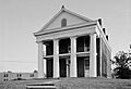
| 1 | Alcorn State University Historic District |
 |
(#82003098) |
Alcorn State University campus 31°52′32″N 91°08′59″W / 31.875556°N 91.149722°W |
Lorman | This district includes many historic buildings on the campus of Alcorn State University. It's a very old university, founded in 1871. |
| 2 | Bayou Pierre Site |
(#78001596) |
Address Restricted |
Port Gibson | This is an important archaeological site. It helps us learn about early human history in the area. | |
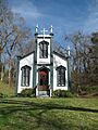
| 3 | Bethel Presbyterian Church |
 |
(#78001594) |
North of Alcorn on Mississippi Highway 552 31°54′21″N 91°07′44″W / 31.905833°N 91.128889°W |
Alcorn | This historic church building has been a part of the community for a long time. It shows us what churches looked like in the past. |
| 4 | Buena Vista Cotton Gin |
(#74001059) |
Northeast of Port Gibson 31°59′23″N 90°54′35″W / 31.9897°N 90.9097°W |
Port Gibson | A cotton gin was a machine that separated cotton fibers from their seeds. This one is a historic example of how cotton was processed. | |
| 5 | Building at 801 Chinquepin Street |
(#79003420) |
801 Chinquepin St. 31°57′18″N 90°58′41″W / 31.955°N 90.978056°W |
Port Gibson | This building is a good example of the architecture from its time. It helps preserve the look of old Port Gibson. | |
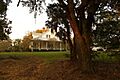
| 6 | Canemount |
 |
(#82000572) |
North of Alcorn off Mississippi Highway 552 31°53′40″N 91°07′34″W / 31.894444°N 91.126111°W |
Alcorn | Canemount is a historic plantation house. It shows us how large homes were built in the past. |
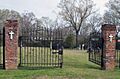
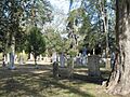
| 7 | Catholic Cemetery |
 |
(#79003425) |
700 Coffee St. 31°57′21″N 90°58′43″W / 31.955833°N 90.978611°W |
Port Gibson | This cemetery is a historic burial ground. It holds the stories of many people who lived in the area long ago. |
| 8 | Catledge Archeological Site |
(#74001058) |
Address Restricted |
Alcorn | Another important archaeological site. It helps experts understand ancient cultures and how people lived. | |
| 9 | Centers Creek Mound |
(#73001003) |
Address Restricted |
Russum | This mound is an ancient earthwork. It was likely built by Native Americans many centuries ago. | |
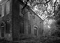
| 10 | Chamberlain-Hunt Academy Historic District |
 |
(#79003411) |
Roughly bounded by U.S. Route 61, the city limits, Woodstock St., and Mississippi Highway 547 31°56′43″N 90°59′12″W / 31.945278°N 90.986667°W |
Port Gibson | This historic district includes the buildings of the former Chamberlain-Hunt Academy. It was an important school for many years. |
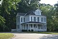
| 11 | Claremont |
(#79003418) |
366 Claremont Dr. 31°56′59″N 90°59′33″W / 31.949722°N 90.9925°W |
Port Gibson | Claremont is a historic home in Port Gibson. It represents the style of houses built in the area long ago. | |
| 12 | Collina |
 |
(#79003419) |
Greenwood St. Extension 31°57′15″N 90°59′25″W / 31.954167°N 90.990278°W |
Port Gibson | Collina is another historic plantation. It's a great example of the large estates that existed in Mississippi. |
| 13 | Drake Hill Historic District |
(#79003412) |
Drake Hill Rd. 31°57′36″N 90°59′17″W / 31.96°N 90.988056°W |
Port Gibson | This district includes a collection of historic buildings on Drake Hill Road. They show the history of the neighborhood. | |
| 14 | Golden West Cemetery |
(#79003417) |
Rodney Rd. 31°57′26″N 90°59′30″W / 31.957222°N 90.991667°W |
Port Gibson | This historic cemetery is a quiet place that tells stories of the past through its old gravestones. | |
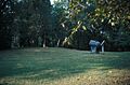
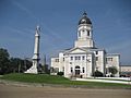
| 15 | Grand Gulf Military State Park |
 |
(#72000689) |
6 miles west of Port Gibson 31°31′58″N 91°03′00″W / 31.532778°N 91.05°W |
Port Gibson | This park was once a busy port and a site of Civil War battles. It's now a place to learn about that history. |
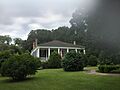
| 16 | Idlewild |
 |
(#79003416) |
310 Idlewild Dr. 31°57′00″N 90°59′14″W / 31.95°N 90.987222°W |
Port Gibson | Idlewild is a beautiful historic home built in 1833. It shows the grand style of homes from that era. |
| 17 | Jewish Cemetery |
 |
(#79003415) |
900 Marginal St. 31°57′22″N 90°58′45″W / 31.956111°N 90.979167°W |
Port Gibson | This cemetery is a historic burial site for the Jewish community in Port Gibson. It reflects the diverse history of the town. |
| 18 | Market Street-Suburb Ste. Mary Historic District |
 |
(#79003410) |
Roughly bounded by Orange, Marginal, Greenwood, and Market Sts. 31°57′27″N 90°58′56″W / 31.9575°N 90.982222°W |
Port Gibson | This district covers a part of Port Gibson with many old buildings. It shows how the town grew and developed. |
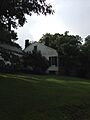
| 19 | McGregor |
(#79003424) |
Mississippi Highway 547 31°56′32″N 90°58′37″W / 31.942222°N 90.976944°W |
Port Gibson | McGregor is a historic property that adds to the rich history of homes in the Port Gibson area. | |
| 20 | John Nelson Site |
(#74001060) |
Address Restricted |
Willows | This is an archaeological site. It helps us understand the ancient people who lived here. | |
| 21 | Oakland Chapel |
.jpg) |
(#74001057) |
Alcorn State University campus 31°52′33″N 91°08′22″W / 31.875833°N 91.139444°W |
Alcorn | Oakland Chapel is a very important building on the Alcorn State University campus. It's a National Historic Landmark. |
| 22 | Old Brickyard Place |
(#79003423) |
Anthony St. 31°58′09″N 90°59′29″W / 31.969167°N 90.991389°W |
Port Gibson | This site was once a brickyard, where bricks were made for building. It shows an important industry from the past. | |
| 23 | Old Depot Restaurant and Lounge |
 |
(#79003421) |
1202 Market St. 31°57′20″N 90°59′15″W / 31.955556°N 90.9875°W |
Port Gibson | This building was once a train depot. It played a role in transportation and trade in Port Gibson. |
| 24 | Old Natchez Trace (132-3T) |
 |
(#76000161) |
Northeast of Port Gibson at milepost 45.8 of the Natchez Trace Parkway 32°00′10″N 90°53′46″W / 32.002778°N 90.896111°W |
Port Gibson | This is a piece of the original Natchez Trace, an ancient path used by Native Americans and early settlers. |
| 25 | Owens Creek Bridge |
(#88002398) |
Spans Owen Creek on an old county road 32°05′29″N 90°43′45″W / 32.091389°N 90.729167°W |
Utica | This historic bridge crosses Owens Creek. It's an example of old bridge building techniques. | |
| 26 | Port Gibson Battle Site |
(#05000461) |
West of Port Gibson 31°57′28″N 91°01′08″W / 31.9578°N 91.0189°W |
Port Gibson | This site is where the Battle of Port Gibson took place during the Civil War. It's a National Historic Landmark. | |
| 27 | Port Gibson Battlefield |
(#72000690) |
4 miles west of Port Gibson 31°57′28″N 91°01′08″W / 31.957778°N 91.018889°W |
Port Gibson | This is the larger area of the Port Gibson Battlefield. It helps us understand the important events of the Civil War. | |
| 28 | Port Gibson High School (Old) |
(#16000285) |
161 Ramsey Dr. 31°57′07″N 90°59′13″W / 31.952075°N 90.986971°W |
Port Gibson | This building was once the high school for Port Gibson. It's a reminder of how education has changed over time. | |
| 29 | Port Gibson Oil Works Mill Building |
(#79003422) |
Anthony St. 31°57′54″N 90°59′25″W / 31.965°N 90.990278°W |
Port Gibson | This mill building was part of an oil works. It shows us about the industries that were important in the past. | |
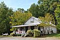
| 30 | Sacred Heart Roman Catholic Church |
 |
(#73002241) |
Grand Gulf Military Monument Park 32°02′00″N 91°03′11″W / 32.033333°N 91.053056°W |
Port Gibson | This historic church is located within the Grand Gulf Military State Park. It's a beautiful example of religious architecture. |
| 31 | Smithfield Site |
(#78001595) |
Address Restricted |
Bruinsburg | The Smithfield Site is an archaeological location. It helps scientists learn about ancient human activity. | |
| 32 | Valley of the Moon Bridge |
(#05000561) |
Willows Rd. at its crossing of Bayou Pierre, 2 miles southeast of Willows 32°01′03″N 90°52′37″W / 32.0175°N 90.876944°W |
Port Gibson | This bridge crosses Bayou Pierre. It's a historic structure that shows how bridges were built in the early 20th century. | |
| 33 | Van Dorn House |
.jpg) |
(#71000446) |
Van Dorn Dr. 31°56′24″N 91°02′15″W / 31.94°N 91.0375°W |
Port Gibson | The Van Dorn House is a historic home. It's a great example of the architecture from its time period. |
| 34 | Widow's Creek Bridge |
(#88002409) |
Spans Widow's Creek on a county road 31°56′30″N 91°03′03″W / 31.941667°N 91.050833°W |
Port Gibson | This bridge crosses Widow's Creek. It's a historic structure that shows old engineering methods. | |
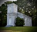
| 35 | Windsor Ruins |
 |
(#71000447) |
12 miles southwest of Port Gibson on Mississippi Highway 552 31°56′26″N 91°07′46″W / 31.94056°N 91.12944°W |
Port Gibson | The Windsor Ruins are the remains of a grand mansion. It was destroyed by fire but its columns still stand tall. |
| 36 | Windsor Site |
(#79003126) |
Address Restricted |
Port Gibson | This site is connected to the historic Windsor mansion. It helps us understand the full history of the area. | |
| 37 | Wintergreen Cemetery |
 |
(#79003414) |
E. Greenwood St. 31°57′05″N 90°58′45″W / 31.951389°N 90.979167°W |
Port Gibson | Wintergreen Cemetery is a historic burial ground. It's a peaceful place that tells stories of the past. |
Former Listings
Sometimes, a historic place might be removed from the National Register. This usually happens if the building is destroyed or changes too much.
| Name on the Register | Image | Date listed | Date removed | Location | City or town | Summary | |
|---|---|---|---|---|---|---|---|
| 1 | Hollyrood |
(#79003413) |
|
Old Hwy. 61 S |
Port Gibson | Hollyrood was a historic property once listed on the Register. It was removed in 1992. |
Images for kids
-
The Literary Society Building at Alcorn State University.
-
Bethel Presbyterian Church, a historic place of worship.
-
The beautiful Canemount Plantation house.
-
The historic Catholic Cemetery in Port Gibson.
-
The President's House at the former Chamberlain-Hunt Academy.
-
Collina Plantation, a grand historic estate.
-
Grand Gulf Military State Park, important for Civil War history.
-
Idlewild, a historic home built in 1833.
-
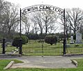
The Jewish Cemetery in Port Gibson.
-
A view from the Market Street-Suburb Ste. Mary Historic District.
-
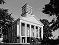
Oakland Chapel, a National Historic Landmark at Alcorn State University.
-

The Old Depot Restaurant and Lounge, once a train station.
-
A section of the Old Natchez Trace.
-
Sacred Heart Roman Catholic Church at Grand Gulf Military State Park.
-
The historic Van Dorn House.
-

The impressive Windsor Ruins.
-
Wintergreen Cemetery, a historic burial ground.
