
Bruinsburg, Mississippi facts for kids
Quick facts for kids
Bruinsburg, Mississippi
|
|
|---|---|
.jpg)
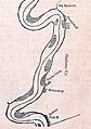
1840 map of Mississippi River showing Grand Gulf, Bruinsburg, and Rodney
|
|

Bruinsburg, Mississippi
Location in Mississippi

Bruinsburg, Mississippi
Location in the United States
|
|
| Country | |
| State | |
| County | Claiborne |
| Elevation | 24 m (79 ft) |
| Time zone | UTC-6 (Central (CST)) |
| • Summer (DST) | UTC-5 (CDT) |
| GNIS feature ID | 691732 |
Bruinsburg is a former town in Claiborne County, Mississippi, United States. It was founded when the Natchez District was part of West Florida. This settlement was one of the main stopping points on the Natchez Trace. This was a famous land route that connected Nashville to the lower Mississippi River valley.
Bruinsburg was located on the south bank of Bayou Pierre. This is about 3 miles (4.8 km) east of the Mississippi River. The town's port, called Bruinsburg Landing, was right on the Mississippi River. It was just south of where Bayou Pierre met the river.
Once, Bruinsburg was a very important place for trade and military actions. Today, nothing is left of the town or its port.
Contents
History of Bruinsburg
Bruinsburg is named after Peter Bryan Bruin. He moved from Ireland to Virginia in 1756. Later, he fought as a lieutenant in the American Revolution. After the war, Bruin's father received a large piece of land in Mississippi. This land was given by Don Diego de Gardoqui, a Spanish minister. At that time, this area was called Spanish West Florida.
Peter Bruin's family and 12 other families moved there in 1778. They had to survey the land and clear trees. They also built cabins and planted crops. Soon, the settlers were growing corn, cotton, tobacco, and fruits. Lake Bruin, a lake in Louisiana, is also named after Peter Bruin.
The community became a busy port on the Mississippi River. Andrew Jackson, who later became a U.S. President, had a trading post here in the 1790s. He was involved in the business of moving enslaved people from Nashville to sell them in the Natchez District or New Orleans.
After the southern United States became part of America, Bruin was made a judge. In 1807, Aaron Burr, a former Vice-President, visited Bruin. Burr was trying to avoid federal agents at the time. By 1848, Bruinsburg was described as just a "small place" in a river guide.
Bruinsburg in the Civil War
During the American Civil War, Union Army General Ulysses S. Grant planned a huge attack. He wanted to capture the Confederate stronghold of Vicksburg, Mississippi. Grant first tried to land his army at Grand Gulf, Mississippi, but it didn't work.
On April 29, 1863, he arrived at Disharoon's Plantation in Louisiana. This was about 5 miles (8 km) north of Bruinsburg. Grant planned to land his troops further downstream at Rodney, Mississippi. But late that night, an escaped enslaved person told Grant about Bruinsburg. It was much closer and had a great steamboat landing. It also had a good road leading up from the river.
The next day, 17,000 Union soldiers started landing at Bruinsburg. This was the start of the Battle of Port Gibson. This battle was part of the larger Vicksburg Campaign. Because river travel had slowed down during the war, the port was almost empty when the soldiers arrived. Only one farmer was there, and he seemed too confused to run away.
The port was perfect for landing troops and many boats. This was the largest water-to-land military operation in American history until the Normandy landings in World War II.
General Grant later wrote about this moment:
When this was accomplished I felt a degree of relief scarcely ever equaled since. Vicksburg was not yet taken it is true...but, I was on dry ground on the same side of the river with the enemy.
—Ulysses S. Grant
The soldiers then moved east along the dusty roads from Bruinsburg. They rested under the trees of the nearby Windsor Plantation. That evening, they began their march north.
Bruinsburg in the 20th and 21st Centuries

Around 1913, Bruinsburg still had a boat landing and a post office.
Today, the former town and its landing are on private land. You can find a historic plaque that remembers Bruinsburg in Port Gibson.
Images for kids
-
1840 map of Mississippi River showing Grand Gulf, Bruinsburg, and Rodney
