
National Register of Historic Places listings in Clay County, Missouri facts for kids

Have you ever wondered about the old buildings and places around you? Some of them are so important that they are listed on the National Register of Historic Places! This is a special list kept by the United States government to protect and celebrate places that have a big part in American history, architecture, archaeology, engineering, or culture.
Clay County, Missouri, is home to many of these amazing historic sites. There are 39 places in Clay County that are on this special list, including one that is even more important: a National Historic Landmark. These places help us learn about the past and understand how people lived and worked long ago.
Contents
Famous Homes and Farms
Clay County has several homes and farms that tell us stories about the people who lived there.
James Brothers' House and Farm
One of the most famous places is the James Brothers' House and Farm near Kearney. This was the childhood home of Jesse and Frank James, who were well-known outlaws in the American Old West. The farm helps us understand what life was like for families in Missouri during the 1800s. It's a place where history, and even some legends, come alive!
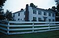
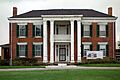
Claybrook House
Also near Kearney is the Claybrook House. This historic home gives us a peek into the past, showing us the style of houses and the way people lived in rural Clay County many years ago.
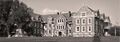
Woodneath
In Kansas City, you can find Woodneath. This old home is another example of the beautiful and historic buildings that have been preserved in Clay County, showing us different architectural styles from the past.
Historic Hotels and Health Resorts
Excelsior Springs was once a very popular place for people to visit for their health. Many believed the natural spring waters had healing powers. Because of this, several grand hotels and buildings were built there.
Elms Hotel
The Elms Hotel in Excelsior Springs is a beautiful and historic hotel. It was a famous resort where people came to relax and enjoy the mineral waters. The hotel has hosted many important guests over the years and is known for its grand style and long history.
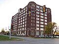
Hall of Waters
Another very important building in Excelsior Springs is the Hall of Waters. This unique building was designed to offer different types of mineral water to visitors. It was a central part of the town's identity as a health resort and is known for its interesting architecture. It's a great example of how people used to seek natural remedies for their health.
Colonial Hotel
The Colonial Hotel is another historic hotel in Excelsior Springs. It adds to the story of the town's past as a popular health and wellness destination, showing the different places where visitors would stay.
Important Public and Commercial Buildings
Many buildings in Clay County were important for business, education, or community life.
Clay County Savings Association Building
In Liberty, the Clay County Savings Association Building is a significant historic structure. It shows us what banks and financial buildings looked like in the past and how they served the community.
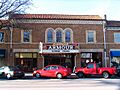
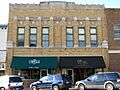
Armour Theatre Building
The Armour Theatre Building in North Kansas City is a historic theater. Theaters were important places for entertainment and community gatherings, and this building reminds us of how people enjoyed themselves in earlier times.
Frank Hughes Memorial Library
The Frank Hughes Memorial Library in Liberty is a historic library building. Libraries have always been important centers for learning and knowledge in communities.
IOOF Liberty Lodge No. 49
Also in Liberty, the IOOF Liberty Lodge No. 49 building was home to a local chapter of the Independent Order of Odd Fellows, a fraternal organization. These lodges were important social and charitable groups in the past.
Missouri City Savings Bank Building and Meeting Hall
The Missouri City Savings Bank Building and Meeting Hall in Missouri City served as both a bank and a place for community meetings. It shows how important these buildings were for daily life and local events.
Sears, Roebuck and Company Warehouse Building
In North Kansas City, the Sears, Roebuck and Company Warehouse Building is a large historic warehouse. It represents the growth of big businesses and how goods were stored and distributed a long time ago.
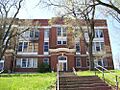
Wyman School
The Wyman School in Excelsior Springs is an old school building. Schools are always important parts of a community, and this historic building reminds us of how education was provided in the past.
Historic Districts
Some areas have many historic buildings close together. These are called "historic districts."
Arthur-Leonard Historic District
The Arthur-Leonard Historic District in Liberty is an area with many historic homes and buildings. Walking through these districts is like taking a step back in time, seeing how neighborhoods were designed and built.
Downtown Smithville Historic District
The Downtown Smithville Historic District includes many of the old buildings in the center of Smithville. These buildings were once busy shops and businesses, and they show us what a typical downtown looked like in earlier days.
Excelsior Springs Hall of Waters Commercial East and West Historic Districts
These two districts in Excelsior Springs include many of the commercial buildings that supported the town's health resort industry. They show the shops, offices, and other businesses that grew up around the famous mineral springs.
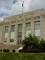
South Liberty Courthouse Square Historic District
The South Liberty Courthouse Square Historic District centers around the historic courthouse in Liberty. Courthouses are very important buildings where laws are made and justice is served. This district shows the historic buildings that surround this important civic center.
Archeological Sites and Cemeteries
Some historic places are not buildings but important sites where we can learn about very old history or remember people from the past.
Nebo Hill Archeological Site
The Nebo Hill Archeological Site near Liberty is a place where scientists study ancient human history. Archeologists dig here to find tools, pottery, and other clues that tell us about the lives of people who lived thousands of years ago.
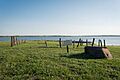
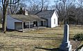
Aker Cemetery
The Aker Cemetery near Smithville is a historic burial ground. Cemeteries are important places to remember people from the past and learn about the history of families and communities.
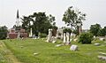
Mt. Memorial Cemetery
In Liberty, Mt. Memorial Cemetery is another historic cemetery. It provides a quiet place to reflect on the past and the lives of those who came before us.
National Historic Landmark
One special place in Clay County is a National Historic Landmark. This means it's considered one of the most important historic places in the entire country!
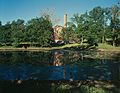
Watkins Mill
Watkins Mill State Park and State Historic Site near Excelsior Springs is a National Historic Landmark. It's a rare example of a 19th-century woolen mill that is still mostly intact. You can see the original machinery and learn how wool was processed into cloth long ago. It also includes the Watkins family home and farm, showing a complete picture of life and industry from that time.
These are just some of the amazing historic places in Clay County, Missouri. Each one has a unique story to tell, helping us connect with the past and understand the rich history of this area.
Images for kids
-
Aker Cemetery
-
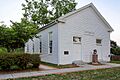
Antioch Christian Church
-
Armour Theatre Building
-

Clay County Savings Association Building
-
Claybrook House
-

Elms Hotel
-

Hall of Waters
-
IOOF Liberty Lodge No. 49
-
James Brothers' House and Farm
-
Jewell Hall
-

Miller Building
-

Missouri City Savings Bank Building and Meeting Hall
-
Mt. Memorial Cemetery
-
Odd Fellows Home District
-
Sears, Roebuck and Company Warehouse Building
-
South Liberty Courthouse Square Historic District
-
Watkins Mill
-
Woodneath
-
Wyman School


.jpg)


