
National Register of Historic Places listings in Dearborn County, Indiana facts for kids

This page lists special places in Dearborn County, Indiana, that are part of the National Register of Historic Places. This register is like a national list of buildings, sites, and objects that are important in American history, architecture, archaeology, engineering, or culture. When a place is on this list, it means it's recognized as valuable and worth protecting for future generations.
In Dearborn County, Indiana, there are 28 different places and areas on this list. One of them is even more special and is called a National Historic Landmark, which means it's super important to the history of the entire country! You can find these places in towns like Aurora and Lawrenceburg, or in the countryside.
Contents
Historic Treasures of Dearborn County
Dearborn County is home to many fascinating historic sites. These places tell stories about the past, from old government buildings to beautiful churches and even ancient Native American sites.
Buildings in Aurora
The town of Aurora has many buildings listed on the National Register. These structures show different styles of architecture and tell about the town's history.
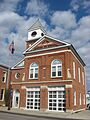
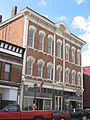
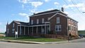
Aurora City Hall
The Aurora City Hall is an important building in Aurora. It's located at 216 3rd Street and 233-237 Main Street. This building has been a key part of the city's government for many years.
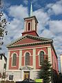
Aurora Churches
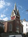
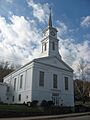
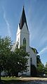
Several churches in Aurora are also on the list. The Aurora Methodist Episcopal Church at 304 3rd Street and the First Evangelical United Church of Christ at 111 5th Street are examples. These churches have beautiful designs and have served their communities for a long time. The First Presbyterian Church at 215 4th Street is another historic religious building.
Aurora Public Library
The Aurora Public Library at 414 2nd Street is a lovely building. It was designed in 1923 in a style called Neo-Renaissance, which means it looks like buildings from the Renaissance period in Europe.
Historic Homes in Aurora
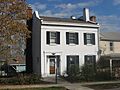
Aurora also has some historic houses. The Lewis Hurlbert, Sr. House at 412 5th Street and the Levi Stevens House at 122 5th Street are examples of homes that show how people lived in the past.
Leive, Parks and Stapp Opera House
The Leive, Parks and Stapp Opera House at 321-325 2nd Street was once a place for entertainment. Imagine people watching plays and performances here many years ago!
Dr. George Sutton Medical Office Building
The George Sutton Medical Office at 315 3rd Street was the office of a doctor named George Sutton. It's interesting to see how medical offices looked in the past.
Lawrenceburg Landmarks
Lawrenceburg, another important town in Dearborn County, also has several significant listings.
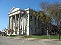
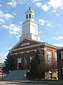
Dearborn County Courthouse
The Dearborn County Courthouse at High and Mary Streets is where many important decisions for the county have been made. It's a grand building that stands as a symbol of local government.
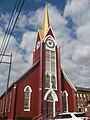
Hamline Chapel United Methodist Church
The Hamline Chapel United Methodist Church at High and Vine Streets is another historic church in Lawrenceburg. Its architecture tells a story of faith and community.
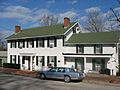
Daniel S. Major House
The Daniel S. Major House at 761 W. Eads Parkway is a historic home that gives us a glimpse into the lives of people from long ago in Lawrenceburg.
Vance-Tousey House
The Vance-Tousey House at 508 W. High Street is another important historic house in Lawrenceburg, showing the architectural styles of its time.
Moores Hill Highlights
Moores Hill also contributes to Dearborn County's historic places.
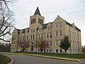
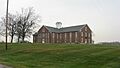
Carnegie Hall of Moores Hill College
The Carnegie Hall of Moores Hill College at 14687 Main Street is a building that was once part of a college. It was likely funded by Andrew Carnegie, who helped build many libraries and educational buildings across the country.
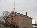
Moores Hill United Methodist Church
The Moores Hill United Methodist Church at 13476 Main Street is a historic church in Moores Hill, important to the town's heritage.
Other Notable Sites in the County
Beyond the towns, Dearborn County has other unique historic locations.
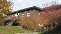
Dearborn County Asylum for the Poor
The Dearborn County Asylum for the Poor at 11636 County Farm Road, northwest of Aurora, is a historic site that tells about how society cared for those in need in the past.
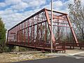
George Street Bridge
The George Street Bridge connects George, Main, and Importing Streets in Aurora. Bridges are important for transportation and can also be historic structures.
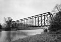
Laughery Creek Bridge
The Laughery Creek Bridge, located south of Aurora, is another historic bridge. It's an interesting example of old engineering and even extends into Ohio County, Indiana.
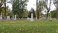
River View Cemetery
The River View Cemetery at 3635 E. Laughery Creek Road, south of Aurora, is a historic burial ground. Cemeteries can be important for understanding local history and art.
St. John's Lutheran Church and School
The St. John's Lutheran Church and School at 7291 State Road 62, southwest of Dillsboro, is a historic complex that includes both a church and a school building.
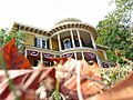
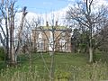
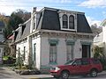
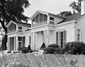
Veraestau
Veraestau is a very important historic property located about 1 mile south of Aurora on State Road 56. It's a beautiful estate with a rich history.
Archaeological Districts
Some listings are not buildings but important archaeological sites.
Jennison Guard Site
The Jennison Guard Site is located between a rail line and the Ohio River, just west of the mouth of the Great Miami River and northeast of Lawrenceburg. This site is important for understanding ancient cultures that lived in the area.
State Line Archeological District
The State Line Archeological District is unique because it crosses the border between Ohio and Indiana, about 2 miles north of the Ohio River. This area holds clues about early human settlements.
Historic Districts
Sometimes, a whole area or neighborhood is considered historic because it has many important buildings together.
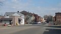
Downtown Aurora Historic District
The Downtown Aurora Historic District includes a large part of downtown Aurora, bounded by Importing, Water, Market, 5th, and Exporting Streets. This area has many buildings that together create a historic feel.
Downtown Lawrenceburg Historic District
Similarly, the Downtown Lawrenceburg Historic District covers a significant part of downtown Lawrenceburg. It's roughly bounded by the former Conrail railroad line and Charlotte, Tate, Williams, and Elm Streets. This district shows the historic layout and buildings of the city center.
Images for kids
-
Aurora City Hall
-
Aurora Methodist Episcopal Church
-
Aurora Public Library
-
Carnegie Hall of Moores Hill College
-
Dearborn County Asylum for the Poor
-
Dearborn County Courthouse
-
Downtown Aurora Historic District
-
Downtown Lawrenceburg Historic District
-
First Evangelical United Church of Christ
-
First Presbyterian Church
-
George Street Bridge
-
Hamline Chapel United Methodist Church
-
Hillforest
-
Lewis Hurlbert, Sr. House
-
Jennison Guard Site
-
Laughery Creek Bridge
-
Leive, Parks and Stapp Opera House
-
Daniel S. Major House
-
Moores Hill United Methodist Church
-
River View Cemetery
-
St. John's Lutheran Church and School
-
Levi Stevens House
-
State Line Archeological District
-
Dr. George Sutton Medical Office Building
-
Vance-Tousey House
-
Veraestau


.jpg)


