
National Register of Historic Places listings in Franklin County, Florida facts for kids

Have you ever wondered about really old and important places in Florida? This article is all about the special historic spots in Franklin County, Florida, that are listed on the National Register of Historic Places. This is a list kept by the United States government to recognize places that are important to our country's history. When a place is on this list, it means it's worth protecting and learning about!
Franklin County has 9 places listed on the National Register. One of them is even more special and is called a National Historic Landmark. This means it's super important to the history of the entire country!
Historic Places in Franklin County
Here are some of the amazing historic places you can find in Franklin County:
Apalachicola Historic District
The Apalachicola Historic District is a large area in the city of Apalachicola. It's filled with many old buildings that show what life was like long ago. This district was added to the National Register on November 21, 1980. It's a great place to walk around and imagine the past!
Cape St. George Light
The Cape St. George Light is a historic lighthouse located on St. George Island. Lighthouses were super important for guiding ships safely to shore. This one was added to the National Register on September 10, 1974. It's a tall, beautiful reminder of the sea's history.
Crooked River Lighthouse
Another important lighthouse in Franklin County is the Crooked River Lighthouse. You can find it southwest of Carrabelle. This lighthouse helped sailors navigate the waters near Carrabelle. It joined the National Register on December 1, 1978.
Fort Gadsden Historic Memorial
Fort Gadsden Historic Memorial is a very important historical site located near Sumatra. This fort has a rich history and is even a National Historic Landmark. It was added to the National Register on February 23, 1972. It tells a story of different groups of people who lived and fought in this area long ago.
David G. Raney House
The David G. Raney House is a beautiful old home in Apalachicola. It's located at the corner of Market Street and Avenue F. This house was recognized for its historical value and was added to the National Register on September 22, 1972. It's a great example of old Florida architecture.
Trinity Episcopal Church
The Trinity Episcopal Church is another historic building in Apalachicola. It stands at Avenue D and 6th Street, in a spot called Gorrie Square. This church has been a part of the community for a very long time. It was added to the National Register on June 30, 1972.
Archaeological Sites
Franklin County also has some important archaeological sites. These are places where scientists study old human history by looking at things left behind, like tools or old settlements. These sites are often kept secret to protect them.
Pierce Site
The Pierce Site is an archaeological site near Apalachicola. It was added to the National Register on January 11, 1974.
Porter's Bar Site
The Porter's Bar Site is another archaeological site, located near Eastpoint. It became part of the National Register on January 23, 1975.
Yent Mound
The Yent Mound is an archaeological mound located near St. Teresa. Mounds like this were often built by ancient people for special purposes. It was added to the National Register on May 24, 1973.
Images for kids
-
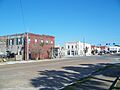
A street view of the Apalachicola Historic District.
-
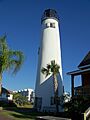
The Cape St. George Light standing tall on St. George Island.
-
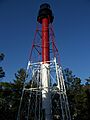
The Crooked River Lighthouse near Carrabelle.
-
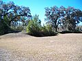
A view of the Fort Gadsden Historic Memorial site.
-
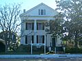
The historic David G. Raney House in Apalachicola.
-

The Trinity Episcopal Church in Apalachicola.


