
National Register of Historic Places listings in Hughes County, South Dakota facts for kids

Hughes County, South Dakota, is home to many amazing places that are listed on the National Register of Historic Places. This special list includes buildings, sites, and objects that are important to American history, architecture, archaeology, engineering, or culture. When a place is on this list, it means it's recognized for its historical value and efforts are made to protect it.
In Hughes County, there are 43 places on the National Register. One of them is even a National Historic Landmark, which is a super important site! Let's explore some of these cool historic spots.
Contents
Ancient Sites and Early History
Hughes County has some really old sites that tell us about the people who lived here long ago. These places are often archaeological sites, meaning they contain clues about past human activity.
Mysterious Petroforms
Some sites are part of the "Petroforms of South Dakota." Petroforms are designs or shapes made on the ground using rocks. They were created by Native American people for different purposes, like ceremonies or marking important places.
- Archeological Site 39HU66 near Canning
- Archeological Site 39HU189 near Macs Corner
- Archeological Site 39HU201 near Pierre
The Arzberger Site
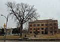
The Arzberger Site is a very important archaeological site near Pierre. It's so special that it's a National Historic Landmark! This site helps us learn about ancient villages and how people lived hundreds of years ago in this area.
Other Important Archeological Areas
- Cedar Islands Archeological District near Pierre
- Fort George Creek Archeological District near Pierre
- McClure Site (39HU7) near Pierre
- Medicine Creek Archeological District near Lower Brule (this one also goes into Lyman County)
- Old Fort Sully Site (39HU52) near Pierre
These districts and sites give us a peek into the past, showing us how early communities were organized and what their daily lives were like.
Historic Homes and Buildings in Pierre
Many of Hughes County's historic listings are beautiful old homes and important buildings in the city of Pierre, the state capital.
Grand Old Houses
- Dr. William and Elizabeth Blackburn House (1997)
- Brink-Wegner House (1978)
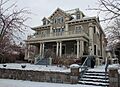
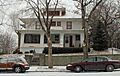
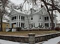
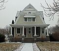
- Crawford-Pettyjohn House (1977)
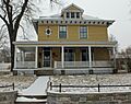
- Farr House (1980)
- I. W. Goodner House (1995)
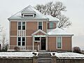
- Peter Hansen House (1999) - This house is special because it's a "Lustron House," a type of prefabricated enamel steel home built after World War II.
- John E. and Ruth Hipple House (2001)
- Horner-Hyde House (1988)
- Hyde Buildings (1983) - A group of buildings that show how Pierre grew.
- Karcher-Sahr House (1977)
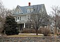
- Henry M. McDonald House (1989)
- George McMillen House (1983)
- Judge C. D. Meade House (1977)
- Pringle House (2012)
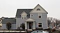
- Rowe House (2001)
- Kenneth R. Scurr House (1993)
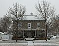
- Stephens-Lucas House (1977)
These homes show different styles of architecture from when Pierre was first settled and grew into a city.
Important Public and Commercial Buildings
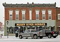
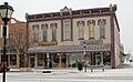
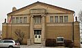
- Central Block (1989) - A historic commercial building.
- Hilger Block (2006) - Another important commercial building.
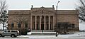
- Hughes County Courthouse (1993) - The place where local government business happens.
- Karcher Block (1993) - A historic building in downtown Pierre.
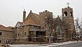
- Methodist Episcopal Church (1997) - A beautiful old church building.
- Pierre Masonic Lodge (2009) - A building used by the Masonic Lodge.
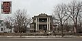
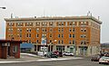
- St. Charles Hotel (1980) - A historic hotel that once welcomed travelers.
- Soldiers & Sailors World War Memorial (1983) - A monument honoring those who served in wars.
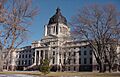
- South Dakota State Capitol (1976) - The main building for South Dakota's government. It's a very grand and important landmark.
These buildings tell the story of Pierre's development as a city and the capital of South Dakota.
Other Notable Historic Places
Hughes County also has other unique historic listings outside of Pierre.
Mentor Graham House
The Mentor Graham House (1976) is located in Blunt. Mentor Graham was a teacher who helped Abraham Lincoln improve his grammar and math skills. This house is a reminder of his life and connection to an important historical figure.
Harrold School
The Harrold School (2003) in Harrold is part of a group of historic schools in South Dakota. It represents the history of education in the state.
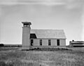
Oahe Chapel
The Oahe Chapel (1980) is a charming little chapel located northwest of Pierre. It's a beautiful and peaceful historic spot.
Chicago and North Western Railroad Bridge
The Chicago and North Western Railroad Bridge (1998) crosses the Missouri River near Pierre. This bridge is a great example of early railroad engineering and played a big part in connecting different parts of the state.
Historic Districts
Some listings are not just single buildings but entire areas called "historic districts." These districts have many buildings that together create a historic feel.
- Oahe Addition Historic District (2000) in Pierre
- Pierre Hill Residential Historic District (1998) in Pierre
These districts help preserve the look and feel of old neighborhoods.
Images for kids
-
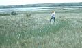
The Arzberger Site, a National Historic Landmark.
-
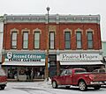
The Central Block building in Pierre.
-
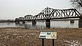
The historic railroad bridge over the Missouri River.
-
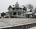
The Crawford-Pettyjohn House.
-
The Farr House.
-
The I. W. Goodner House.
-
The Peter Hansen House, a unique Lustron home.
-
The Hilger Block.
-
The John E. and Ruth Hipple House.
-
The Horner-Hyde House.
-
The Hughes County Courthouse.
-
The Karcher Block.
-
The Karcher-Sahr House.
-
The George McMillen House.
-
The Judge C. D. Meade House.
-
The Methodist Episcopal Church in Pierre.
-
The historic Oahe Chapel.
-
A street view from the Pierre Hill Residential Historic District.
-
The Pierre Masonic Lodge.
-
The Rowe House.
-
The St. Charles Hotel.
-
The Soldiers & Sailors World War Memorial.
-
The South Dakota State Capitol building.
-
The Stephens-Lucas House.


