
National Register of Historic Places listings in Jefferson County, Ohio facts for kids

Imagine a special list that keeps track of important buildings, places, and areas across the United States. This list is called the National Register of Historic Places. It helps protect and celebrate places that tell us about America's past. In Jefferson County, Ohio, there are many such cool spots! This article will tell you about some of these amazing places that have been saved because they are so important to history.
There are 25 different places and areas in Jefferson County that are on this special list. Two of them are even more important and are called National Historic Landmarks. A couple of other places used to be on the list but have since been removed.
Cool Historic Places in Jefferson County
What is the National Register?
The National Register of Historic Places is like a hall of fame for buildings, sites, and objects that have played a big part in American history, architecture, archaeology, engineering, or culture. When a place is added to this list, it means it's recognized as important and efforts are made to preserve it for future generations. It's a way to make sure we don't forget the stories these places can tell us.
Exploring Jefferson County's Historic Sites
Jefferson County is full of interesting places that have been recognized for their historical value. Let's explore some of them!
Schools and Learning Centers
Several old schools in Jefferson County are on the National Register, showing how important education has always been.
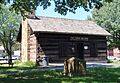
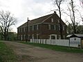
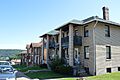
- The Bantam Ridge School was listed in 1981. It's located southwest of Wintersville.
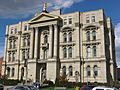
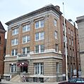
- The Carnegie Library of Steubenville was built with money from famous businessman Andrew Carnegie. It became a historic place in 1992 and is located on South 4th Street in Steubenville, Ohio.
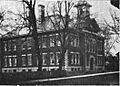
- In Mingo Junction, Ohio, both the Central High School and the Central Public School are recognized. They were added to the list in 1987.
- The Independent School District No. 2 Building in Island Creek Township, north of Steubenville, was listed in 1986. These old school buildings remind us of how students learned many years ago.
Important Buildings and Churches
Many other buildings, from homes to churches, have also made the list.
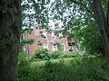
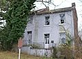
- The Ann E. Lewis Bernhard House in Adena, Ohio, is a historic home listed in 2005.
- The Federal Land Office in Steubenville, listed in 1973, was once a place where people could buy land from the government. It has since been moved to the grounds of Fort Steuben.
- The First Methodist Episcopal-Holy Trinity Greek Orthodox Church in Steubenville, listed in 2006, shows the rich history of different faiths in the area.
- The Friends Meetinghouse near Ohio State Route 150 in Mount Pleasant, Ohio, was listed in 1970. It's a place of worship for the Religious Society of Friends, also known as Quakers.
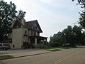
- The Hamilton-Ickes House, north of Adena, is another historic home, added in 1980.
- The Benjamin Lundy House in Mount Pleasant is a very special place, listed as a National Historic Landmark in 1974. Benjamin Lundy was an important person who worked to end slavery.
- The Steubenville YMCA Building, listed in 1982, was a community center for young people.
- The Stringer Stone House in Rayland, Ohio, is an old stone house that became a historic site in 1974.
Historic Districts and Neighborhoods
Sometimes, it's not just one building but a whole area that is historically important. These are called historic districts.
- The Commercial Street Historic District in Mingo Junction was listed in 1987. It includes a section of Commercial Street.
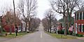
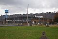
- The Mount Pleasant Historic District in Mount Pleasant is a large area that was listed in 1974. It's even a National Historic Landmark District, meaning it's super important!
- The North End Neighborhood Historic District in Steubenville, listed in 1991, covers a part of North 4th Street.
- The North Hill Historic District in Mingo Junction, listed in 1987, is another neighborhood recognized for its history.
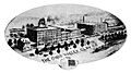
- The Steubenville Commercial Historic District, listed in 1986, includes many important business buildings in downtown Steubenville.
Ancient Mounds and Landmarks
Jefferson County also has ancient sites that tell us about people who lived here long, long ago.
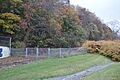
- The Hodgen's Cemetery Mound in Tiltonsville, Ohio, listed in 1975, is an ancient earth mound found within a cemetery.
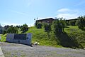
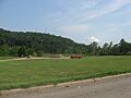
- The Speedway Mound in Warren Township, listed in 1975, is another ancient mound located near an old speedway. These mounds were often built by Native American cultures.
Other Unique Landmarks
- The Market Street Section, Retaining Wall and Water Trough in Steubenville, listed in 1992, is a unique piece of old city infrastructure.
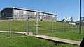
- The Steubenville Pottery Company Buildings in Island Creek Township, listed in 1995, are remnants of a once-important pottery industry.
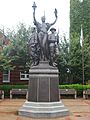
- The Toronto World War I Monument in Toronto, Ohio, listed in 2004, honors those who served in World War I.
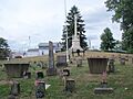
- The Union Cemetery-Beatty Park in Steubenville, listed in 1987, is a historic cemetery and park area.
Places That Were Once Listed
Sometimes, a place might be removed from the National Register. This can happen if the building is changed too much, or if it is torn down.
- The Ohio Valley Clay Company in Steubenville was listed in 1979 but removed in 1995.
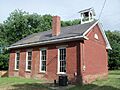
- The Smithfield School in Smithfield, Ohio, was listed in 1981 but removed in 1983.
Images for kids
-
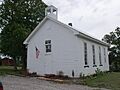
Bantam Ridge School
-
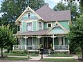
Ann E. Lewis Bernhard House
-
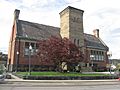
Carnegie Library of Steubenville
-
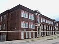
Central High School
-
Central Public School
-
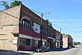
Commercial Street Historic District
-
Federal Land Office
-
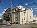
Holy Trinity Greek Orthodox Church
-
Friends Meetinghouse
-
Hamilton-Ickes House
-
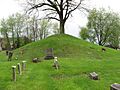
Hodgen's Cemetery Mound
-
Independent School District No. 2 Building
-
Benjamin Lundy House
-
Market Street Section, Retaining Wall and Water Trough
-
Mount Pleasant Historic District
-
North End Neighborhood Historic District
-
North Hill Historic District
-
Speedway Mound
-
Steubenville Commercial Historic District
-
Steubenville Pottery Company Buildings
-
Steubenville YMCA Building
-
Stringer Stone House
-
Toronto World War I Monument
-
Union Cemetery-Beatty Park
-
Ohio Valley Clay Company (former listing)
-
Smithfield School (former listing)


_2012-07-13.JPG)


