
National Register of Historic Places listings in Knox County, Indiana facts for kids

This page lists amazing places in Knox County, Indiana that are part of the National Register of Historic Places. This special list includes buildings, areas, and objects that are important to history. Think of it like a Hall of Fame for historic sites across the United States.
In Knox County, there are 21 places on this list. One of them is even a National Historic Landmark, which means it's super important to the whole country! You can find these special spots in towns like Vincennes or in the countryside, often called a township. Some places might even be in more than one area!
Contents
What is the National Register of Historic Places?
The National Register of Historic Places (NRHP) is the official list of places in the United States that are worth saving. These places could be buildings, structures, objects, or even entire neighborhoods. They are chosen because they have a special connection to history, architecture, archaeology, engineering, or culture. When a place is on this list, it helps protect it and makes people more aware of its importance.
Historic Places in Knox County
Knox County has many cool places that are part of the National Register. Let's explore some of them!
Old Bridges and Mines
- County Bridge No. 45: This old bridge crosses the White River northeast of Wheatland. It was added to the list in 2006. It's a great example of old bridge building!
- Enoco Coal Mine: Located south of Bruceville, this former coal mine was listed in 2010. It reminds us of the history of mining in Indiana.
Important Historical Sites
- Fort Knox II Site: About three miles north of downtown Vincennes, this site was once a fort! It was added to the list in 1982 and is an important part of early American history.
- George Rogers Clark National Historical Park: Found in Vincennes, this park honors George Rogers Clark, a hero of the American Revolutionary War. It became a National Historic Landmark in 1966. You can visit a huge memorial there!
- William Henry Harrison Home (Grouseland): This house in Vincennes was the home of William Henry Harrison, who later became a U.S. President. It's a very important historical site, listed in 1966.
- Territorial Capitol of Former Indiana Territory: Also in Vincennes, this building was once the capital of the Indiana Territory. It's a key place for understanding how Indiana became a state. It was listed in 1973.
Parks and Buildings in Vincennes
Vincennes has many historic spots!
- Gregg Park: This park on Washington Avenue was added to the list in 2013. It's a lovely green space with historical value.
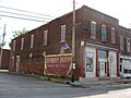
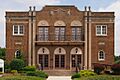
- Hack and Simon Office Building: This office building on North 3rd Street in Vincennes was listed in 2003. It shows us what old business buildings looked like.
- Kimmell Park: Another park in Vincennes, located on Oliphant Drive, was listed in 2013. It's a great place to enjoy nature with a historical background.
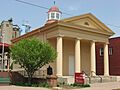
- Old Cathedral Complex: This includes the St. Francis Xavier Cathedral and its library on Church Street. It's a beautiful and historic church that was listed in 1976.
- Old State Bank: Located on North 2nd Street, this old bank building was listed in 1974. It's a cool example of early bank architecture.
- Vincennes Fortnightly Club: This club building on North 6th Street was listed in 2000. It's a historic spot where people gathered for social events.
- Vincennes Historic District: This is a whole area in Vincennes that is considered historic! It was listed in 1974 and includes many important buildings and streets.
Other Interesting Places
- Kixmiller's Store: This old store at Freelandville was listed in 1978. It gives us a peek into how people shopped long ago.
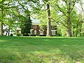
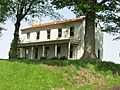
- Mont Clair: This historic home near Vincennes was added to the list in 2016.
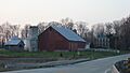
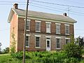
- Andrew Nicholson Farmstead: Located northwest of Wheatland, this farmstead was listed in 2005. It shows what old farms in the area were like.
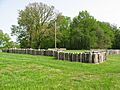
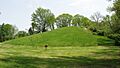
- Pyramid Mound (12k14): Also known as "Lower Sugarloaf Mound," this ancient mound southeast of Vincennes was listed in 1975. It's a fascinating archaeological site!
- Shadowwood: East of Vincennes, this historic property was listed in 2001.
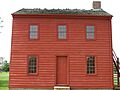
- Alfred Simonson House: This house in Edwardsport was added to the list in 2009.
Former Listings
Sometimes, a place might be removed from the National Register if it's no longer there or has changed too much. Here are two places that were once on the list but are not anymore:
- Ebner-Free House: This house in Vincennes was listed in 1985 but was removed in 1999.
- Rose Hill Farmstead: This farmstead east of Vincennes was listed in 1995 but was removed in 2012.
Images for kids
-
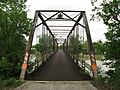
County Bridge No. 45
-
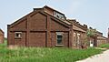
Buildings at the Enoco Coal Mine
-
Palisades at Fort Knox II
-
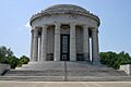
George Rogers Clark Memorial
-
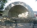
Bandshell in Gregg Park
-
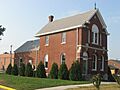
Hack and Simon Office Building
-
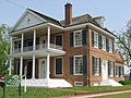
Grouseland, the William Henry Harrison Home
-
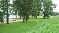
Kimmell Park
-
Kixmiller's Store
-
Andrew Nicholson Farmstead
-
Old Cathedral Complex
-
Old State Bank
-
Pyramid Mound
-
Shadowwood
-
Alfred Simonson House
-
Indiana Territorial Capitol
-
Vincennes Fortnightly Club
-
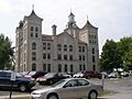
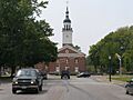
Knox County Courthouse, part of the Vincennes Historic District
-
Rose Hill Farmstead (former listing)


