
National Register of Historic Places listings in Labette County, Kansas facts for kids

This article is about the cool and important places in Labette County, Kansas that are listed on the National Register of Historic Places. This special list helps protect buildings, areas, and even old ruins that are important to the history of the United States.
In Labette County, there are 13 different places on this list. One place was on the list but has since been removed. You can even see where some of these places are on a map if their exact location details are shared!
Contents
What is the National Register of Historic Places?
The National Register of Historic Places, often called the NRHP, is the official list of places in the U.S. that are worth saving because of their history, architecture, or even what they tell us about people who lived long ago. It's like a hall of fame for historic sites! When a place is added to this list, it means it's recognized as special and important to our country's story.
Why are places added to the list?
Places get on the NRHP for many reasons. Maybe a famous person lived there, or an important event happened there. Sometimes, buildings are added because they show a special style of architecture, or they were built in a unique way. Even old archaeological sites, where scientists find clues about ancient cultures, can be listed. The goal is to make sure these places are preserved for future generations to learn from and enjoy.
Historic Places in Labette County
Labette County has a variety of interesting places on the National Register. These include old libraries, banks, bridges, and even ancient sites where people lived thousands of years ago.
Libraries and Public Buildings
Several buildings in Labette County are recognized for their history, especially libraries.
Carnegie Libraries
Two libraries in Labette County were built with money from Andrew Carnegie, a very rich businessman who believed in the power of reading and education. He helped build thousands of libraries across the world!
- The Carnegie Library in Parsons (at 17th and Broadway) was added to the list in 1976. It's a beautiful old building that served the community for many years.
- The Oswego Public Carnegie Library in Oswego (at 704 4th St.) was listed in 1987. This library also shows Carnegie's dedication to public education.

Other Notable Buildings
- The First State Bank in Edna (at the corner of Delaware and Main Sts.) was added in 1982. This building tells us about the history of banking and business in the area.
- The Parsonian Hotel in Parsons (at 1725 Broadway Ave.) was listed more recently in 2015. Hotels like this were once very important gathering places in towns.
- The Parsons Katy Hospital (at 400 Katy Ave.) was added in 2008. Hospitals are key parts of a community's history, showing how healthcare has changed over time.
- The US Post Office-Oswego (at 819 4th St.) became a historic site in 1989. Post offices were central to communication and community life.
Historic Bridges
Labette County also has some historic bridges on the list, showing how people traveled and transported goods long ago.
- The Labette Creek Tributary Bridge is located west of Parsons, off U.S. Route 160. It was listed in 1985.
- The Parsons Filled Arch Bridge is east and south of Parsons, also off U.S. Route 160. It was also added in 1985.
- The Pumpkin Creek Tributary Bridge is west of Mound Valley. It joined the list in 1985.
Ancient Sites and Parks
Some of the oldest historic places in Labette County are not buildings at all, but archaeological sites! These are places where scientists study the remains of ancient cultures.
- The Big Hill Archeological District near Dennis was listed in 1977. This area holds clues about people who lived there thousands of years ago.
- The Harmon Site and Harmon Site No. 2 (14LT323) near Chetopa were added in 1983 and 1984. These sites are important for understanding the early history of humans in Kansas.
- Riverside Park in Oswego (on N. Oregon St.) was listed in 2012. This park is special because it was part of projects from the "New Deal" era, which helped people find jobs during the Great Depression.
Former Listings
Sometimes, a place that was once on the National Register of Historic Places might be removed. This usually happens if the building is destroyed or changed so much that it no longer has its historic importance.
- The East Side School in Oswego (on Iowa St.) was listed in 2002 but was removed from the list in 2010.
Images for kids
-
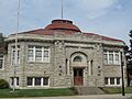
The former Carnegie Library building in Parsons, Kansas.
-
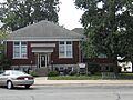
The public library in Oswego, Kansas, also funded by Andrew Carnegie.

