
National Register of Historic Places listings in Mesa County, Colorado facts for kids

Welcome to Mesa County, Colorado! This area is home to many amazing places that are super important because of their history or special design. These places are listed on something called the National Register of Historic Places. It's like a national scrapbook of cool old buildings, parks, and other spots that tell a story about the past.
In Mesa County, there are 35 places on this special list. Each one helps us learn more about how people lived, worked, and built things long ago. Some of these places are still around today, while a couple of others were once on the list but have since been removed. Let's explore some of these fascinating historic sites!
Contents
Historic Buildings and Homes
Many buildings in Mesa County have a rich history. They show us how people lived and worked in the past.
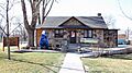
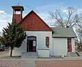
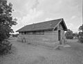
Clifton Community Center and Church
The Clifton Community Center and Church is a special building in Clifton. It was added to the list in 1982. This place has been a central spot for people in the community for a long time. It served as both a place for gatherings and a church.
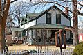
Herbert and Edith Crissey House
In Palisade, you can find the Herbert and Edith Crissey House. This home was listed in 2003. It's a great example of the kind of houses people built in the early 1900s. It shows us how families lived and what their homes looked like back then.
De Beque House
The De Beque House, located in De Beque, joined the National Register in 1995. This house is a significant part of the town's history. It helps us understand the early days of De Beque and the people who settled there.
Hotel St. Regis
In Grand Junction, the Hotel St. Regis is a historic landmark. It was added to the list in 1992. This hotel was once a busy place where travelers and locals stayed. It shows the style and grandeur of hotels from a past era.
Handy Chapel
Also in Grand Junction is Handy Chapel, listed in 1994. This chapel holds a special place in the community's heart. It has served as a spiritual and gathering place for many years, reflecting the history of its neighborhood.
Kettle-Jens House
The Kettle-Jens House in Clifton became a historic site in 1983. This house is another example of the unique architecture and family life from Mesa County's past.
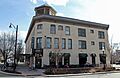
Margery Building
The Margery Building in Grand Junction was listed in 1993. This building is important for its design and its role in the city's business history. It shows how downtown areas developed over time.
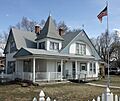
Harry and Lilly Phillips House
In Fruita, the Harry and Lilly Phillips House was added in 1997. This home tells a story about the families who helped build Fruita. It gives us a peek into their daily lives.
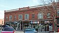
Stranges Grocery
Stranges Grocery in Grand Junction joined the list in 2013. This old grocery store reminds us of a time when local shops were the heart of a neighborhood. It shows how people bought their food and goods.
U.S. Post Office (Grand Junction)
The U.S. Post Office in Grand Junction, listed in 1980, is a grand building. It served as a vital communication hub for the city. Its architecture often reflects the importance of government services.
Historic Schools and Community Places
These places show how communities came together for education and social events.
Coates Creek Schoolhouse
The Coates Creek Schoolhouse, located west of Glade Park, was listed in 1993. This old schoolhouse reminds us of a time when small, one-room schools were common. It shows how children learned in rural areas.
Fruita Museum
The Fruita Museum in Fruita was added to the list in 1996. Museums are important because they preserve history. This building helps tell the story of Fruita and its people.
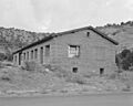
IOOF Hall (De Beque)
The IOOF Hall in De Beque became a historic site in 1993. IOOF stands for "Independent Order of Odd Fellows," a fraternal organization. These halls were often important social centers in small towns.
Loma Community Hall
The Loma Community Hall in Loma was listed in 1995. Community halls like this were places where people gathered for meetings, dances, and other events. They were the heart of social life.
Pipe Line School
The Pipe Line School near Glade Park was added in 1999. Like the Coates Creek Schoolhouse, it represents the history of education in the more remote parts of Mesa County.
Bridges and Infrastructure
Bridges and other structures are important because they show how people traveled and managed resources.
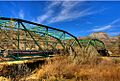
Colorado River Bridge (De Beque)
The Colorado River Bridge near De Beque was listed in 2002. Bridges are key parts of transportation. This one helped people cross the Colorado River, connecting communities.
Fruita Bridge
The Fruita Bridge, crossing the Colorado River in Fruita, was added in 1985. This bridge is another example of important early engineering that made travel easier in the region.
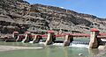
Grand Valley Diversion Dam
The Grand Valley Diversion Dam, northeast of Palisade, joined the list in 1991. Dams like this are crucial for managing water. This one helped bring water to farms and towns in the Grand Valley.
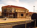
Denver and Rio Grande Western Railroad Depot
The Denver and Rio Grande Western Railroad Depot in Grand Junction was listed in 1992. Train depots were once bustling centers of travel and trade. This one shows the importance of railroads in connecting the West.
Natural and Recreational Sites
Mesa County also has historic sites related to its beautiful natural areas and how people enjoyed them.
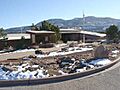
Colorado National Monument Visitor Center Complex
The Colorado National Monument Visitor Center Complex near Fruita was listed in 2003. This complex helps visitors learn about the amazing landscapes of the monument. It shows how parks were designed to welcome people.
Devils Kitchen Picnic Shelter
Inside the Colorado National Monument, the Devils Kitchen Picnic Shelter was added in 1994. This shelter is a historic spot where people could relax and enjoy the outdoors. It reflects early efforts to create public recreational spaces.
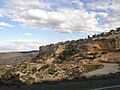
Rim Rock Drive Historic District
Also within the Colorado National Monument, the Rim Rock Drive Historic District was listed in 1994. This scenic road was built to allow people to experience the monument's stunning views. It's a masterpiece of road engineering in a challenging landscape.
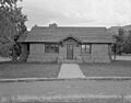
Saddlehorn Caretaker's House and Garage
The Saddlehorn Caretaker's House and Garage, located in the Colorado National Monument, was listed in 1994. This building was home to the people who looked after the park. It shows the daily life of park rangers.
Saddlehorn Comfort Station
The Saddlehorn Comfort Station, also in the Colorado National Monument, was added in 1994. Even restrooms can be historic! This one shows the design and facilities provided for early park visitors.
Saddlehorn Utility Area Historic District
The Saddlehorn Utility Area Historic District in the Colorado National Monument was listed in 1994. This area includes buildings and structures needed to keep the park running, like warehouses. It highlights the behind-the-scenes work of park management.
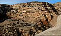
Serpents Trail
The Serpents Trail, found in the Colorado National Monument, was added in 1994. This winding trail was built to help people explore the monument's rugged terrain. It's a historic path that offers incredible views.
Land's End Observatory
The Land's End Observatory near Whitewater was listed in 1997. Observatories are places for looking at the stars and the landscape. This one offers amazing views and has its own unique history.
Other Interesting Sites
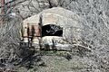
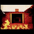
Convicts' Bread Oven
West of Molina, you can find the Convicts' Bread Oven, listed in 1974. This oven was used by prisoners who worked on building roads in the area. It's a unique reminder of how labor was organized in the past.
Cross Land and Fruit Company Orchards and Ranch
Northeast of Grand Junction, the Cross Land and Fruit Company Orchards and Ranch was added in 1980. This site shows the history of farming and fruit growing in Mesa County, which was a very important industry.
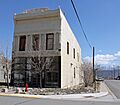
Department of Energy Grand Junction Office
The Department of Energy Grand Junction Office was listed in 2016. This building played a role in important national energy projects. It reflects the area's connection to scientific and government work.
Former Listings
Sometimes, a place is removed from the National Register. This can happen if it is damaged or changed too much.
Black Bridge (Grand Junction)
The Black Bridge in Grand Junction was once on the list, added in 1985. However, it was removed in 1994 because it was damaged by flooding.
Fifth Street Bridge (Grand Junction)
The Fifth Street Bridge in Grand Junction was also listed in 1985 but removed in 1994. This bridge was replaced in 1989, meaning the original historic structure was no longer there.
Images for kids
-

Clifton Community Center and Church
-
Colorado National Monument Visitor Center
-
Colorado River Bridge
-
Convicts' Bread Oven
-

Herbert and Edith Crissey House
-

Cross Land and Fruit Company Orchards and Ranch
-
De Beque House
-
Denver and Rio Grande Western Railroad Depot
-
Devils Kitchen Picnic Shelter
-

Fruita Bridge
-
Fruita Museum
-
Grand Valley Diversion Dam
-
Handy Chapel
-
Hotel St. Regis
-
IOOF Hall
-
Kettle-Jens House
-

Land's End Observatory
-
Margery Building
-
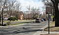
North Seventh Street Historic Residential District
-

Harry and Lilly Phillips House
-
Rim Rock Drive
-
Saddlehorn Caretaker's House and Garage
-
Saddlehorn Comfort Station
-
Saddlehorn Utility Area
-
Serpents Trail
-

U.S. Post Office in Grand Junction
-

Black Bridge (former listing)
-

Fifth Street Bridge (former listing)


.JPG)
.JPG)


.JPG)
