
National Register of Historic Places listings in Morton County, Kansas facts for kids

Have you ever wondered about the special places in your town or county that tell a story from the past? In Morton County, Kansas, there are seven amazing spots listed on the National Register of Historic Places. This is like a special list kept by the United States government that recognizes important buildings, areas, or objects that have played a big part in history. When a place is on this list, it means it's worth protecting and remembering for future generations.
These historic places in Morton County help us learn about how people lived, worked, and traveled long ago. You can even find some of these places on a map using their exact location!
Contents
Exploring Morton County's Historic Treasures
Morton County is home to several unique places that are officially recognized for their historical importance. These sites help us connect with the past and understand the stories of the people who came before us.
The Morton County WPA Bridge
One of the special places is the Morton County WPA Bridge. This bridge was built a long time ago, in 1986, by a program called the Works Progress Administration (WPA). The WPA was a government program during the Great Depression, which was a time when many people didn't have jobs. The WPA hired people to build important things like roads, parks, and bridges. This bridge is located about 6 miles west and 4 miles north of Richfield. It's a reminder of how people worked together to build useful structures during a tough time in history.
The Santa Fe Trail: A Historic Journey
Many of Morton County's historic sites are connected to the famous Santa Fe Trail. This trail was a very important route in the 1800s. It was used by traders, settlers, and soldiers traveling between Missouri and Santa Fe, which was then part of Mexico. Imagine pioneers traveling across the plains, facing challenges, and discovering new lands!
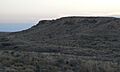
Point of Rocks — Middle Spring Historic District
One significant part of the Santa Fe Trail in Morton County is the Point of Rocks — Middle Spring Santa Fe Trail Historic District. This area was a crucial stop for travelers on the trail. "Point of Rocks" was a well-known landmark, a tall rock formation that helped people find their way. "Middle Spring" was a vital water source in the dry landscape. This district is located about 2.5 miles south of K-51 and 2 miles west of K-27, near Elkhart. It was added to the historic register in 2013.
Santa Fe Trail Segments in Cimarron National Grassland
Several sections of the Santa Fe Trail that run through the Cimarron National Grassland are also listed as historic. The Cimarron National Grassland is a large area of protected land. These segments show us the actual paths that wagons and travelers took many years ago.
- Segment 1: This part of the trail is about 2 miles south of K-51 right at the border between Colorado and Kansas. It was listed in 2013.
- Segment 2: Another section is about 1.66 miles south of K-51 and 1 mile east of County Road 2, also near Elkhart. It was also listed in 2013.
- Segment 3: This segment follows FSR-600, on both the east and west sides of K-27. It's a great example of how the trail crossed different landscapes. This part was listed in 2013.
- Segment 4: You can find this section about 2.5 miles east of K-27, north of FSR-600. It was also added to the register in 2013.
- Segment 5: The final segment is about 7 miles north of US-56 along County Road 16, near Wilburton. This part of the trail was also listed in 2013.
These different segments of the Santa Fe Trail are important because they preserve the actual path of history. They remind us of the challenging journeys people made to explore and settle the American West.
Images for kids
-

The Morton County WPA Bridge, built during the Great Depression.
-
Point of Rocks, a famous landmark on the Santa Fe Trail.
-
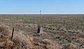
A marker for the Santa Fe Trail near the Kansas-Colorado state line.
-
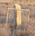
A limestone marker showing the path of the Santa Fe Trail.
-
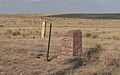
Markers indicating the Santa Fe Trail's route.

_at_sundown_2.JPG)


