
National Register of Historic Places listings in North Cascades National Park facts for kids
North Cascades National Park is a truly amazing place in Washington, known for its tall, rugged mountains, deep forests, and beautiful lakes. But did you know it's also home to many important historical sites? These places tell stories about the people who explored, lived, and worked in this wild area long ago.
This article will introduce you to some of these special spots that are listed on the National Register of Historic Places. Think of this register as a national list of buildings, places, and objects that are important to American history. When a place is on this list, it means it's recognized for its historical value and efforts are made to protect it. There are 16 such places within North Cascades National Park, each with its own unique story!
Contents
Exploring History in North Cascades National Park
North Cascades National Park isn't just about stunning nature; it's also a treasure chest of history. Many of the historic places here are old buildings or structures that helped people manage the park, protect it from fires, or even explore for valuable minerals. These sites give us a peek into what life was like for early rangers, miners, and explorers in this challenging mountain environment.
What is the National Register of Historic Places?
The National Register of Historic Places is the official list of the nation's historic places worthy of preservation. It's like a special hall of fame for buildings, sites, districts, structures, and objects that are important to American history, architecture, archaeology, engineering, or culture. Being on the Register helps to recognize and protect these places so future generations can learn from them.
Historic Buildings and Structures
Many of the historic sites in North Cascades National Park are buildings that played a key role in the park's early days. These include ranger stations, fire lookouts, and shelters.
Ranger Stations and Cabins
Ranger stations and cabins were vital for park rangers who worked to protect the park, help visitors, and manage the wilderness. They often served as homes and offices in remote areas.
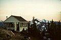
- Backus-Marblemount Ranger Station House No. 1009 and No. 1010: Located near Marblemount in Skagit County, Washington, these houses were built in the early days of park management. They show how rangers lived and worked to establish the park's presence.
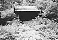
- Bridge Creek Cabin-Ranger Station: Found in the Bridge Creek Campground near Stehekin in Chelan County, Washington, this cabin was an important outpost for rangers deep within the park. It was listed on the Register in 1989.
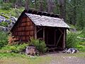
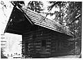
- Gilbert's Cabin: This cabin, located near the Cascade River Road in Skagit County, Washington, was also added to the Register in 1989. It's another example of the simple, sturdy homes built for those working in the park's wilderness.
- Rock Cabin: Situated along the Fisher Creek Trail south of Diablo Lake in Skagit County, Washington, this cabin was listed in 1989. It's a testament to the rugged construction needed to survive in the mountains.
- Sulphide-Frisco Cabin: Found along the Bridge Creek Trail near Stehekin in Chelan County, Washington, this cabin was listed in 1989. It highlights the network of trails and shelters used by early park personnel.
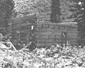
- Swamp-Meadow Cabin (east) and Swamp-Meadow Cabin (west): These two cabins are located along the Thunder Creek Trail south of Diablo Lake in Skagit County, Washington. Listed in 1989, they show how multiple structures were sometimes built close together to support operations in the park.
Fire Lookouts
Fire lookouts are small buildings, often on top of mountains, where people would watch for wildfires. They were crucial for protecting the vast forests of the park.
- Copper Mountain Fire Lookout: Located on Copper Mountain, east of Hannegan Campground near Newhalem in Whatcom County, Washington, this lookout was listed in 1989. It offers incredible views and was essential for spotting fires.
- Sourdough Mountain Lookout: This lookout sits on Sourdough Mountain, northeast of Diablo in Whatcom County, Washington. Listed in 1989, it's another example of the important role these structures played in early fire detection.
Mountain Shelters
Shelters provided a safe place for travelers, rangers, and work crews to rest and find protection from the weather in remote areas.
- Beaver Pass Shelter: This shelter is located at Beaver Pass, west of Ross Lake, near Diablo in Whatcom County, Washington. It was listed in 1989.
- Bridge Creek Shelter: Also in the Bridge Creek Campground near Stehekin in Chelan County, Washington, this shelter was added to the Register in 1989.
- High Bridge Shelter: Found in the High Bridge Campground, off Stehekin Valley Road near Stehekin in Chelan County, Washington, this shelter was listed in 1989.
- Perry Creek Shelter: Located on the Little Beaver Trail, west of Ross Lake, near Hozomeen in Whatcom County, Washington, this shelter was listed in 1989.
Unique Historic Sites
Beyond buildings, some historic sites are unique because of their purpose or what they represent.
Old Mining Sites
- Black Warrior Mine: This mine is located at the end of the Horseshoe Basin Trail, northwest of Stehekin in Chelan County, Washington. It was listed on the Register in 1974, making it one of the earlier sites recognized in the park. It reminds us of the mining history that once took place in these mountains.
International Boundary Markers
- International Boundary US-Canada Monuments: These monuments are found along the border between the United States and Canada, specifically between the eastern boundary of Ross Lake National Recreation Area and the western boundary of North Cascades National Park. Listed in 1989, these markers are important symbols of the boundary between the two countries.
Images for kids
-
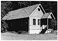
Backus-Marblemount Ranger Station House No. 1009
-
Backus-Marblemount Ranger Station House No. 1010
-
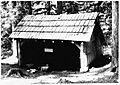
Beaver Pass Shelter
-
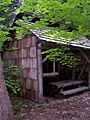
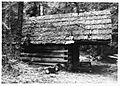
Bridge Creek Shelter
-
Copper Mountain Fire Lookout
-
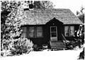
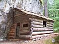
Gilbert's Cabin
-
High Bridge Shelter
-
Perry Creek Shelter
-
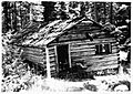
Rock Cabin
-
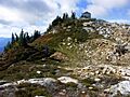
Sourdough Mountain Lookout
-
Sulphide-Frisco Cabin
-
Swamp-Meadow Cabin (east)
-
Swamp-Meadow Cabin (west)


