
Diablo, Washington facts for kids
Quick facts for kids
Diablo, Washington
|
|
|---|---|

Diablo, Washington
|
|

Diablo, Washington
Location in Washington (state)
|
|
| Country | United States |
| State | Washington |
| County | Whatcom |
| Government | |
| • Type | Company town |
| Area | |
| • Total | 69 acre (28 ha) |
| Elevation | 896 ft (273 m) |
| Time zone | UTC-8 (Pacific (PST)) |
| • Summer (DST) | UTC-7 (PDT) |
| ZIP Code |
98283
|
| Area code(s) | 360, 564 |
| GNIS feature ID | 1518740 |
Diablo is a small, unique community in Whatcom County, Washington, United States. It's not a city with its own government, but rather an unincorporated community. Diablo is nestled near the Diablo Dam within the beautiful Ross Lake National Recreation Area, right along the Skagit River.
This community was first created in the late 1920s by Seattle City Light. It was a "company town," meaning the company owned most of the homes and businesses. Its main purpose was to support the building of Diablo Dam. This dam is one of three big dams that make up the Skagit River Hydroelectric Project, which generates electricity from water power.
Today, Seattle City Light still manages Diablo. However, they now work with the National Park Service and the North Cascades Institute. Together, they offer exciting educational programs and fun outdoor activities in the area.
Diablo has two main parts: Hollywood (which used to be called Cedar Bar) and Reflector Bar. A single road connects these two areas. Between them, you'll find the Diablo Dam's powerhouse and an electrical station. Diablo doesn't have its own post office. For mail, it's considered part of Rockport, Washington. You can reach Diablo by driving on Washington State Route 20. It's about 30 miles (48 km) northeast of Rockport.
The name "Diablo" comes from Diablo Canyon. Early explorers and miners gave it this name. It might have been because the canyon was very hard to travel through. Or, it could have been named after a similar place in the American Southwest. Today, Diablo is famous for being close to amazing places like Diablo Lake. It's also known for its many hiking trails, campgrounds, and interesting historical spots.
Contents
Discovering Diablo's History
Before European settlers arrived, the land around Diablo was home to the Kwabatsabsh people. They are now part of the Upper Skagit Indian Tribe. Stories from the Upper Skagit people have helped us learn about past events, like a big flood in 1815.
Reflector Bar is a sandy area by the river. It's where the Skagit River and Stetattle Creek meet. This spot might have been very important to the tribe. The word Stetattle likely means "barrier" or "boundary" in their language. Some believe it marked the edge of the Kwabatsabsh people's land. Others think it referred to a boundary between the real world and a world of spirits.
Early Settlers and the Davis Family
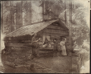
In June 1898, Lucinda Davis and her children started a homestead at Cedar Bar. This was close to where Diablo is today. Back then, getting to this area was very difficult. You could only reach it by a tough and dangerous trail from Newhalem.
The Davis family opened an inn. It served many local miners, forest rangers, and hunters. Their inn was quite modern for such a remote place. It even had electricity and a radio! In 1904, a group of climbers honored the family. They renamed Stetattle Peak to Davis Peak.
Later, the United States Forest Service looked at the Davis family's land claim. They reduced the original claim and planned to use some land for a ranger station. In 1917, the Davis family officially received ownership of their land. That same year, Frank Davis built the first Sourdough Mountain Lookout. It was later rebuilt by the Civilian Conservation Corps (CCC) in 1933. At that time, a team of 18 CCC men lived in Reflector Bar.
.jpg)
In the 1920s, Seattle City Light became interested in using the river's power for electricity. By 1928, they began the process to acquire land for their dam project. The Davis family eventually lost their land and moved away in 1929. City Light later honored the family. They built a copy of their old power station, including the original waterwheel.
Building the Dams: Reflector Bar
-
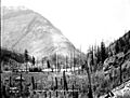
Ranger station at Reflector Bar (1919)
-
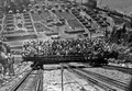
Tourists on the inclined railway, with Reflector Bar in the background (1930)
-
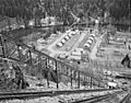
View from the top of the inclined railway (1954)
.jpg)
.jpg)
Reflector Bar was named for a small shelter with a reflector that was built there. It was also the location of a Forest Service ranger station. In 1927, the Forest Service allowed City Light to use the area. A railroad bridge was built over Stetattle Creek in late 1927 or early 1928. This bridge connected Reflector Bar to Newhalem. The train tracks were electric, but a steam engine was used for steep parts.
By 1928, Reflector Bar had many buildings. They were arranged in a U-shape around a central dining hall. There were cottages and larger houses for the dam project's managers. The area even had fun things like a tennis court, a small zoo, and a swimming pool!
After the dam was finished in 1930, many buildings were taken down. The dam's powerhouse still needed to be built. For a while, Reflector Bar housed a huge 300-ton crane. In 1934, a water tower was built, which is still a landmark today. The dining hall became a store, workshop, storage area, and recreation hall.
By the 1970s, most of the buildings were gone. Lawns replaced them, even though there were earlier plans for a wild garden.
Hollywood's Story
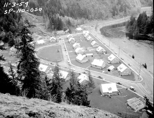
The old Davis ranch area was renamed from Cedar Bar to Hollywood. In the mid-1920s, about 20 small shacks were in Hollywood. The Davis family might have rented these to workers before their land was taken. In 1935, a building was given for a school for eight children. A bigger school was built in 1946 because more people moved in during the building of Ross Dam. That school building is still there today. It's now a dining hall, visitor center, and museum.
Employees complained about the simple buildings and lack of plumbing. So, in 1938, City Light built five new houses and an apartment building. By then, only five of the original 1920s shacks remained. In 1952, plans were made for 36 new buildings. However, the plan was scaled down when it was decided some old buildings could be kept. Only one of the houses built in 1938 survived.
Diablo has experienced floods for a long time, dating back to at least 1815. After a very bad winter of floods in 1950, City Light raised the lower parts of Hollywood. This helped prevent flood damage and prepared the area for the new Gorge Dam being built downstream. During this time, the old 1920s shacks were torn down for new development. The changes and rebuilding in Hollywood in the 1950s created much of the neighborhood you see today. Railroad tracks were removed, bridges were paved, roads were fixed, and 28 new houses were built. New sewer and water systems, sidewalks, and street lights were also added.
Diablo Today

In 1972, City Light decided to make its dams automatic. This meant most residents moved away, and only a few essential workers stayed. The town is still managed by City Light. However, it now provides homes for employees of the National Park Service and the North Cascades Institute. These groups run the nearby North Cascades Environmental Learning Center. City Light and the National Park Service work together to maintain trails in and around Diablo.
From July 29 to October 1, 2023, the Sourdough Fire caused the closure of Diablo. It also closed the North Cascades Highway (State Route 20), recreational areas, and the three dams.
Exploring Diablo's Surroundings
Seattle City Light created the community of Diablo as a company town. Its purpose was to support the building of Diablo Dam and other dams for the Skagit River Hydroelectric Project. Diablo has two main parts: Reflector Bar (upstream) and Hollywood (downstream, also called Cedar Bar). A paved road, which used to be a railway, connects them. Hollywood was mainly for homes. Reflector Bar has maintenance buildings, an inclined railway, a water tower, a helipad, and a few houses. Many buildings in Diablo are now empty. The Diablo Dam powerhouse and substation are located between the two areas. City Light still owns the land in Hollywood. The United States Forest Service manages the land in Reflector Bar.
Diablo is about 38 miles (61 km) east of Concrete, the closest larger town. It's located on Washington State Route 20, also known as the North Cascades Highway. To the east, the closest larger town is Winthrop, about 68 miles (109 km) away.
Mountains, Rivers, and Rocks
.jpg)
Diablo is in the upper Skagit River valley in Whatcom County. This area is part of the North Cascades mountains in northern Washington. The community sits on two flat areas by the river: Reflector Bar to the south and Cedar Bar (Hollywood) to the north. These are some of the only flat, stable places to build in this mountainous region.
Diablo is in the middle of a narrow, 10-mile (16 km) canyon. This canyon was carved by the Skagit River and by ancient glaciers. Long ago, the Skagit River might have flowed north into Canada. But as huge ice sheets grew and shrank, they blocked the river. This forced the river to find new paths to the south, carving deep gorges. The Skagit gorge became so deep that the river kept flowing south even after the ice disappeared.
Diablo is about 896 feet (273 meters) above sea level. This is quite low compared to nearby Diablo Lake, which is a reservoir at 1,201 feet (366 meters). The surrounding Cascade peaks are much higher, some over 7,000 feet (2,134 meters)!

The main type of rock in this area is called the Skagit Gneiss Complex. This is a very strong, metamorphic rock that forms the core of the North Cascades. This tough rock has shaped the valleys and ridges you see. It also creates fine sediments called "glacial flour." These tiny rock particles give Diablo Lake its beautiful turquoise color when they are mixed in the melting glacier water.
Diablo's Weather
The Western Regional Climate Center (WRCC) has been recording weather data at Diablo Dam since 1948. The weather station is located at an elevation of 891 feet (272 meters).
| Climate data for Diablo, Washington (Diablo Dam) 1991–2020, extremes 1914–present | |||||||||||||
|---|---|---|---|---|---|---|---|---|---|---|---|---|---|
| Month | Jan | Feb | Mar | Apr | May | Jun | Jul | Aug | Sep | Oct | Nov | Dec | Year |
| Record high °F (°C) | 62 (17) |
63 (17) |
76 (24) |
90 (32) |
103 (39) |
110 (43) |
106 (41) |
106 (41) |
101 (38) |
87 (31) |
65 (18) |
59 (15) |
110 (43) |
| Mean maximum °F (°C) | 48.4 (9.1) |
52.7 (11.5) |
63.7 (17.6) |
75.9 (24.4) |
86.4 (30.2) |
90.8 (32.7) |
95.6 (35.3) |
94.8 (34.9) |
88.4 (31.3) |
72.7 (22.6) |
55.1 (12.8) |
48.5 (9.2) |
98.3 (36.8) |
| Mean daily maximum °F (°C) | 38.5 (3.6) |
43.2 (6.2) |
49.0 (9.4) |
57.2 (14.0) |
66.1 (18.9) |
70.3 (21.3) |
78.1 (25.6) |
78.8 (26.0) |
71.3 (21.8) |
57.5 (14.2) |
44.7 (7.1) |
38.1 (3.4) |
57.7 (14.3) |
| Daily mean °F (°C) | 34.0 (1.1) |
36.7 (2.6) |
41.1 (5.1) |
47.4 (8.6) |
55.2 (12.9) |
59.8 (15.4) |
65.8 (18.8) |
66.4 (19.1) |
60.1 (15.6) |
49.5 (9.7) |
39.8 (4.3) |
34.2 (1.2) |
49.2 (9.6) |
| Mean daily minimum °F (°C) | 29.5 (−1.4) |
30.3 (−0.9) |
33.1 (0.6) |
37.5 (3.1) |
44.2 (6.8) |
49.4 (9.7) |
53.4 (11.9) |
53.9 (12.2) |
48.9 (9.4) |
41.5 (5.3) |
34.8 (1.6) |
30.2 (−1.0) |
40.6 (4.8) |
| Mean minimum °F (°C) | 17.4 (−8.1) |
21.2 (−6.0) |
25.5 (−3.6) |
30.7 (−0.7) |
35.8 (2.1) |
42.5 (5.8) |
47.3 (8.5) |
47.3 (8.5) |
41.4 (5.2) |
31.8 (−0.1) |
24.4 (−4.2) |
19.1 (−7.2) |
11.2 (−11.6) |
| Record low °F (°C) | −2 (−19) |
0 (−18) |
9 (−13) |
24 (−4) |
28 (−2) |
33 (1) |
38 (3) |
37 (3) |
31 (−1) |
18 (−8) |
5 (−15) |
−2 (−19) |
−2 (−19) |
| Average precipitation inches (mm) | 12.25 (311) |
7.38 (187) |
8.16 (207) |
4.60 (117) |
2.71 (69) |
2.25 (57) |
1.25 (32) |
1.51 (38) |
3.41 (87) |
8.64 (219) |
13.66 (347) |
11.57 (294) |
77.39 (1,965) |
| Average snowfall inches (cm) | 12.2 (31) |
9.9 (25) |
4.2 (11) |
0.3 (0.76) |
0.0 (0.0) |
0.0 (0.0) |
0.0 (0.0) |
0.0 (0.0) |
0.0 (0.0) |
0.0 (0.0) |
3.1 (7.9) |
16.0 (41) |
45.7 (116.66) |
| Average extreme snow depth inches (cm) | 11.0 (28) |
7.7 (20) |
4.1 (10) |
0.1 (0.25) |
0.0 (0.0) |
0.0 (0.0) |
0.0 (0.0) |
0.0 (0.0) |
0.0 (0.0) |
0.0 (0.0) |
1.9 (4.8) |
9.7 (25) |
16.0 (41) |
| Average precipitation days (≥ 0.01 in) | 18.8 | 15.6 | 19.0 | 16.5 | 12.8 | 12.1 | 6.4 | 6.3 | 10.8 | 16.6 | 19.9 | 19.5 | 174.3 |
| Average snowy days (≥ 0.1 in) | 4.4 | 2.6 | 2.0 | 0.1 | 0.0 | 0.0 | 0.0 | 0.0 | 0.0 | 0.0 | 1.3 | 5.1 | 15.5 |
| Source 1: NOAA | |||||||||||||
| Source 2: National Weather Service | |||||||||||||
Fun Things to Do in Diablo
.jpg)
From 1928 until World War II began, City Light offered guided tours of the Skagit River Hydroelectric Project. Visitors would start in Rockport and ride a steam train 23 miles (37 km) to Newhalem. The next day, they would take another train to Diablo. There, they toured the powerhouse and rode an inclined lift to the top of the dam. The tour continued by boat to Ruby Creek before returning to Rockport. By 1941, over 100,000 people had visited the Skagit Project! After the war, shorter tours started again.
Since 1986, Diablo has been home to the North Cascades Environmental Learning Center. This center offers places to stay, fun getaways, tours of Diablo Lake, photography and art classes, and a conference center. The North Cascades Institute runs the center. They work with Seattle City Light to offer tours of the dams and powerhouses.
Diablo is located within the Ross Lake National Recreation Area. This area is part of the North Cascades National Park Service Complex. It offers many trails for hiking, camping grounds, boat launches, and places to fish.
Places with History
Several buildings and sites in and around Diablo are listed on the National Register of Historic Places. This means they are important historical sites!
- Beaver Pass Shelter
- Diablo Hydroelectric Power Plant
- Rock Cabin
- Skagit River and Newhalem Creek Hydroelectric Projects
- Sourdough Mountain Lookout
- Swamp–Meadow Cabin (east)
- Swamp–Meado Cabin (west)
People from Diablo
- Elizabeth W. Jones, a geneticist, lived in Diablo for ten years as a child.
- Jeff Sherman, a founding member of the band Glass, lived in Diablo as a child.
More to See
- Diablo Dam
- Diablo Lake
- Newhalem, Washington
- Skagit River Hydroelectric Project
- Seattle City Light
