Rockport, Washington facts for kids
Quick facts for kids
Rockport, Washington
|
|
|---|---|

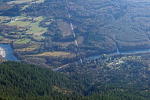
Rockport (bottom right) lies at the junction of Washington State Route 530 (center) with Washington State Route 20 (hidden by trees).
|
|

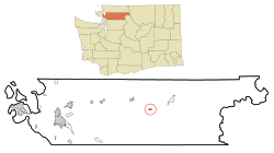
Location of Rockport, Washington
|
|
| Country | United States |
| State | Washington |
| County | Skagit |
| Area | |
| • Total | 0.4 sq mi (1.0 km2) |
| • Land | 0.4 sq mi (1.0 km2) |
| • Water | 0.0 sq mi (0.0 km2) |
| Elevation | 276 ft (84 m) |
| Population
(2020)
|
|
| • Total | 90 |
| • Density | 272.2/sq mi (105.1/km2) |
| Time zone | UTC-8 (Pacific (PST)) |
| • Summer (DST) | UTC-7 (PDT) |
| ZIP code |
98283
|
| Area code | 360 |
| FIPS code | 53-59250 |
| GNIS feature ID | 1525156 |
Rockport is a small community in Skagit County, Washington, United States. It's known as a census-designated place (CDP). This means it's an area the government tracks for population, even though it doesn't have its own city government.
In 2020, about 90 people lived in Rockport. It is part of a larger area that includes the cities of Mount Vernon and Anacortes. Rockport is also one of the top places in Washington State for its average income per person.
Contents
Where is Rockport Located?
Rockport is found at a special spot on the map: 48.485606 degrees North and 121.598145 degrees West.
The community covers a total area of 0.4 square miles (about 1.0 square kilometer). All of this area is land.
What is Rockport's Climate Like?
Rockport has a mild climate. This means the temperatures don't change too much between highs and lows. There is also enough rainfall all year round. According to the Köppen Climate Classification system, Rockport has a "marine west coast climate." This type of climate is often called "Cfb" on climate maps.
Who Lives in Rockport?
Let's look at the people who live in Rockport based on the 2000 census. At that time, there were 102 people living there. These people made up 39 households and 26 families.
The population density was about 272 people per square mile. Most of the people (98.04%) were White. A small number (1.96%) were Native American. About 0.98% of the population identified as Hispanic or Latino.
Households and Families
Out of the 39 households:
- About 25.6% had children under 18 living with them.
- More than half (51.3%) were married couples living together.
- About 12.8% were households with a female head and no husband present.
- About 33.3% were not families.
- About 25.6% of all households had people living alone.
- Only 2.6% had someone living alone who was 65 years or older.
The average household had 2.62 people. The average family had 3.12 people.
Age and Income
The ages of people in Rockport in 2000 varied:
- 30.4% were under 18 years old.
- 7.8% were between 18 and 24 years old.
- 27.5% were between 25 and 44 years old.
- 20.6% were between 45 and 64 years old.
- 13.7% were 65 years or older.
The average age in Rockport was 34 years.
The median income for a household was $48,750. For a family, the median income was $69,250. The average income per person was $28,372. No one in Rockport was living below the poverty line at that time.
See also
 In Spanish: Rockport (Washington) para niños
 | Kyle Baker |
 | Joseph Yoakum |
 | Laura Wheeler Waring |
 | Henry Ossawa Tanner |

