
National Register of Historic Places listings in Pendleton County, West Virginia facts for kids

Have you ever wondered about the old buildings and special places in your town? Many of them have amazing stories! In Pendleton County, West Virginia, there's a special list of places that are super important because of their history. This list is called the National Register of Historic Places. It's like a hall of fame for historic sites across the United States. When a place is added to this list, it means it's recognized for its unique history, architecture, or cultural importance. This helps protect these places so future generations can learn from and enjoy them too!
Protecting History in Pendleton County
Pendleton County in West Virginia is home to many fascinating historic sites. These places tell us about the people who lived here long ago, how they built things, and what their lives were like. By listing them on the National Register, we make sure these stories don't get lost. It's a way to celebrate and preserve the rich heritage of the county.
What is the National Register?
The National Register of Historic Places is the official list of the nation's historic places worthy of preservation. It's managed by the National Park Service. When a building, structure, object, site, or district is added to the Register, it gets special recognition. This can also help with getting grants or tax benefits for its preservation. It's all about making sure these important parts of our past are kept safe for everyone to see and learn from.
Historic Places in Pendleton County
There are 13 special places in Pendleton County that are on the National Register of Historic Places. Each one has its own unique story and reason for being recognized. Let's explore some of them!
Boggs Mill
Located near Seneca Rocks, West Virginia, Boggs Mill is an old mill that played an important role in the community. Mills like this were essential for grinding grain into flour, which was a vital part of daily life in the past. It was added to the Register in 2004.
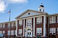
Circleville School
The Circleville School, found in Circleville, West Virginia, is a historic school building. Old schoolhouses often show us how education used to be. This school was listed in 1995, reminding us of the importance of learning through the years.
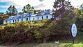
Franklin Historic District
The town of Franklin has a whole area that's considered historic! This "historic district" includes many old buildings and streets that together tell the story of the town's development. It was added to the Register in 1986, recognizing the collective history of this charming area. The Pendleton County Courthouse is one of the notable buildings within this district.
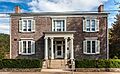
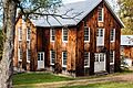
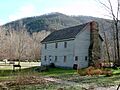
McCoy House
Also in Franklin, West Virginia, the McCoy House is a specific historic home. Old houses often have unique architectural styles and can give us clues about how people lived and designed their homes in earlier times. The McCoy House was listed in 1982.
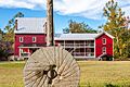
McCoy Mill
Another mill, the McCoy Mill, is also located near Franklin, West Virginia. Just like Boggs Mill, it highlights the importance of local industry and agriculture in the county's history. It joined the Register in 1986.
Old Judy Church
The Old Judy Church, located south of Petersburg, West Virginia, is a historic church building. Churches often serve as important community centers and reflect the religious and social life of the past. This church was listed in 1976.
Old Probst Church
Near Brandywine, West Virginia, you'll find the Old Probst Church. Like Old Judy Church, it's a significant religious landmark that tells us about the early settlers and their communities. It was added to the Register in 1986.
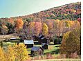
Pendleton County Poor Farm
The Pendleton County Poor Farm, near Upper Tract, West Virginia, is a unique historical site. In the past, "poor farms" were places where counties provided housing and work for people who couldn't support themselves. It's a reminder of how communities cared for their most vulnerable members. This farm was listed in 1986.
Ananias Pitsenbarger Farm
The Ananias Pitsenbarger Farm, located near Franklin, West Virginia, is another example of a historic farm. Farms are crucial to understanding the agricultural history and rural life of a region. This farm was added to the Register in 2011.
Priest Mill
The Priest Mill, near Franklin, West Virginia, is yet another historic mill in the county. The presence of so many mills shows how important water power and grain processing were to the economy of Pendleton County. It was listed in 2000.
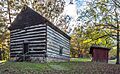
Sites Homestead
The Sites Homestead, found near the Seneca Rocks Visitor Center in Seneca Rocks, West Virginia, is a historic home that gives us a glimpse into pioneer life. Homesteads like this show how families settled and built their lives in the area. It was added to the Register in 1993.
These are just some of the amazing historic places in Pendleton County that are recognized for their importance. They help us connect with the past and understand the journey of the people who came before us.
Images for kids
-
Circleville School
-
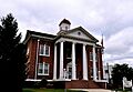
Pendleton County Courthouse, part of the Franklin Historic District
-
McCoy House
-
McCoy Mill
-
Old Judy Church
-

Old Probst Church
-
Pendleton County Poor Farm
-
Ananias Pitsenbarger Farm
-
Priest Mill
-
Sites Homestead


