
National Register of Historic Places listings in San Juan County, Washington facts for kids
The San Juan Islands in Washington State are full of amazing history! Many buildings, parks, and special places here are listed on the National Register of Historic Places. This is like a special list kept by the United States government to protect important places. When a place is on this list, it means it's really old and has a cool story to tell about American history, architecture, or culture. Let's explore some of these fantastic historic spots in San Juan County!
Historic Buildings and Homes
San Juan County has many old buildings that tell tales of the past.
Alderbrook Farmhouse
The Alderbrook Farmhouse is located in Doe Bay. It was added to the National Register of Historic Places on November 21, 1985. This old farmhouse gives us a peek into what farm life was like many years ago on the islands.
Crow Valley School
Imagine going to school in 1888! The Crow Valley School in Eastsound was built that year. It was added to the historic register on August 27, 1987. Today, the Orcas Island Historical Museum helps take care of this old school, so people can still visit and learn about its history.

Doe Bay General Store and Post Office
The Doe Bay General Store and Post Office is another historic spot in Doe Bay, on Orcas Island. It was listed on May 8, 1986. General stores were super important in the past, as they were often the only place to buy supplies and send mail in small communities.

Michael and Myra Donohue House
The Michael and Myra Donohue House in Eastsound was added to the list on January 9, 2013. This house is a great example of the homes built in the area a long time ago.
Emmanuel Episcopal Church
The Emmanuel Episcopal Church in Eastsound was built in 1885. It became a historic place on December 12, 1994. Churches like this often served as important community centers in the early days of the islands.

Little Red Schoolhouse
On Shaw Island, you can find the Little Red Schoolhouse. It was listed on June 19, 1973. This charming schoolhouse reminds us of how education began in these island communities.

Orcas Hotel
The Orcas Hotel was built in 1904 in Orcas. It joined the historic register on August 24, 1982. This beautiful hotel has welcomed visitors for over a hundred years!

Port Stanley School
The Port Stanley School on Lopez Island was added to the list on December 9, 1994. Like other old schoolhouses, it shows us how important learning was to the early settlers.

San Juan County Courthouse
The San Juan County Courthouse in Friday Harbor was built in 1906. It became a historic site on April 12, 1984. This building is where many important decisions for the county have been made over the years.

Historic Natural and Industrial Sites
Beyond buildings, some natural areas and old industrial sites are also protected for their history.
Krumdiack Homestead
The Krumdiack Homestead (also known as the Cook Property) is on the north coast of Waldron Island. It was recognized as a historic district on April 29, 1993. Homesteads were places where early settlers built their homes and farms.
Moran State Park
Moran State Park near Olga is a huge and beautiful park. It was added to the National Register on January 2, 2013. The park includes Mount Constitution, which offers amazing views of the islands.

Patos Island Light Station
The Patos Island Light Station is a lighthouse built in 1893 on Patos Island, north of Eastsound. It became a historic place on October 21, 1977. Lighthouses were crucial for guiding ships safely through the waters.

Roche Harbor
Roche Harbor is a historic district on northern San Juan Island. It was founded in 1886 and became a historic site on August 29, 1977. This area includes many old buildings and tells the story of a former lime company town.

Rosario (estate)
The Rosario estate is south of East Sound on Orcas Island. It was listed on November 2, 1978. This beautiful estate is right next to Moran State Park and has a rich history.

San Juan Island National Historical Park
The San Juan Island National Historical Park is a very important place. It was listed as a National Historic Site on October 15, 1966. This park tells the story of the "Pig War," a peaceful dispute between the United States and Great Britain over the island's ownership.

San Juan Island, Lime Kiln Light Station
The Lime Kiln Light (also known as the San Juan Island, Lime Kiln Light Station) is west of Friday Harbor. It was built in 1914 and became a historic site on December 15, 1978. This lighthouse is famous for being one of the best places to watch whales from shore!

San Juan Lime Company/Cowell's
The San Juan Lime Company/Cowell's site is also near Friday Harbor. It was added to the register on March 6, 2007. This area shows where lime was once produced, which was an important industry for the islands.

Tharald Homestead
The Tharald Homestead (also known as the Ellis Farm) is on Shaw Island. It was listed on January 17, 2002. This homestead helps us understand the farming history of the islands.
Images for kids
-
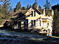
The Alderbrook Farmhouse in Doe Bay.

