
National Register of Historic Places listings in Scotts Bluff County, Nebraska facts for kids

Scotts Bluff County in Nebraska is home to many important historical places! These special spots are listed on the National Register of Historic Places. This is a list kept by the United States government to recognize buildings, sites, and objects that are important to American history, architecture, archaeology, engineering, or culture.
In Scotts Bluff County, there are 21 places on this list. Two of them are even more special: they are called National Historic Landmarks. This means they are considered extra important to the history of the entire country. Let's explore some of these amazing places!
Contents
Historic Landmarks and Monuments
Some places in Scotts Bluff County are so important they are recognized as National Historic Landmarks. These sites tell big stories about the past.
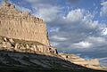
Scotts Bluff National Monument

The Scotts Bluff National Monument is a huge rock formation that stands tall in the landscape. For many years, it was a very important landmark for pioneers traveling west on trails like the Oregon Trail. Imagine how excited they must have been to see this giant bluff, knowing they were on the right path! It's located about 3 miles west of Gering.
Robidoux Pass

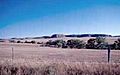
Robidoux Pass is another historic spot, found about 9 miles west of Gering. This pass was a popular route for travelers and traders in the mid-1800s. It was often used instead of the more difficult Mitchell Pass near Scotts Bluff. Many people passed through here on their way to new lives in the west.
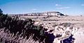
Signal Butte

West of Gering is Signal Butte. This site is incredibly old! It's important because it shows evidence of people living there thousands of years ago. Archaeologists have found tools and other items that help us understand early human life in this area.
Important Buildings and Structures
Many buildings in Scotts Bluff County are also on the National Register. These structures show us how people lived and worked in the past.
Fontenelle Apartment House
_from_E_1.JPG)
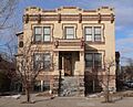
The Fontenelle Apartment House is located at 1424 4th Avenue in Scottsbluff. It was built a long time ago and is a good example of the architecture from its time. It was added to the Register in 1998.
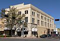
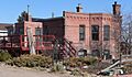
Gering Courier Building

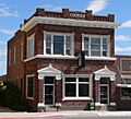
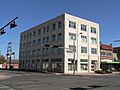
The Gering Courier Building at 1428 10th Street in Gering was once home to a local newspaper. Newspapers were very important for sharing news and information in the community before the internet and TV. This building was listed in 2004.
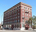
Lincoln Hotel
_from_NW_2.JPG)
The Lincoln Hotel stands at 1421 Broadway in Scottsbluff. Hotels like this were vital places for travelers and a center for social life in the early 20th century. It became a historic place in 1998.
Marquis Opera House
_from_SW_3.JPG)
The Marquis Opera House at 1601-1603 Broadway in Scottsbluff was a place for entertainment. Imagine people gathering here to watch plays, concerts, and other performances! It was added to the Register in 1985.
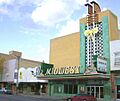
Midwest Theater

Another entertainment spot, the Midwest Theater at 1707 Broadway in Scottsbluff, is also on the list. Theaters like this were where people went to watch movies and live shows. It was listed in 1997.
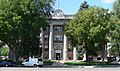
Scotts Bluff County Courthouse

The Scotts Bluff County Courthouse at 10th and Q Streets in Gering is where local government business happens. Courthouses are often grand buildings that represent justice and community. This one was listed in 1990.
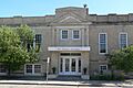
Scottsbluff Carnegie Library

The Scottsbluff Carnegie Library at 106 East 18th Street in Scottsbluff was built with money from Andrew Carnegie, a famous businessman who funded many libraries across the country. Libraries are important places for learning and reading. This building became historic in 1981.
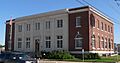
US Post Office-Scottsbluff

The US Post Office-Scottsbluff at 120 East 16th Street in Scottsbluff is another important public building. Post offices have always been key for communication, allowing people to send letters and packages. It was listed in 1989.
Other Notable Sites
Scotts Bluff County has many other interesting places that are part of its history.
Fort Mitchell Site

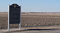
The Fort Mitchell Site is southwest of Scottsbluff. This was once a military fort built to protect travelers on the Oregon Trail. It played a role in the history of westward expansion. It was listed in 1978.
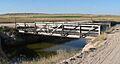
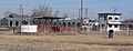
Henry State Aid Bridges

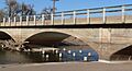
The Henry State Aid Bridges cross the North Platte River south of Henry. Bridges are crucial for connecting communities and allowing travel. These bridges were built with state aid, showing how important they were for transportation. They were listed in 1992.
Interstate Canal Bridge
_old_bridge_2.JPG)
The Interstate Canal Bridge is on a county road about 9.3 miles north of Scottsbluff. Canals and the bridges over them are important for irrigation, bringing water to farms. This bridge was listed in 1992.
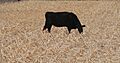
Knorr-Holden Continuous Corn Plot

The Knorr-Holden Continuous Corn Plot is part of the Scottsbluff Experiment Station. This isn't a building, but a special farm plot! It's important for agricultural science, where researchers study how to grow corn better. It was listed in 1992.
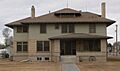
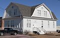
M.B. Quivey House
_from_E_1.JPG)
The M.B. Quivey House is at 1462 19th Avenue in Mitchell. This house is a historic home, representing the kind of places people lived in the past. It was added to the Register in 1983.
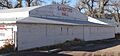
Saddle Club
_arena_1.JPG)
The Saddle Club at 2000 West Overland in Scottsbluff is a place related to horse riding and community events. It was listed in 2007.
Sandford Hall
_3.JPG)
Sandford Hall is located at 130625 County Road E in Mitchell. This building likely served as a community hall or a place for gatherings. It was listed in 1997.
Severin Sorensen House
_from_SW_1.JPG)
The Severin Sorensen House at 2345 17th Street in Gering is another historic home. It was listed in 1983.
Tri-State Land Company Headquarters Building
_from_SW_1.JPG)
The Tri-State Land Company Headquarters Building at 13 West Overland Street in Scottsbluff was important for land development and settlement in the area. It was listed in 1997.
Western Public Service Building

The Western Public Service Building at 1721 Broadway in Scottsbluff was likely home to a utility company, providing services like electricity or gas to the community. It was listed in 2004.
Images for kids
-
The Fontenelle Apartment House
-
A historical marker for Fort Mitchell
-
The Gering Courier Building
-
One of the Henry State Aid Bridges
-
An old bridge over the Interstate Canal
-
The Knorr-Holden Continuous Corn Plot
-
The Lincoln Hotel
-
The Marquis Opera House
-
The Midwest Theater
-
The M.B. Quivey House
-
Robidoux Pass
-
The Saddle Club arena
-
Sandford Hall
-
The Scotts Bluff County Courthouse
-
Scotts Bluff National Monument
-
The Scottsbluff Carnegie Library
-
Signal Butte
-
The Severin Sorensen House
-
The Tri-State Land Company Headquarters Building
-
The Scottsbluff Post Office
-
The Western Public Service Building
