National Register of Historic Places listings in Uinta County, Wyoming facts for kids
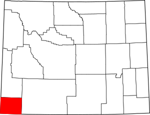
Have you ever wondered about old buildings and places that tell a story? In Uinta County, Wyoming, there are many special spots that are part of the National Register of Historic Places. This is like a special list kept by the United States government. It helps protect important buildings, areas, and objects that have a big meaning in American history, architecture, archaeology, engineering, or culture.
When a place is on this list, it means it's recognized as a valuable part of our past. It helps people learn about how things used to be and why certain places are important. In Uinta County, there are 14 different places and areas that have earned a spot on this special list. Let's explore some of them!
Contents
What is the National Register of Historic Places?
The National Register of Historic Places is the official list of the nation's historic places. It is part of a national program to coordinate and support public and private efforts. This program helps to identify, evaluate, and protect America's historic and archaeological resources.
Why are places listed?
Places are listed for many reasons. They might be very old, show a special way of building, or be connected to important events or people. Being on the list helps save these places so future generations can also learn from them. It's like a hall of fame for historic sites!
Historic Places in Uinta County
Uinta County is full of history, especially because of its role in the American West. Many of its listed places are connected to railroads, early settlements, and important events.
Downtown Evanston Historic District
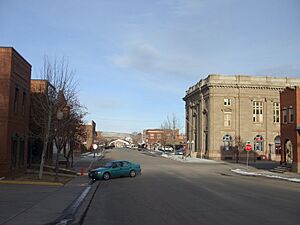
The Downtown Evanston Historic District is a special area in the city of Evanston, Wyoming. It includes many buildings that show what the town looked like a long time ago. This district is roughly bordered by Center, 9th, 11th, and Front Streets. It was added to the National Register in 1983. Walking through this area is like taking a step back in time!
ERT Bridge over Black's Fork
Near Fort Bridger, Wyoming, you can find the ERT Bridge over Black's Fork. This bridge is located on County Road CN19-217. It was recognized for its historical importance in 1985. Bridges like this one are important because they show how people traveled and built things in the past.
Fort Bridger
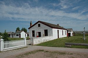
Fort Bridger is a very famous historic site in Uinta County. It's located on Black's Fork of the Green River, near the town of Fort Bridger. This fort was first established in 1843 by Jim Bridger and Louis Vasquez as a trading post. It later became an important stop for pioneers traveling on the Oregon Trail, California Trail, and Mormon Trail. Fort Bridger was added to the National Register in 1969. It's a great place to learn about the pioneers and the Old West.
Piedmont Charcoal Kilns
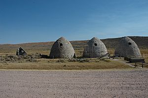
About 14 miles northeast of Hilliard, Wyoming, you can find the Piedmont Charcoal Kilns. These unique structures were built in 1869. They were used to make charcoal, which was needed for the nearby iron smelters that helped build the Union Pacific Railroad. The kilns are a cool example of industrial history in Wyoming. They were listed in 1971.
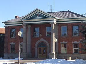
Uinta County Courthouse
The Uinta County Courthouse is a grand building located on Courthouse Square in Evanston, Wyoming. This building has been the center of local government for many years. It was added to the National Register in 1977. Courthouses often have interesting architecture and play a big role in a community's history.
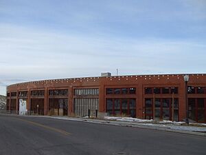
Union Pacific Railroad Complex
The Union Pacific Railroad Complex in Evanston, Wyoming, is a large historical area. It's located around Main and 15th Streets. This complex includes buildings like the famous roundhouse, where trains were turned around and repaired. The railroad was super important for the growth of Wyoming and the whole country. This complex was listed in 1985. It shows how vital railroads were for transportation and industry.
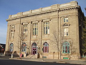
US Post Office-Evanston Main
The old US Post Office building in Evanston, Wyoming, is located at 221 10th Street. This building served as the main post office for many years. Post offices are important historical buildings because they were central to communication and community life. This one was added to the National Register in 1987.
Other Notable Places
Uinta County has other interesting historic sites too. These include old houses and churches that tell stories about the people who lived there.
- A. V. Quinn House: Located at 1049 Center Street in Evanston, this house was listed in 1984.
- St. Paul's Episcopal Church: Found at 10th and Sage Streets in Evanston, this church was listed in 1980.
These places, and others like the Bridger Antelope Trap and the Brigham Young Oil Well, all help us understand the rich history of Uinta County and Wyoming. They are reminders of the past and important landmarks for the future.


