
National Register of Historic Places listings in Warren County, Mississippi facts for kids

This article is about the amazing historic places in Warren County, Mississippi, especially in the city of Vicksburg, Mississippi. These places are so special that they are listed on the National Register of Historic Places. Think of it like a special hall of fame for buildings, battlefields, and other spots that have played a big part in history!
There are 75 places in Warren County that are on this important list. Three of them are even more special and are called National Historic Landmarks. These landmarks are super important to the history of the whole United States. You'll find old houses, battlefields, and even a historic ship!
Contents
What is the National Register of Historic Places?
The National Register of Historic Places is the official list of the nation's historic places that are worth saving. It's like a special club for buildings, sites, structures, objects, and districts that are important in American history, architecture, archaeology, engineering, or culture. When a place is on this list, it means it's recognized for its unique story and value. It helps protect these places for future generations to enjoy and learn from.
Exploring Warren County's Historic Sites
Warren County is full of fascinating history, especially around Vicksburg, which played a big role in the American Civil War. Many of the places on this list tell stories of battles, everyday life long ago, and important people.
Historic Homes and Buildings
Many of the listings are beautiful old homes and buildings. These structures show us how people lived and what kind of architecture was popular many years ago.
- Anchuca: This grand home in Vicksburg is a great example of old Southern architecture. It's a beautiful place with a lot of history.
- Biedenharn Candy Company Building: This building is famous because it's where Coca-Cola was first bottled! Imagine, a sweet piece of history right here.
- Duff Green House: Another stunning Vicksburg home, this one served as a hospital during the Civil War. It has many stories to tell.
- Old Warren County Courthouse: This building is a National Historic Landmark. It's a very important building where many historical events took place. It's a symbol of Vicksburg's past.
- Pemberton's Headquarters: This was the headquarters for Confederate General John C. Pemberton during the Siege of Vicksburg. It's a key spot for understanding the Civil War.
Battlefields and Military Sites
Because of Vicksburg's role in the Civil War, several battlefields and military sites are on the list. These places help us remember the important events that happened there.
- Big Black River Battlefield: This was the site of a Civil War battle near Bovina. It was an important step in the Vicksburg Campaign.
- Chickasaw Bayou Battlefield: Located north of Vicksburg, this was another significant battle site during the Civil War.
- Vicksburg National Military Park: This huge park is a National Historic Landmark. It protects the battlefield and monuments from the Siege of Vicksburg, a major turning point in the Civil War. You can explore the old trenches and see where history happened.
- USS Cairo (1861): This is a unique listing! The USS Cairo was a Union ironclad gunboat that sank during the Civil War. It was later raised from the river and is now on display at the Vicksburg National Military Park. It's a National Historic Landmark and a real piece of naval history.
Other Interesting Places
The list also includes other types of historic places, like bridges, cemeteries, and even archaeological sites.
- Mississippi River Bridge (Old Vicksburg Bridge): This old bridge crosses the mighty Mississippi River. It's an impressive structure that has been important for travel and trade for many years.
- Anshe Chesed Cemetery: This historic cemetery tells the story of the Jewish community in Vicksburg.
- Fort St. Pierre Site: This archaeological site is a National Historic Landmark. It's where an old French fort once stood, showing us about even earlier history in the area.
Current listings
| Name on the Register | Image | Date listed | Location | City or town | Description | |
|---|---|---|---|---|---|---|
| 1 | 1300 Grove Street House |
(#83003976) |
1300 Grove St. 32°21′03″N 90°52′28″W / 32.350833°N 90.874444°W |
Vicksburg | ||
| 2 | Anchuca |
 |
(#82003113) |
1010 1st E. St. 32°21′16″N 90°52′38″W / 32.354444°N 90.877222°W |
Vicksburg | |
| 3 | Anshe Chesed Cemetery |
(#14000569) |
Grove St. 32°20′43″N 90°51′14″W / 32.3454°N 90.8539°W |
Vicksburg | ||
| 4 | Balfour House |
 |
(#71000458) |
1002 Crawford St. 32°20′51″N 90°52′43″W / 32.3475°N 90.878611°W |
Vicksburg | |
| 5 | Beck House |
(#79001336) |
1101 South St. 32°20′52″N 90°52′38″W / 32.347778°N 90.877222°W |
Vicksburg | ||
| 6 | Belle Fleur |
(#92000469) |
1123 South St. 32°20′52″N 90°53′17″W / 32.347778°N 90.888056°W |
Vicksburg | ||
| 7 | Bethel African Methodist Episcopal Church |
(#92000858) |
805 Monroe St. 32°21′16″N 90°52′44″W / 32.354444°N 90.878889°W |
Vicksburg | ||
| 8 | Beulah Cemetery |
(#92001404) |
Junction of Openwood St. and Old Jackson Rd. 32°21′26″N 90°50′59″W / 32.357222°N 90.849722°W |
Vicksburg | ||
| 9 | Biedenharn Candy Company Building |
 |
(#77000793) |
1107-1109 Washington St. 32°21′05″N 90°52′53″W / 32.351389°N 90.881389°W |
Vicksburg | |
| 10 | Big Black River Battlefield |
.jpg) |
(#71000451) |
On both banks of the Big Black River between Smith's Station and Bovina 32°21′36″N 90°43′35″W / 32.36°N 90.726389°W |
Bovina | Extends into Hinds County |
| 11 | Big Black River Railroad Bridge |
 |
(#88002418) |
Spans the Big Black River east of Bovina 32°20′49″N 90°42′17″W / 32.346944°N 90.704722°W |
Bovina | Extends into Hinds County |
| 12 | Blum House |
(#92000859) |
1420 Cherry St. 31°37′36″N 90°53′45″W / 31.626667°N 90.895833°W |
Vicksburg | ||
| 13 | Bobb House |
(#79001337) |
1503 Harrison St. 32°20′45″N 90°52′21″W / 32.345833°N 90.8725°W |
Vicksburg | ||
| 14 | Isaac Bonham House |
(#77000794) |
601 Klein St. 32°20′29″N 90°53′06″W / 32.341389°N 90.885°W |
Vicksburg | ||
| 15 | Carr Junior High School |
(#00001055) |
1805 Cherry St. 32°20′41″N 90°52′42″W / 32.344722°N 90.878333°W |
Vicksburg | ||
| 16 | Cedar Grove |
 |
(#76001107) |
2200 Oak St. 32°20′25″N 90°53′08″W / 32.340278°N 90.885556°W |
Vicksburg | |
| 17 | Chickasaw Bayou Battlefield |
(#73001028) |
North of Vicksburg on U.S. Route 61 32°24′45″N 90°51′24″W / 32.4125°N 90.856667°W |
Vicksburg | Site of the Battle of Chickasaw Bayou | |
| 18 | Christian and Brough Building |
(#14000278) |
923 Washington St. 32°21′12″N 90°52′53″W / 32.35329°N 90.881404°W |
Vicksburg | ||
| 19 | Church of the Holy Trinity |
 |
(#78001633) |
South and Monroe Sts. 32°20′50″N 90°52′47″W / 32.347222°N 90.879722°W |
Vicksburg | |
| 20 | Confederate Avenue Brick Arch Bridge |
(#88002421) |
Confederate Ave. 32°19′44″N 90°52′31″W / 32.328889°N 90.875278°W |
Vicksburg | ||
| 21 | Craig-Flowers House |
.jpg) |
(#84002352) |
2011 Cherry St. 32°20′29″N 90°52′43″W / 32.341389°N 90.878611°W |
Vicksburg | |
| 22 | Davis-Mitchell House |
 |
(#82003114) |
901 Crawford St. 32°20′57″N 90°52′46″W / 32.349167°N 90.879444°W |
Vicksburg | |
| 23 | Fairground Street Bridge |
 |
(#88002420) |
Spans the Illinois Central railroad yard on Fairground St. 32°20′16″N 90°53′25″W / 32.337778°N 90.890278°W |
Vicksburg | |
| 24 | Federal Fortifications Along Bear Creek |
(#74001066) |
Southwest of Youngton 32°25′40″N 90°38′06″W / 32.427778°N 90.635°W |
Youngton | ||
| 25 | Feld House |
(#82003115) |
2108 Cherry St. 32°20′26″N 90°52′46″W / 32.340556°N 90.879444°W |
Vicksburg | ||
| 26 | Fitz-Hugh Hall |
(#86003030) |
1322 Chambers St. 32°20′18″N 90°52′41″W / 32.338333°N 90.878056°W |
Vicksburg | ||
| 27 | Col. Charles C. Flowerree House |
 |
(#75001058) |
2309 Pearl St. 32°20′25″N 90°53′14″W / 32.340278°N 90.887222°W |
Vicksburg | |
| 28 | Fonsylvania |
(#84002355) |
Fisher Ferry Rd., south of Vicksburg 32°11′33″N 90°49′14″W / 32.1925°N 90.820556°W |
Vicksburg | ||
| 29 | Fort St. Pierre Site |
(#00000263) |
Off U.S. Route 61 north of Vicksburg 32°29′44″N 90°47′55″W / 32.4956°N 90.7986°W |
Vicksburg | ||
| 30 | The Galleries |
(#80002303) |
2421 Marshall St. 32°20′14″N 90°53′04″W / 32.337222°N 90.884444°W |
Vicksburg | ||
| 31 | Glenwood-Vicklan Historic District |
(#09000886) |
Including Vicklan St., Glenwood Cir., Edna Dr., and Chambers St. east of the bayou 32°20′20″N 90°52′14″W / 32.338778°N 90.87065°W |
Vicksburg | ||
| 32 | Duff Green House |
 |
(#79001338) |
806 Locust St. 32°21′15″N 90°52′32″W / 32.354167°N 90.875556°W |
Vicksburg | |
| 33 | Grove Street Houses |
(#80002304) |
1117 and 1121 Grove St. 32°21′06″N 90°52′34″W / 32.351667°N 90.876111°W |
Vicksburg | ||
| 34 | Grove Street-Jackson Historic District |
 |
(#05001613) |
Along Grove and Jackson Sts. between Cherry St. and 1st N. St. 32°21′07″N 90°52′33″W / 32.351856°N 90.875906°W |
Vicksburg | |
| 35 | Guider House |
(#80002305) |
1115 Grove St. 32°21′05″N 90°52′35″W / 32.351389°N 90.876389°W |
Vicksburg | ||
| 36 | P.M. Harding House |
(#86001674) |
1402 Chambers St. 32°20′18″N 90°52′35″W / 32.338333°N 90.876389°W |
Vicksburg | ||
| 37 | Hotel Vicksburg |
 |
(#79001339) |
801 Clay St. 32°21′00″N 90°52′50″W / 32.35°N 90.880556°W |
Vicksburg | |
| 38 | Joel and Margaret Hullum House |
(#84002358) |
749 Mallet Rd. 32°12′47″N 90°52′27″W / 32.213056°N 90.874167°W |
Vicksburg | ||
| 39 | Hyland Mound Archeological Site |
(#01000920) |
Address Restricted |
Vicksburg | ||
| 40 | Jackson Street Missionary Baptist Church |
(#100000538) |
1416 Jackson St. 32°21′07″N 90°52′20″W / 32.351957°N 90.872135°W |
Vicksburg | ||
| 41 | Fannie Willis Johnson House |
(#88000241) |
2430 Drummond St. 32°20′09″N 90°52′54″W / 32.335833°N 90.881667°W |
Vicksburg | ||
| 42 | Dr. Isaac Cecil Knox House |
(#90001478) |
2823 Confederate Ave. 32°19′14″N 90°53′02″W / 32.320556°N 90.883889°W |
Vicksburg | ||
| 43 | John Lane House |
 |
(#82003116) |
905 Crawford St. 32°20′56″N 90°52′45″W / 32.348889°N 90.879167°W |
Vicksburg | |
| 44 | W.W. Lassiter Wholesale Grocery Warehouse |
(#94000149) |
1308 Levee St. 32°21′01″N 90°53′03″W / 32.350278°N 90.884167°W |
Vicksburg | ||
| 45 | Loosa Yokena Archeological Site |
(#01000481) |
Address Restricted |
Kimberly | ||
| 46 | Luckett Compound |
 |
(#83000968) |
1116-1122 Crawford St 32°20′53″N 90°52′36″W / 32.348056°N 90.876667°W |
Vicksburg | |
| 47 | The Magnolias |
(#87000217) |
1617 Monroe St. 32°20′43″N 90°52′49″W / 32.345278°N 90.880278°W |
Vicksburg | ||
| 48 | Magruder-Morrissey House |
(#84002361) |
1117 Cherry St. 32°21′03″N 90°52′40″W / 32.350833°N 90.877778°W |
Vicksburg | ||
| 49 | Main Street Historic District |
 |
(#79001340) |
1st East, Adams, Main, and Openwoods Sts.; also roughly bounded by Adams St., Main St., Cherry St., and 1st East St. 32°21′12″N 90°52′32″W / 32.353333°N 90.875556°W |
Vicksburg | Second set of boundaries represents a boundary increase of January 5, 1989 |
| 50 | McDermott House |
(#84002359) |
1100 South St. 32°20′50″N 90°52′40″W / 32.347222°N 90.877778°W |
Vicksburg | ||
| 51 | McNutt House |
 |
(#75001059) |
Northwestern corner of Monroe and E. 1st Sts. 32°21′17″N 90°52′45″W / 32.354722°N 90.879167°W |
Vicksburg | |
| 52 | Mississippi River Bridge |
 |
(#88002423) |
Spans the Mississippi River on Old U.S. Route 80 32°18′54″N 90°54′20″W / 32.315°N 90.905556°W |
Vicksburg | Extends into Madison Parish, Louisiana |
| 53 | Old Courthouse, Warren County |
.jpg) |
(#68000029) |
Court Sq. 32°21′07″N 90°52′43″W / 32.351944°N 90.878611°W |
Vicksburg | |
| 54 | Pemberton's Headquarters |
 |
(#70000319) |
1018 Crawford St. 32°20′54″N 90°52′40″W / 32.348333°N 90.877778°W |
Vicksburg | |
| 55 | Planters Hall |
 |
(#71000459) |
822 Main St. 32°21′14″N 90°52′46″W / 32.353889°N 90.879444°W |
Vicksburg | |
| 56 | Adolph Rose Building |
(#92001567) |
717 Clay St. 32°21′01″N 90°52′55″W / 32.350278°N 90.881944°W |
Vicksburg | ||
| 57 | St. Francis Xavier Convent |
 |
(#77000796) |
1021 Crawford St. 32°20′55″N 90°52′39″W / 32.348611°N 90.8775°W |
Vicksburg | |
| 58 | Shlenker House |
(#83003975) |
2212 Cherry St. 32°20′19″N 90°52′45″W / 32.338611°N 90.879167°W |
Vicksburg | ||
| 59 | Snyder's Bluff |
(#73001027) |
Along the Yazoo River north of Redwood 32°29′51″N 90°47′53″W / 32.4975°N 90.7981°W |
Redwood | ||
| 60 | South Cherry Street Historic District |
 |
(#03001140) |
Along Cherry and Drummond Sts. from Harrison St. to Bowmar St. and including Chambers and Baum Sts. 32°20′25″N 90°52′42″W / 32.340278°N 90.878333°W |
Vicksburg | |
| 61 | South Drummond Street Neighborhood Historic District |
(#15000667) |
Roughly bounded by Bowmar & Confederate Aves., Yerger, Green, 2nd, Oak Hill & Polk Sts., Halls Ferry Rd. 32°19′52″N 90°53′08″W / 32.331°N 90.8855°W |
Vicksburg | ||
| 62 | South Vicksburg Public School No. 200 |
(#86000482) |
900 Speed St. 32°20′18″N 90°53′06″W / 32.338333°N 90.885°W |
Vicksburg | ||
| 63 | Uptown Vicksburg Historic District |
 |
(#93000850) |
Roughly bounded by Locust, South, Washington, and Clay Sts.; also mostly on Washington St. between Grove and Veto Sts. 32°20′55″N 90°52′45″W / 32.348611°N 90.879167°W |
Vicksburg | Second set of boundaries represents a boundary increase of September 10, 2004 |
| 64 | U.S.S. CAIRO |
 |
(#71000068) |
U.S.S. Cairo Museum 32°22′33″N 90°52′00″W / 32.375833°N 90.866667°W |
Vicksburg | |
| 65 | Vicksburg National Military Park |
 |
(#66000100) |
North and east of Vicksburg 32°20′28″N 90°51′44″W / 32.341111°N 90.862222°W |
Vicksburg | |
| 66 | Old Vicksburg Public Library |
 |
(#92000857) |
819 South St. 32°20′53″N 90°52′51″W / 32.348056°N 90.880833°W |
Vicksburg | |
| 67 | Vicksburg Siege Cave |
(#73001029) |
Near the Vicksburg City Cemetery 32°21′59″N 90°51′41″W / 32.366389°N 90.861389°W |
Vicksburg | ||
| 68 | Walnut Hills |
 |
(#82003117) |
1214 Adams St. 32°20′59″N 90°52′39″W / 32.349722°N 90.8775°W |
Vicksburg | |
| 69 | Waterways Experiment Station |
(#00001511) |
Roughly bounded by Spillway, Durden Creek, Tennessee Rd., and Dam Spillway 32°17′50″N 90°52′10″W / 32.297222°N 90.869444°W |
Vicksburg | ||
| 70 | Yazoo And Mississippi Valley Depot |
 |
(#79001341) |
500 Grove St. 32°21′09″N 90°52′59″W / 32.352553°N 90.882924°W |
Vicksburg | |
| 71 | Yokena Presbyterian Church |
(#84002442) |
South of Vicksburg on U.S. Route 61 32°10′24″N 90°56′31″W / 32.173333°N 90.941944°W |
Vicksburg | ||
| 72 | Young-Bradfield House |
 |
(#82003118) |
913 Crawford St. 32°20′56″N 90°52′44″W / 32.348889°N 90.878889°W |
Vicksburg |
Former Listings: Places That Were Once Historic
Sometimes, places are removed from the National Register. This can happen if they are destroyed or if they lose their historic importance. Here are a couple of examples from Warren County.
| Name on the Register | Image | Date listed | Date removed | Location | City or town | Summary | |
|---|---|---|---|---|---|---|---|
| 1 | Confederate Avenue Steel Arch Bridge |
 |
(#88002483) |
|
Spans Jackson Rd. in Vicksburg National Military Park |
Vicksburg | This bridge was taken down in June 2002. |
| 2 | Sprague |
 |
(#77000795) |
|
Vicksburg Harbor |
Vicksburg | This historic towboat was unfortunately destroyed by a fire. |
Images for kids
-
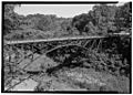
The Confederate Avenue Steel Arch Bridge, which was removed in 2002.
-
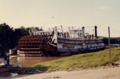
The towboat Sprague, which was destroyed by fire.
