
National Register of Historic Places listings in southern New Castle County, Delaware facts for kids
The National Register of Historic Places is like a special list of important buildings, places, and areas in the United States. These places are chosen because they have a lot of history, special architecture, or are important to how our country developed. When a place is on this list, it means it's recognized as a valuable part of our shared past.
This article lists the historic places in southern New Castle County, Delaware. This part of the county is south of the Chesapeake and Delaware Canal, which is a waterway connecting the Chesapeake Bay and the Delaware River.
There are 390 historic places listed in all of New Castle County. Out of these, 87 are located in the southern part of the county, and you'll find them listed here. One of these places is even more special because it's also a National Historic Landmark, which is the highest level of historical recognition in the U.S. Other historic places in New Castle County are listed separately for Wilmington and northern New Castle County.
Historic Places in Southern New Castle County
This section lists many of the special places in southern New Castle County that are on the National Register of Historic Places. Each entry tells you the name of the place, where it is, and sometimes a little bit about why it's important.
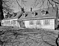
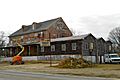
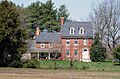
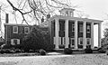
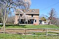
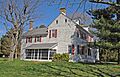
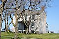
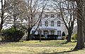
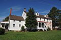
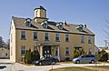
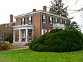
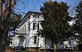
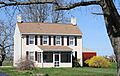
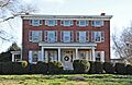
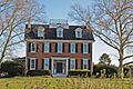
- Achmester
- Location: 617 Marl Pit Rd., Middletown
- This historic place was added to the list in 1979.
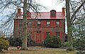
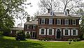
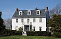
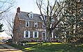
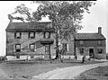
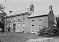
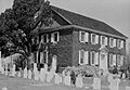
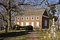
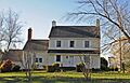
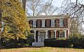
- Appoquinimink Friends Meetinghouse
- Location: 624 Main St., Odessa
- This very small brick meetinghouse was used as a station on the Underground Railroad, a secret network that helped enslaved people find freedom. It was listed in 1972.
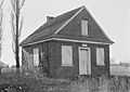
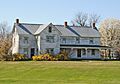
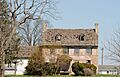
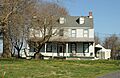
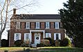
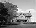
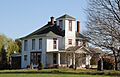
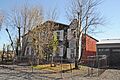
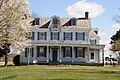
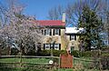
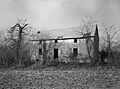
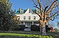
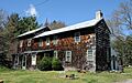
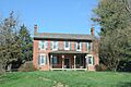
- Armstrong-Walker House
- Location: 5036 Summit Bridge Rd., Middletown
- This house became a historic site in 1985.
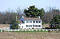
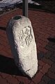
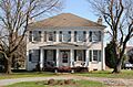
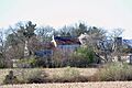
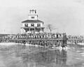
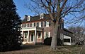
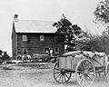
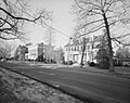
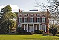
- Ashton Historic District
- Location: North of Port Penn on Thorntown Rd., Port Penn
- This is a historic area, or district, that was recognized in 1978.
- Augustine Beach Hotel
- Location: 1919 Augustine Beach Rd., near Port Penn
- This old hotel was added to the list in 1973.
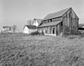
- Duncan Beard Site
- Location: 1.4 miles southeast on Delaware Route 299 from the intersection with U.S. Route 13, Odessa
- This site was recognized in 1973.
- Belleview
- Location: 855 Shallcross Lake Rd., Middletown
- Belleview was added to the National Register in 1985.
- Biddle House
- Location: 2120 DuPont Parkway, Biddles Corner
- This house was listed in 1978.
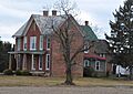
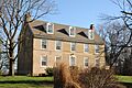
- Gov. Benjamin T. Biggs Farm
- Location: 1196 Choptank Rd., Middletown
- This farm, once owned by Governor Benjamin T. Biggs, was recognized in 1987.
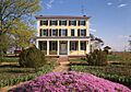
- Brook Ramble
- Location: 295 Grears Corner Rd., Townsend
- Brook Ramble was added to the list in 1992.
- Choptank
- Location: 1542 Choptank Rd., Middletown
- This property was listed in 1985.
- Choptank-Upon-The-Hill
- Location: 121 Colonel Clayton Dr., Middletown
- This site was recognized in 1985.
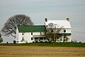
- Clearfield Farm
- Location: 867 Smyrna Landing Rd., Smyrna
- Clearfield Farm became a historic place in 1973.
- Cleaver House
- Location: 713 Port Penn Rd., Port Penn
- This house was added to the list in 1985.
- Cochran Grange
- Location: 704 Middletown-Warwick Rd., Middletown
- Cochran Grange was listed in 1973.
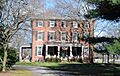
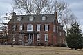
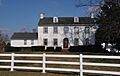
- Corbit-Sharp House
- Location: 118 Main St., Odessa
- This house is a National Historic Landmark, meaning it's very important to the history of the United States. It was listed in 1967.
- Cornucopia
- Location: 1377 Bethel Church Rd., Middletown
- Cornucopia was recognized as historic in 1987.
- Delaware Boundary Markers
- Location: Along the Delaware state boundary lines with Maryland and Pennsylvania
- These markers, which show the borders of Delaware, were listed as a historic district in 1975.
- Dilworth House
- Location: Off Delaware Route 9, Port Penn
- This house was added to the list in 1973.
- A. Eliason House
- Location: 4353 Summit Bridge Rd., Mt. Pleasant
- This house was listed in 1985.
- Elm Grange
- Location: 2424 DuPont Parkway, Odessa
- This historic site was listed in 1985 but was torn down between 2007 and 2009.
- Fairview (Odessa, 1850)
- Location: 781 Lorewood Grove Rd., Odessa
- This Fairview property was listed in 1985.
- Fairview (Odessa, 1733)
- Location: 602 Old State Rd., Odessa
- Also known as the "Mayor James Moore House," this older Fairview was listed in 1984.
- Fairview (Middletown)
- Location: 3 East Stonewall Dr., Middletown
- This Fairview property was recognized in 1987.
- Fields Heirs
- Location: Off U.S. Route 301, Middletown
- This site was listed in 1985 but was demolished between 1992 and 2002.
- Fleming House
- Location: 992 Flemings Landing Rd., Smyrna
- The Fleming House was added to the National Register in 1980.
- J. M. Gordon House
- Location: 910 Vance Neck Rd., Odessa
- This house was listed in 1985.
- Green Meadow
- Location: 484 Thomas Landing Rd. (Road 440), Odessa
- Green Meadow was recognized as a historic place in 1992.
- Greenlawn
- Location: 671 N. Broad St., Middletown
- This property was listed in 1973 but was torn down around 1985.
- Robert Grose House
- Location: 1000 Port Penn Rd., Port Penn
- This house was listed in 2001 but was demolished between 2002 and 2006.
- B. F. Hanson House
- Location: 1130 Middletown-Warwick Rd., Middletown
- The B. F. Hanson House was added to the list in 1982.
- Hart House
- Location: 477 Cedar Swamp Rd., Taylors Bridge
- This house was recognized in 1973.
- Hazel Glen
- Location: 1920 Pole Bridge Rd., Port Penn
- Hazel Glen was listed in 1978 but was demolished before 1991.
- Hedgelawn
- Location: 772 Middletown-Warwick Rd., Middletown
- Hedgelawn became a historic site in 1973.
- Hell Island Site
- Location: Address Restricted, Odessa
- This site's exact location is kept private for its protection. It was listed in 1977.
- S. Higgins Farm
- Location: 913 Ash Farm Way, Odessa
- This farm was added to the National Register in 1985.
- Hill Island Farm
- Location: 3381 Harris Rd., Middletown
- Hill Island Farm was recognized as historic in 1992.
- S. Holton Farm
- Location: 2010 Choptank Rd., Middletown
- This farm was listed in 1985.
- Huguenot House
- Location: 798 Taylors Bridge Rd., Taylors Bridge
- The Huguenot House was added to the list in 1973.
- Idalia Manor
- Location: 1870 DuPont Parkway, Mt. Pleasant
- Idalia Manor was recognized as historic in 1985.
- Johnson Home Farm
- Location: 166 Cedar Swamp Rd., Taylors Bridge
- This farm was listed in 1992 but was demolished between 1992 and 2002.
- Liston House
- Location: Cedar Swamp Rd., Taylors Bridge
- The Liston House was listed in 1973 but was demolished before 1991.
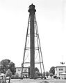
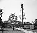
- Liston Range Front Lighthouse
- Location: 1600 Belts Rd., Bay View Beach
- This lighthouse, which helps guide ships, was added to the list in 2004.
- Liston Range Rear Light Station
- Location: West of Port Penn on Road 2, Port Penn
- This light station, another aid to navigation, was recognized in 1978.
- Comdr. Thomas MacDonough House
- Location: 2501 DuPont Parkway, Odessa
- This house, linked to Commander Thomas MacDonough, was listed in 1978.
- Maple Grove Farm
- Location: Delaware Route 299, Middletown
- This farm was listed in 1985 but was demolished between 1992 and 2002.
- Maples
- Location: 1023 Bunker Hill Rd., Middletown
- Maples was added to the National Register in 1978.
- Mayfield
- Location: 1603 Levels Rd., Middletown
- Mayfield was recognized as historic in 1997.
- McWhorter House
- Location: 606 Lorewood Grove Rd., Odessa
- This house was listed in 1985 but was demolished in 2004.
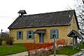
- Middletown Academy
- Location: 218 N. Broad St., Middletown
- The Middletown Academy was added to the list in 1972.
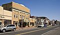
- Middletown Historic District
- Location: Roughly bounded by Redding, Scott, Lockwood, and Catherine Sts., Middletown
- This is a historic area in Middletown that was recognized in 1978.
- Misty Vale
- Location: 216 Manchester Way, Odessa
- Misty Vale was listed in 1985.
- Mondamon Farm
- Location: 381 Port Penn Rd., Odessa
- This farm was recognized as historic in 1985.
- Monterey
- Location: 692 Bayview Rd., Odessa
- Monterey was added to the National Register in 1980.
- Arnold S. Naudain House
- Location: 5567 Summit Bridge Rd., Middletown
- This house was listed in 1973.
- John B. Nelson House
- Location: 740 Dutch Neck Road, Port Penn
- The John B. Nelson House was recognized in 1978.
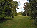
- Noxontown
- Location: Noxontown Road, Middletown
- Noxontown was added to the list in 1973.
- Odessa Historic District
- Location: Bounded roughly by Appoquinimink Creek on the southeast, High St. on the northeast, 4th St. on the northwest, and Main St. on the southwest, Odessa
- This historic district in Odessa was first recognized in 1971.
- Okolona
- Location: 1321 Shallcross Lake Rd., Middletown
- Okolona was listed in 1985.
- Old Brick Store
- Location: 670 Brick Store Landing Rd., Smyrna
- This store, built in 1767, was recognized as historic in 1973.
- Old Drawyers Church
- Location: 2839 DuPont Parkway, Odessa
- This old church was added to the National Register in 1973.
- Old Ford Dairy
- Location: 1871 DuPont Parkway, Odessa
- This dairy was listed in 1985 but was torn down between 2007 and 2009.
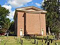
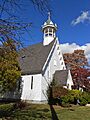
- Old St. Anne's Church
- Location: 105 St Annes Church Rd., Middletown
- This historic church was recognized in 1973.
- Old St. Paul's Methodist Episcopal Church
- Location: 506 High St., Odessa
- This church was added to the list in 1982.
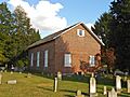
- Old Union Methodist Church
- Location: 205 Union Church Road, Townsend
- This old church was recognized as historic in 1973.
- Pharo House
- Location: 100 Silver Lake Rd., Middletown
- The Pharo House was listed in 1984.
- Port Penn Historic District
- Location: Delaware Route 9, Port Penn
- This historic district in Port Penn was recognized in 1978.
- Philip Reading Tannery
- Location: 201 E. Main St., Middletown
- This tannery was listed in 1978 but was demolished between 1992 and 2002.
- Reedy Island Range Rear Light
- Location: 1171 Taylors Bridge Rd., Taylors Bridge
- This lighthouse was added to the National Register in 1989.
- Retirement Farm
- Location: 2256 DuPont Parkway, Odessa
- Retirement Farm was listed in 1985.
- Riverdale
- Location: 1211 Silver Run Rd. in St Georges Hundred, Odessa
- Riverdale was recognized as historic in 1985.
- Rosedale
- Location: 1143 Bunker Hill Rd., Middletown
- Rosedale was added to the list in 1985.
- Rumsey Farm
- Location: 829 Middletown-Warwick Rd., Middletown
- This farm was listed in 1978 but was torn down between 2011 and 2013.
- St. Joseph's Church
- Location: 15 W. Cochran St., Middletown
- St. Joseph's Church was recognized as historic in 1978.
- J. Shallcross House
- Location: 557 Middletown-Odessa Rd., Middletown
- This house was listed in 1985.
- Sereck Shallcross House
- Location: 833 Marl Pit Rd., Odessa
- This house was added to the National Register in 1973.
- David W. Thomas House
- Location: 326 Thomas Landing Rd., Odessa
- The David W. Thomas House was recognized in 1992.
- Townsend Historic District
- Location: Roughly bounded by Gray, Ginn and South, Lattamus and Main Sts., and Commerce St. and Cannery Ln. and Railroad Ave., Townsend
- This historic district in Townsend was listed in 1986.
- A. M. Vail House
- Location: 521 Middletown-Odessa Rd., Middletown
- This house was listed in 1985 but was demolished between 2007 and 2009.
- Vandyke-Heath House
- Location: 385 Green Spring-Vandyke Rd. (Road 47), Townsend
- The Vandyke-Heath House was recognized in 1992.
- Charles C. Weldon House
- Location: Road 44, Odessa
- This house was listed in 1985.
- Weston
- Location: 4677 Summit Bridge Rd., Middletown
- Weston was added to the National Register in 1985.
- Williams House
- Location: 993 Marl Pit Rd., Odessa
- The Williams House was recognized as historic in 1973.
- Windsor
- Location: 1060 Dutch Neck Rd., Port Penn
- Windsor was listed in 1992.
- Woodside
- Location: 1358 Choptank Rd., Mt. Pleasant
- Woodside was added to the National Register in 1985.
Images for kids
-
Achmester
-
Appoquinimink Friends Meetinghouse
-
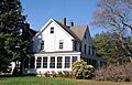
Armstrong-Walker House
-
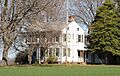
Ashton Historic District
-
Augustine Beach Hotel
-

Duncan Beard Site
-
Belleview
-
Biddle House
-
Gov. Benjamin T. Biggs Farm
-
Brook Ramble
-

Choptank
-
Choptank-Upon-The-Hill
-
Clearfield Farm
-
Cleaver House
-
Cochran Grange
-
Corbit-Sharp House
-
Cornucopia
-
Delaware Boundary Markers
-
Dilworth House
-
Fairview (Odessa, 1850)
-
Fairview (Odessa, 1733)
-
Fairview (Middletown)
-
Fleming House
-
J. M. Gordon House
-
Green Meadow
-
Greenlawn
-

B. F. Hanson House
-
Hart House
-
Hedgelawn
-

Hell Island Site
-
S. Higgins Farm
-
Hill Island Farm
-
S. Holton Farm
-
Huguenot House
-
Idalia Manor
-
Liston Range Front Lighthouse
-
Liston Range Rear Light Station
-
Comdr. Thomas MacDonough House
-
Maples
-
Mayfield
-
Middletown Academy
-
Middletown Historic District
-
Misty Vale
-
Mondamon Farm
-
Monterey
-
Arnold S. Naudain House
-
John B. Nelson House
-
Noxontown
-
Odessa Historic District
-
Okolona
-
Old Brick Store
-
Old Drawyers Church
-
Old St. Anne's Church
-
Old St. Paul's Methodist Episcopal Church
-
Old Union Methodist Church
-
Pharo House
-
Port Penn Historic District
-
Philip Reading Tannery
-
Reedy Island Range Rear Light
-
Retirement Farm
-
Riverdale
-
Rosedale
-
St. Joseph's Church
-
J. Shallcross House
-
Sereck Shallcross House
-
David W. Thomas House
-

Townsend Historic District
-
Vandyke-Heath House
-
Weston
-
Williams House
-
Windsor
-
Woodside


,_0.6_mile_north_of_Middletown,_Middletown_vicinity_(New_Castle_County,_Delaware).jpg)


.jpg)


.jpg)


,_Odessa_(New_Castle_County,_Delaware).jpg)

.jpg)
.jpg)


.jpg)


